Gaia GPS
  • Free Trial
  • Out and Back Podcast
    • Gaia GPS

      “Ninjasticking” Through the Backcountry with Vasu Sojitra

      April 8, 2021

      Gaia GPS

      Out and Back: How to Train for Hiking…

      March 18, 2021

      Gaia GPS

      Mountain Climber Adrian Ballinger Finds Love and his…

      March 4, 2021

      Gaia GPS

      Climber and Entrepreneur Matt Segal on Finding Balance

      February 17, 2021

      Gaia GPS

      Camping and Overlanding Save Atlanta Couple’s Marriage

      February 11, 2021

      Adventures

      Backcountry Skiing in the Himalayas with Mountain Guide…

      February 3, 2021

      Backcountry Skiing

      The Best Backcountry Skiing Gear Recommendations

      January 19, 2021

  • Adventures
    • User Stories
  • Activities
    • Backcountry Skiing
    • Boating
    • Emergency Response
    • Fishing
    • Offroading
  • New Features
  • New Maps
  • Shop Swag
  • Home

Public Land Ownership data available in Gaia GPS

by Andrew Johnson October 15, 2013

Check out an updated public lands layer here.

One of the most common requests we get from Gaia GPS users is for Public Land Ownership data, which is useful for hunting, fishing, exploring, and even business purposes. Today, we’re making a land ownership layer available in Gaia GPS.

You can add the public land layer within Gaia GPS by going to “Add More Layers…” This overlay won’t work very well unless you have Gaia GPS Premium, because it needs to be layered with other base maps. You might have some basic use for it as a regular Gaia user.

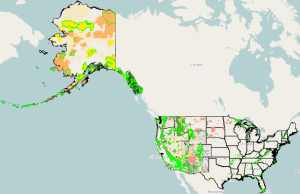
We consider this to be a “beta” effort, and we’re releasing it to you because it’s useful to us, though incomplete. It has excellent coverage of California, fairly detailed coverage of the rest of western United States, including Alaska, and federal lands in the east. Here’s a summary view of the coverage, and you can also view the layer on gaiagps.com:

Screenshot 2013-10-15 15.31.06

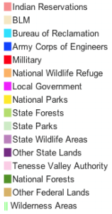
The colors are defined by the following legend, and there is also an entry in the user manual with this info. We’ll integrate it better in the future:

legend

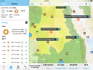
Here’s a screenshot using the layer with GaiaPro, on the iPad. I’m showing the weather panel just for fun, too:

public lands map gaia gps

Gaia GPS premium layers capability really shines here, and you can composite a vast amount of information, including USGS topos, MapBox aerials, Forest Service (USFS) maps, weather overlays, and your personal waypoints and tracks.

Today, our public land data collection efforts are stymied a bit by the shutdown of the US government, but we have plans to complete the data set, and integrate it more fully into Gaia GPS, with an interactive legend and alerts.

This project started out from one of our team’s personal interest in hunting (Jesse), and it’s an ongoing effort. Jesse last lived in Montana, before coming to Berkeley to work with us, and he depended on Elk he hunted for food. As with the rest of Gaia, this comes from the needs of people who spend a lot of time in the woods.

Finally for the technically-minded people. you can also view this GitHub gist for how to set up a tile server like this yourself.
 

Androidios
0
FacebookTwitterRedditEmail
Andrew Johnson

Andrew founded Gaia GPS. He writes code and manages the business.

previous post
The Government Shutdown Strikes Again
next post
New hunting layer in Gaia GPS for Montana

You may also like

Find Trails for Hiking, Biking, and Offroading with...

March 30, 2021

Discover Millions of Routes with the New Public...

March 24, 2021

Get Worldwide 3D Maps on the Web at...

March 22, 2021

Find the Deepest, Lightest Powder with the New...

February 1, 2021

See a Snapshot of the Past With Historical...

January 27, 2021

Identify Avalanche Terrain with the New High-Res, Worldwide...

January 5, 2021

Quickly Find Campgrounds and Trails with the USFS...

November 30, 2020

View Recent Conditions with Two New Satellite Imagery...

November 24, 2020

Find Phone Signal With Cell Phone Coverage Maps

November 19, 2020

Deepen Your Land Knowledge with the New Native...

October 8, 2020

Keep in touch

Facebook Twitter Instagram Youtube

Popular Posts

  • 1

    How to Read Topographic Maps

    October 7, 2020
  • 2

    How to Save Phone Battery Life in the Backcountry

    March 25, 2021
  • 3

    Forrest Fenn’s Treasure has been Found

    March 12, 2019
  • 4

    Gaia GPS and Apple CarPlay Bring Outdoor Maps to Your Dashboard

    February 24, 2020
  • 5

    Easy to Read, Tiny to Download: The All New Gaia Topo

    January 28, 2020

Categories

  • Adventures
  • Android
  • App Comparisons
  • App Updates
  • Backcountry Skiing
  • Boating
  • Company News
  • Emergency Response
  • Featured
  • Fishing
  • Gaia GPS
  • GaiaCloud
  • Hikes
  • How-To
  • Hunting
  • iOS
  • New Features
  • New Maps
  • Newsletter
  • Offroading
  • Out and Back Podcast
  • User Profiles
  • Facebook
  • Twitter
  • Instagram
  • Youtube
  • RSS

@2020 - All Right Reserved. Gaia GPS


Back To Top