Whether you’re backpacking past the white granite pinnacles along JMT, offroading along the turquoise coasts of Baja, or planning a family trip to a national park, adventure with the most trusted and popular recreation maps on the planet.
Meet our collection of National Geographic Trails Illustrated maps, from the eponymous map makers of world-renown. From Yosemite to Zion, the Appalachian Trail to the Pacific Crest Trail, access this coveted collection of NatGeo maps right in Gaia GPS. Priced at $15 plus a pop, get almost all of them with a Gaia GPS Premium membership.
Read on to learn about all the different NatGeo maps in Gaia GPS, why they are so special, and how their detailed notes can take your adventures to the next level.
Adventure Confidently with Maps You Can Trust

Expertly researched and crafted in conjunction with local land managers, NatGeo maps undergo rigorous review and continually set the standard for accuracy. The result: the most trusted and popular recreation maps available.
National Geographic offers over 250 titles for America’s favorite outdoor destinations, most of which you can find right in Gaia GPS. From the long trails to your favorite national parks, NatGeo maps cover the most breathtaking and iconic scenery of the country. They’re packed with useful information, yet remain crystal clear to help you navigate down, off, and back to the trail.
Get Detailed Topographic Information

While NatGeo Trails Illustrated maps cover a vast array of terrain, from the weathered Appalachians to the cavernous Grand Canyon, they all uphold a rigorous level of topographic detail. Easily spy steep slopes and gentle plains with clearly marked topo lines—enhanced with hill shading and precise contour detailing.
Get the elevation for mountain passes, summits, and major lakes right on the map. Tree shading makes finding the alpine a breeze, and rivers pop out from the map in baby blue. Wilderness boundaries are clearly defined by color, labels, and lines, making it easier to follow wilderness policies.
See Info At Every Zoom Level

Unlike our propriety Gaia Topo map, Nat Geo maps are raster files. This means that you see the same information as you zoom in and out from the map. Rasterized maps are less efficient than vectorized ones such as Gaia Topo, but they prove useful when you’re trying to pick out key landmarks from a big-picture view. Use NatGeo maps in conjunction with our trademark base maps such as Gaia Topo, Gaia Winter, and Gaia Overland to get the best of both worlds.
Stay on Track with Clearly Marked Trails

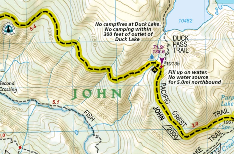
NatGeo maps emphasize major trails, making it easier than ever to find places to explore and to navigate in the field. For trail-specific maps like the Appalachian Trail, Pacific Crest Trail, John Muir Trail, and Colorado Trail, the trail in question is highlighted in yellow and marked with the trail’s symbol.
Know how far until you reach that mountain pass, the next stream, or your campsite thanks to mile markers and distances to the next intersection, bridge, peak, or town.
Find Key Points of Interest

Discover essential resupply stations, water sources, and points of interest you’ll be hard-pressed to find on any other map. Spy trailheads to start your adventure, plus bathrooms and spigots to hit the trail adequately prepared.
Find campsites, resupply stops, and restaurants along the trail for your next backpacking trip. And get off the beaten path by exploring historic sites, memorials, and viewpoints marked on the map.
Go Deeper with Navigational Aids

Perhaps the best part of NatGeo maps are the guidebook notes sprinkled across the map. Get a heads up on which bridges are slippery when wet. See where you’ll have to pack water before long dry spells.
Make sure you camp on legal ground: see where camping is not allowed, and where wilderness areas begin. Get helpful notes like when to pay keen attention to trail markers, and where free shuttles make stops.
Pick the Perfect Map for Your Adventure

With over 240 maps, NatGeo covers many national parks, iconic trails, and breathtaking destinations across the US. Many of these maps are housed in our National Geographic Trails Illustrated map. We also have dedicated map layers for certain Nat Geo Trails Illustrated maps. Check them all out in the map catalog.
Whether you’re planning a weekend backpacking trip in California’s Desolation Wilderness or a family excursion to Big Bend National Park, just open the NatGeo Trails Illustrated map to find iconic views, historic landmarks, and campsites to explore. Navigate Montana’s Bob Marshall Wilderness and Washington’s Wonderland Trail with ease. Discover pristine alpine lakes in Wyoming’s Cloud Peak Wilderness, and find tucked-away nature trails in California’s Joshua Tree. When it comes to the NatGeo Trails Illustrated map, the U.S. is your oyster.
Thru-Hike America’s Long Trails

Heading out on the Appalachian Trail, Pacific Crest Trail, John Muir Trail, or Colorado Trail? We’ve got a Nat Geo map for each of them. You can also find other long trails, like the entire Long Trail and parts of the AZT, in the catch-all Nat Geo Trails Illustrated general map.
In 2017, NatGeo teamed up with thru-hiker and mapmaker Lon “Halfmile” Cooper to produce maps that included both NatGeo’s meticulous cartography and Halfmile’s firsthand notes and insider information. The result contains careful annotations about trail mileages, official and unofficial campsites, water sources, and other points of interest.
You can use any NatGeo map on it’s own. Or pair a NatGeo map with Gaia Topo on your next backpacking trip to get the best of both worlds when it comes to discovering POIs, off-shoots, and camping, while also getting Nat Geo’s insider notes and easy-to-follow trails.
Explore National Parks Like a Pro

From Acadia to Zion, Nat Geo Trails Illustrated covers your favorite national parks around the country. See where the bus can take you through the park, find campsites, and even see which trails are open to horses.
Get inspired for your next family hike with trails featured on the map, and read the notes to see if it seems suitable for those in your group.
Visitor’s centers, bathrooms, wheel-chair accessible trails, and trash cans are all labeled clearly on the map, making it that much easier to spend more time soaking in the views and less time figuring out logistics.
Climb to New Heights

If you’re traveling to Colorado, you’re in luck. In addition to the NatGeo Colorado Trail map, you can tap into the NatGeo Colorado 14ers map which includes coverage of all 58 Colorado peaks above 14,000 feet.
Whether climbed all 58 peaks or are setting out on your first one, check out this map to eliminate the guesswork. See how long your adventure will be, plus total elevation gain and loss. Get directions to trailhead, and see whether you’ll need four-wheel drive to reach it.
Anticipate more engaging sections of the trail like where you can expect to scramble or encounter snow thanks to the notes right on the map. Hoping to camp half way up the hill? See where that’s allowed as well.
Find New Fishing Holes

After climbing a 14er, pull your fishing rod and the NatGeo Fishing & River Maps layer, which covers sections of the Colorado River, Arkansas River, South Platte River, Blue River, Roaring Fork, and Fryingpan Rivers in Colorado.
Built with National Geographic’s characteristic attention to detail, accuracy, and smart map design, this layer is a complete picture of not only the river courses themselves, but their banks, recreation areas, access points, and adjacent ponds and lakes. The result is a complete picture of each river ecosystem, and the boating routes within it.
The NatGeo Colorado Fishing & Rivers map includes clearly marked river miles, access points, put-ins, and the names and ratings of rapids, making it easy to locate yourself on the river, share route information, and plan trips. You’ll also find labeled stream gage sites to reference when researching flow rates at potential fishing or boating spots. Land ownership boundaries and recreation sites also make it easy to scout out campsites along the way.
How to Get the NatGeo Trails Illustrated Maps
All of the NatGeo Trails Illustrated maps are available on gaiagps.com and in the app with a Premium membership. To add any of them to your account, go to “Add map layers.” From here, you can search for a map, or find them under United States map layers or Topo maps.
Use any NatGeo map by itself, or pair it with one of our propriety base maps like Gaia Topo, Gaia Winter, or Gaia Overland for an even richer view of the landscape.
With Premium, you can also download these maps for offline use so you can find your way without cell service. Plus tap into our suite of weather features, safety tools, and hundreds of maps for every activity.