Top Posts
Introducing Adventure Modes: The Right Map for Every...
Trip Report: A Rider’s Guide to Bikepacking in...
How to Hike a Colorado 14er: A Step-by-Step...
Trip Report: A Rider’s Guide to link Boulder...
Trip Report: A Rider’s Guide to the South...
Battling the Wind: Setting Your Shocks to Firm...
The Hike Map That Broke Me: How Gaia...
A Fond Farewell to National Geographic Maps —...
Introducing the Gaia Hike Map: Plan Your Hike,...
Download the app and get a free 14-day...
Gaia GPS
  • Explore The Map
  • Get the App
  • Upgrade Today
  • Explore The Map Catalog
  • New Features
  • Activities
    • Backcountry Skiing
    • Boating
    • Emergency Response
    • Fishing
    • Offroading
  • Adventures
    • User Stories
  • Help

New Features

Gaia GPSNew Features

Introducing Adventure Modes: The Right Map for Every Adventure in One Tap

by Eric Evans August 13, 2026
written by Eric Evans

There’s a certain kind of person who shows up at the trailhead with three different plans. Maybe it’s a hike if the snow looks manageable. Maybe it’s a ski tour if it doesn’t. Maybe it turns into a full-on off-road detour because someone spotted a Forest Service road that looked too good to ignore. You know who you are. We built this for you.

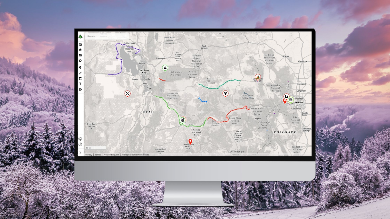
Today, we’re launching Adventure Modes, and it’s the biggest change to how Gaia GPS works since, well, Gaia GPS. Adventure Modes sets up your map with all the right data and layers for however you hit the trail.

One App. Every Adventure. Zero Reconfiguring.

Here’s the thing about the outdoors: it doesn’t care about your app’s information architecture. A weekend can start as a snowshoe, pivot to a ski descent, and end with you airing down the tires for a dirt road you definitely didn’t plan on. Until now, your map couldn’t keep up.

Adventure Modes changes that. Every mode is built around what your activity actually demands. It’s one map, purpose-built for however you’re getting out there.

When you launch Gaia GPS on the web or app, you’ll find three new modes waiting for you:

  • Hike – Trail overlays, terrain shading, waypoints, and the layers that matter when you’re moving on foot. Whether it’s a casual walk or a 14-day traverse, your map is dialed for the trail.
  • Off-Road – Surface type, road classifications, 4×4 tracks, and satellite imagery front and center. The map your rig deserves, ready before you hit the dirt.
  • Snow – Slope angle shading, avalanche zones, snowpack layers, and Nordic routes. Because going into the mountains in winter with a summer hiking map is how epics turn into incidents.

Switch between them with a single tap. No settings menus. No digging through layer toggles. No, “Wait, why is this map showing me bike trails when I’m on snowshoes?” Just the right map for the right adventure, right now.

Adventure Modes makes dialing in your map quicker and simpler than ever before. Pick your activity, adjust what you need, and Gaia GPS remembers your setup the next time you head out.

Your Map, Your Way – Without the Setup Tax

We’ve all been there. You open a mapping app, and before you can even look at the terrain, you’re configuring layers, toggling sources, and wondering why the app thinks you want cycling infrastructure when you’re planning a ski tour.

Adventure Modes eliminates that entirely. Every mode comes pre-loaded with the basemaps and overlays you need to adventure with confidence. Hike mode doesn’t clutter your screen with off-road tracks. Snow mode isn’t hiding your slope angle data three menus deep. Off-Road mode has the satellite imagery you need without you having to go looking for it.

And if you want to customize further? Custom Mode brings you back to the original Gaia GPS experience. It works the same as always – full flexibility, no restrictions. Build your map setup however you want with our deep layer library of USGS quads, aerial imagery, slope shading, and dozens more. Use it like another mode whenever you want complete control.

For the People Who Don’t Just Do One Thing

Most outdoor apps are built for one type of adventurer. Hike this trail. Follow this route. Stay in your lane — literally.

Gaia GPS has always attracted a different crowd. The people who hike out and ski back. Who overland to the trailhead and then hike to the summit. The crowd who knows that the best adventures usually start with a plan and end somewhere completely different.

Adventure Modes is built for exactly that kind of person. You’re not a hiker or an off-roader or a backcountry skier. You’re all of those things depending on the day, the season, and what the road looks like. Now your map works the same way.

Available Now on Web and Mobile

Adventure Modes is live today on Gaia GPS on the web and mobile. No waitlist, no setup, just open your map, pick your mode, and go.

If you’re new here – welcome. There’s a lot of world out there, and we’ve been mapping it obsessively for a long time. Adventure Modes is the best place to start.

If you’re a longtime Gaia user, you’re going to feel this immediately. The app you already trusted just learned how to read the room.

Try Adventure Modes on the web, Android, or iOS app now.

Hike far. Drive deep. Ski everything. We’ll handle the map.

August 13, 2026
0 FacebookTwitterLinkedinRedditEmail
Gaia GPSNew Features

The Hike Map That Broke Me: How Gaia GPS Turned an Overlander Into a Reluctant Hiker

by Eric Evans April 24, 2025
written by Eric Evans

Hi. I’m an Overlander.

I believe in four-wheel-drive, traction boards I’ve never used, a rooftop tent that folds into a box of mystery, and a 65-liter fridge dedicated entirely to La Croix and “emergency cheese.” I’ve driven 200 miles to camp 20 feet from my truck and called it “getting outside.”

So when the team launched the new Gaia GPS Hike Map, I had exactly one reaction:

Cute.

A map for people who walk on purpose? Who carry their sadness uphill in tiny backpacks full of granola dust and emotional processing? Hard pass.

Then I opened it.

And… damn it, it’s good.

The trail lines are crisp. The junctions actually make sense. And the shaded relief? So emotionally intense, I needed to hydrate and reevaluate my personality.

But what really got me was the detail.

This map doesn’t just show trails — it knows hikers.

It’s built for the folks who lose toenails on purpose and log their mileage like it’s a journal entry. The Hike Map includes major thru-hikes across North America and Switzerland — like the Pacific Crest Trail, the Appalachian Trail, the Colorado Trail, and more. If it’s long, scenic, and a little bit emotionally scarring, it’s probably on here.

And the steepness overlay? Yeah. That’s not just color — that’s warning.

You can see where the trail goes vertical before you’re halfway up it questioning every decision you’ve ever made. No more “how bad can it be?” lies. This map tells the truth.

It also highlights key points of interest just for hikers:

  • Trail campsites
  • Water refill spots
  • Rivers and streams marked clearly with hydrography data that actually means something

    Basically, if it’s something you’ll need when you’re six miles from nowhere and starting to consider drinking out of a mud puddle, it’s probably on this map.

Back to my story: ten minutes after opening the map, I found myself standing at a trailhead — 12-mile loop planned, peanut butter bar in hand — six feet from the edge of the parking lot… and thinkin’:

“This is how it happens, isn’t it?”

Then some 70-something named Linda blew past me in zip-off pants and a sun hat made of pure contempt. She didn’t say a word. She just looked at me like my Jeep had disappointed her personally.

By mile six, I’d activated Trail Regret Mode™: lips cracked, thighs fried, chafing in places I won’t legally discuss. I would’ve traded my fridge, my solar array, and at least one swing-out bumper for a banana and a flat place to cry.

But here’s the thing… this map is built for people like Linda. The hikers. The planners. The “I found myself somewhere near mile 70” types who actually read elevation profiles for fun.

And now they’ve got the most powerful hiking map we’ve ever made — with global trail coverage, terrain data, steepness visualization, and trail-specific POIs, all designed to get you where you’re going and keep you on your feet along the way.

So yeah. Big shoutout to the team.

You didn’t just build a map —

You ruined my Overland personality and turned me into someone who knows how many liters their pack holds.

I own a spork now. I said “stoked” the other day. I’m probably not okay.

But the map?

The map slaps.


Try the Hike Map Yourself

Ready to see what it’s like to become a hiking person against your will?

Just open the Hike Map in Gaia GPS and start exploring.

Or, if you’re already halfway to emotional collapse on the PCT, we’ve probably already mapped your next breakdown.

April 24, 2025
0 FacebookTwitterLinkedinRedditEmail
Gaia GPSNew FeaturesNew Maps

Introducing the Gaia Hike Map: Plan Your Hike, Your Way

by Eric Evans March 18, 2025
written by Eric Evans

At Gaia GPS, we eat, sleep, and breathe trails—well, maybe not literally, but pretty close. That’s why we’re rolling out the new Gaia Hike Map, designed to take the guesswork out of your next adventure. No more fumbling with multiple layers—just turn it on and go. The Gaia Hike Map is live now with a Premium membership. Simply go to Map Layers and enable it.

A Global Map Built for Hikers

Whether you’re thru-hiking the Appalachian Trail, exploring the Alps, or just escaping town for the weekend, this global map has your back. No need to stack layers like an overstuffed backpack—everything you need is already here.

Steepness Overlay: No More Underestimating That Climb

The biggest game-changer? Our new steepness overlay. For the first time in Gaia GPS, we’re color-coding trails to show you just how quad-melting that next section might be. We took special care to analyze hiking and biking activity data in choosing which trails to highlight to provide a best-in-class trail network for hiking.  Green means easy, yellow means mellow, orange gets spicy, red is tough, and purple? That’s straight-up brutal.

Love a challenge? Chase those reds and purples. Prefer to keep it casual? Stick to the greens and yellows.

We’re still fine-tuning this feature, and your feedback will help us find the right balance. Let us know how it works on your favorite trails!

More Than Just Trails

The Gaia Hike Map doesn’t stop at paths—it’s packed with key waypoints to keep you moving and well-fed:

  • Water Fill-Ups – Hydrate or die-drate, as they say.
  • Campsites, Lodging & Food Stops – Whether you’re pitching a tent or hunting for a post-hike pizza.
  • Land & Trail Access Info – Know where you can hike and camp without worry.
  • Hydrographic Data – Lakes, rivers, and streams so you can plan your next foot soak.

The Gaia Hike Map is available in feet and meters:

  1. Open Gaia GPS.
  2. Go to Map Layers.
  3. Search for Gaia Hike Map and turn it on.

We’ve got more trails ahead, and your feedback helps us keep improving. Tag #GaiaGPS in your adventures and let us know what you think!

See you on the trail (or at the burger joint after).

March 18, 2025
8 FacebookTwitterLinkedinRedditEmail
Gaia GPSNew Features

Unlock a New Level of Personalization in Gaia GPS with Photo Waypoints

by Jules Semotuk December 12, 2024
written by Jules Semotuk

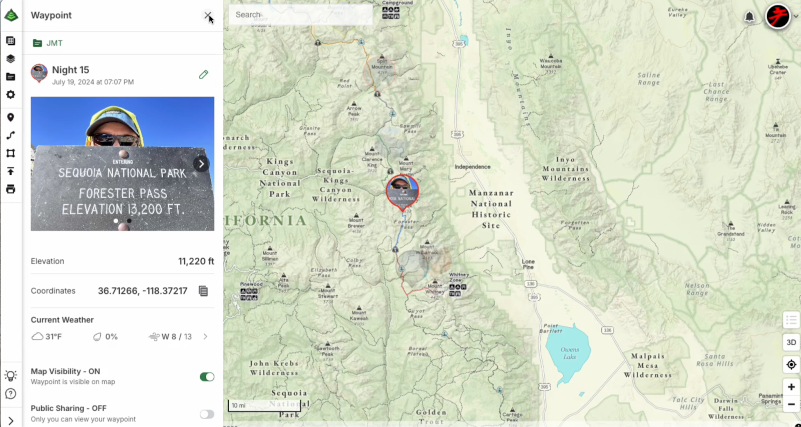
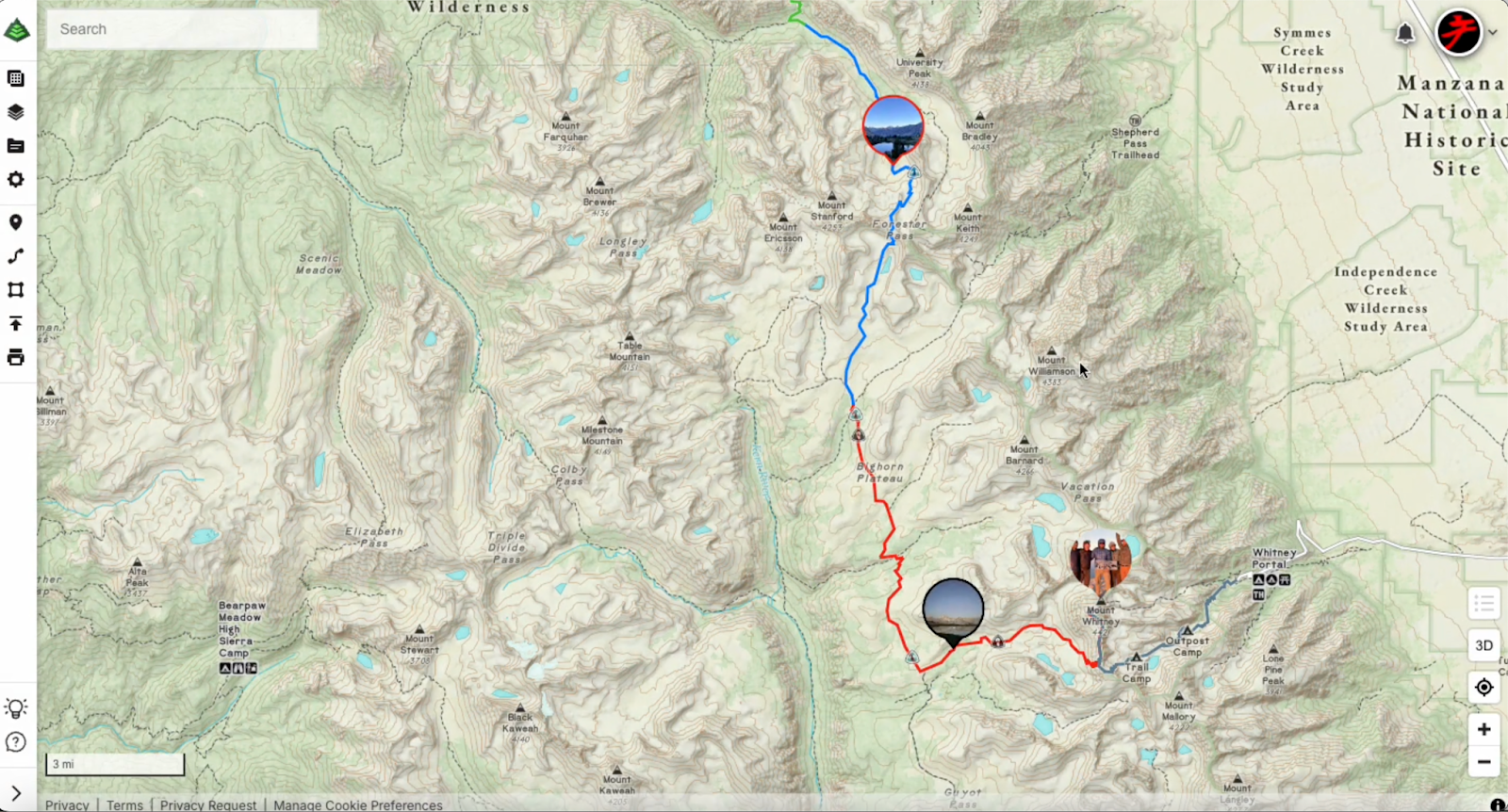
Get ready to elevate your Gaia GPS adventures with the brand-new photo waypoint feature! While emoji icons are fun for marking locations, this exciting update lets you add images to your waypoint icons, taking your map personalization to the next level. With Photo Waypoints, you can make your maps more personal and visually rich, helping you navigate with greater ease and relive your experiences in a whole new way. Whether you’re out exploring, planning your next pursuits, or perhaps revisiting previous journeys, this upgrade transforms your maps into a truly personal and visually stunning experience. 

Photo Waypoints Are Available on the Web with Gaia GPS Premium

Photo Waypoints are a premium feature exclusively available on the Web with a Gaia GPS Premium or an Outside+ membership. With a subscription, you’ll unlock Photo Waypoints along with an array of other premium features to enhance your outdoor experience, including our 300-plus map catalog, offline navigation, and more.

How It Works

Creating Photo Waypoints on the web as a Gaia GPS Premium user is easy and just takes a few steps. Here’s how: 

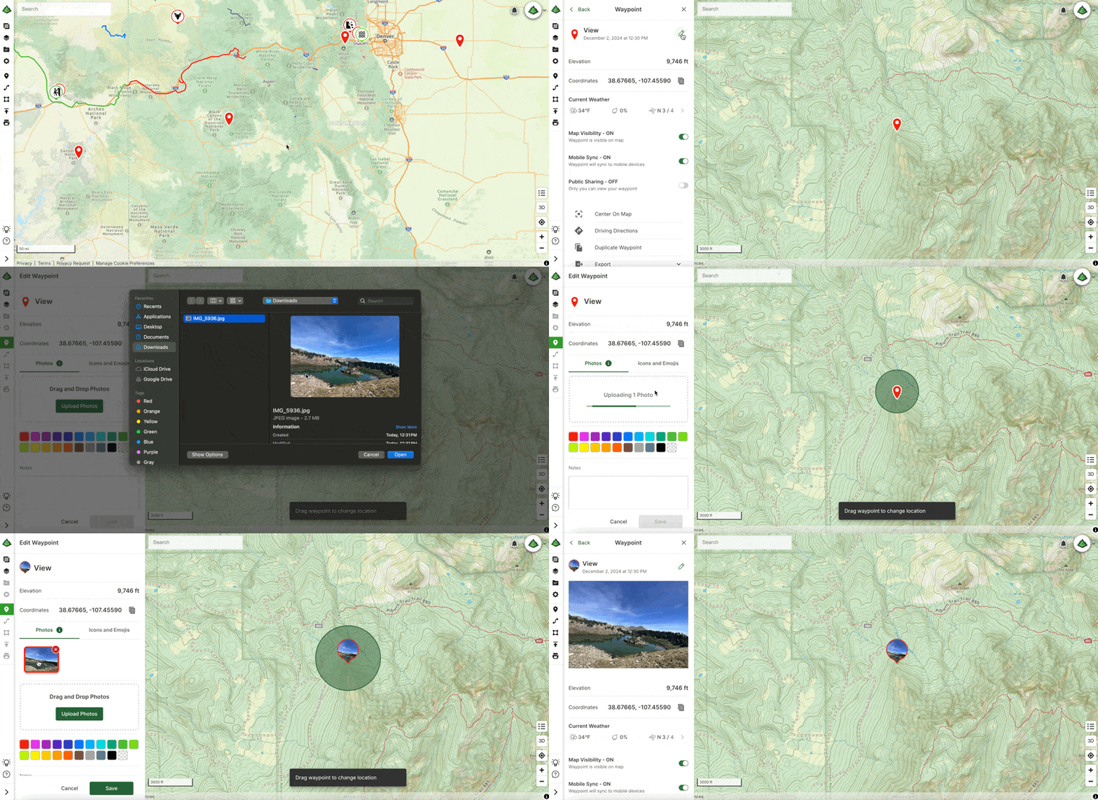
  1. Visit gaiagps.com on your desktop. Log in or create an account. 
  2. Select a waypoint you would like to edit from the Saved Items sidebar.
  3. Click the pencil icon to the right of the waypoint title to edit the waypoint.
  4. If not already selected, click the Photos tab and then click ‘Upload Photos.’ 
  5. Once your photo(s) are uploaded, choose a photo to use as the waypoint icon photo, then click save!

That’s it! Now your waypoint has a personalized touch, adding a new layer of meaning to your adventure.

Personalize Your Adventure with Gaia GPS

Gaia GPS empowers you to create personalized, detailed, and memorable maps that enhance your preparation and documentation of your outdoor experiences. With the new Photo Waypoint feature, you can use images to capture and recall key locations along your journey. Whether you are an outdoor enthusiast documenting new hikes and viewpoints, a traveler looking to mark destinations and favorite spots on the road, or a photographer creating a photo journal of your outdoor excursions, the Photo Waypoint feature is here to help you transform your maps into visual representations of your unique experiences. 

Begin Customizing Your Maps Today

Ready to make your next adventure even more memorable? Dive into our easy Help Center guide on creating and editing waypoints, and start customizing your maps today! Learn more here: Edit Waypoints on gaiagps.com

December 12, 2024
0 FacebookTwitterLinkedinRedditEmail
Gaia GPSNew Features

Goodbye Clutter, Hello Streamlined Maps: Introducing Sync to Mobile

by Jules Semotuk November 26, 2024
written by Jules Semotuk

Have you ever found yourself scrolling through your Gaia GPS app, searching for that one piece of data you need, only to get lost in a sea of old adventures you’ve already completed? It’s time to put that behind you! Say goodbye to clutter in the app, and hello to a more streamlined mapping experience. 

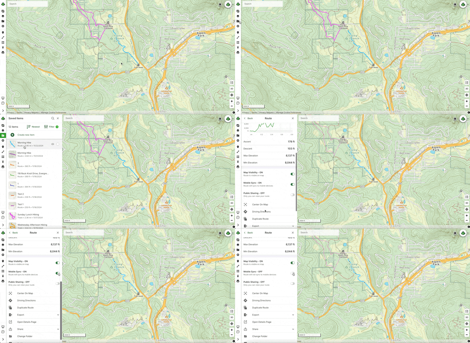
Meet Sync to Mobile – a new feature that lets you tailor your sync preferences to decide what data you want on your mobile device, all while keeping all your data viewable on gaiagps.com. This new feature makes managing your data in Gaia GPS easier than ever and ultimately completes the lifecycle of your adventures.

Sync Only What You Need 

As the new year approaches, it’s a great time to declutter, both physically and digitally. If you’ve been using Gaia GPS for a while, you’ve probably noticed an accumulation of old data on your device. Maybe it’s a swarm of waypoints from a long-forgotten trip or a track you recorded years ago. It’s great to have memories of your adventures, but let’s be honest—do you need every old route and track synced to your mobile device when you’re heading out on a new adventure? 

Gone are the days of having to sync all of your data to the app. Now, Sync to Mobile allows you to focus on what you currently need in the app, while still preserving your memories and data on the web. Think of the web platform as hanging a paper map on your wall to plan and remember your life’s adventures, and let the app be focused on data for your current endeavor. Here’s how to use the new Sync to Mobile feature: Organize Your Data with the Sync to Mobile Feature on Gaiagps.com.

From Planning to Reflection

Gaia GPS has always been a powerful tool for both planning and navigating your outdoor excursions. The new Sync to Mobile feature takes it a step further by allowing you to manage your data across devices with greater control. Imagine Gaia GPS as the ultimate command center for your adventures—the web interface is your mission control, where you can plan and organize your trips, while your mobile device is your trusty companion in the field.

Sync to Mobile enables you to select exactly which data (tracks, routes, waypoints, etc.) you need on the app for a particular trip—whether you’re heading out on a multi-day overlanding adventure or just going for a day hike. By utilizing this feature, you not only reduce the clutter on your mobile device, but less data on the app also decreases loading times, ultimately upgrading the Gaia GPS app’s performance and efficiency. 

Once you’ve finished your trip, turn Sync to Mobile off on the data you no longer wish to sync to your device. You’ll still be able to see your saved data on the web—so don’t worry, your past trips will be there for reminiscing. However, by turning off Mobile Sync for completed trips, you can decrease loading times and improve the performance of the Gaia GPS app. A win-win, if you ask me!

A Smarter Way to Archive

With Sync to Mobile, the archiving feature takes on a new role. In the past, archiving was your way of managing what data you didn’t want synced to your device, but this had the side effect of removing that data from the web map as well. Now, you can selectively choose which data you want synced to mobile without the hassle of archiving. This is a game-changer for anyone who likes to keep a record of their adventures without being weighed down by unnecessary data while you’re on the go. Moving forward, you can think of archiving as a soft delete, rather than a sync management tool. Items can still be restored from an archived state (or deleted permanently), similar to how the trash can works on a computer’s operating system.   

How to Get Sync to Mobile

Anyone with a Gaia GPS account can take advantage of this new feature on the web at gaiagps.com. If you also want access to premium maps and features, you can upgrade to a Gaia GPS Premium or an Outside+ membership. 

Gaia GPS Premium or Gaia GPS with Outside+ gives you access to the entire 300+ map catalog. With Premium, you can also download maps for offline use so you can find your way—even without cell service. You can layer maps together to reveal even more terrain, weather, and safety features. And you can print custom maps.

With Outside+, you’ll also receive unlimited access to digital content from Outside and 15 other brands—think recipes, meal plans, and training tips from Backpacker, RUN, and more. Explore new routes with Trailforks Pro, and stream 600+ hours of ski and climbing action, survival challenges, travel documentaries, and more with Outside TV.

So, what are you waiting for? Try Sync to Mobile today for your next adventure with Gaia GPS!

November 26, 2024
0 FacebookTwitterLinkedinRedditEmail
Gaia GPSNew FeaturesNew Maps

Discover Prime Stargazing Locations with Our New Light Pollution Map

by Tricia Speziale Edwards August 15, 2024
written by Tricia Speziale Edwards 3 min. read

Calling all stargazers and photographers! We’re excited to introduce our new and improved Light Pollution map layer. Using an easy-to-read color scale, this upgraded map is designed to help you find the best locations for observing the night sky. Whether you’re an avid astro-nerd looking to push your telescope to its limits or simply someone who enjoys the tranquility of a star-filled night, this map is your gateway to darker skies and more brilliant celestial views. 

How to Access the Light Pollution Map

  1. Visit gaiagps.com on your desktop or open the iOS/Android app on your mobile device.
  2. Locate the layers icon (left sidebar on desktop, bottom left corner on mobile).
  3. Select “+ Add Map Layers” and search for “Light Pollution.”
  4. Tap the ‘+’ icon to add the layer to your map.

Pro Tip: For optimal viewing, overlay the Light Pollution layer on our Gaia GPS Black and White map. This combination allows you to see the color scale of light pollution and essential map details.

Optimizing Your Stargazing Experience

The upcoming Perseid Meteor Shower presents a perfect opportunity to test our new map. While light pollution significantly affects the visibility of diffuse objects like comets and galaxies, you can still enjoy meteor showers even in moderately light-polluted areas (shown in red on our map).

For the best meteor-watching experience:

  1. Aim for areas colored Green through Black on our Light Pollution scale.
  2. Allow your eyes to adapt to the darkness for at least 20-30 minutes.
  3. Consider additional factors such as moon phase, weather conditions, and cloud cover.

Remember, darker skies will reveal more meteors and enhance the overall spectacle of the shower.

Unlock the Full Potential with Gaia GPS Premium

The Light Pollution map layer is a premium feature available to Gaia GPS Premium and Outside+ members. Your subscription grants you access to our 300-plus map catalog, offline navigation, plus planning, recording, and sharing tools. Adventure safely with Gaia GPS Premium’s suite of weather features and safety tools including air quality, wildfire maps, and slope angle shading.

Elevate your stargazing adventures and outdoor experiences with Gaia GPS Premium. Start exploring darker skies and brighter stars today!

August 15, 2024
0 FacebookTwitterLinkedinRedditEmail
two people look at a phone while pointing to mountains in the distance.
Gaia GPSNew Features

2023 Mapped: Our Best New Features of the Year

by Abby Levene December 27, 2023
written by Abby Levene

As the world opened back up in 2023, the Gaia GPS community adventured further, deeper, and higher than ever. As you climbed new peaks, skied new trails, and camped in new spots, our team back at home worked tirelessly to make Gaia GPS even better for your adventures. 

From shiny new features to the invisible work behind the scenes that keeps Gaia GPS running smoothly and reliably while you’re out in the backcountry, here are the top new features and maps from 2023. Thank you for being part of our community, and cheers to another year outside!

Get the Best Off-Pavement Routes with BDR Integration

Photo: Backcountry Discovery Routes

Sometimes, it’s a relief—even a delight—to follow a trusted off-pavement route you know will go. Especially when you know it will go past breathtaking views, across challenging terrain, and to memorable watering holes. That’s why we partnered with Backcountry Discovery Routes to bring you premier long-distance off-pavement routes with a leading navigation experience.

Thanks to this partnership, you can take any iconic long-distance Backcountry Discovery Route offline in the Gaia GPS app with just one click. We’re also honored to promote BDR’s mission of promoting responsible travel and fostering sustainable adventuring and economic growth.

Spy Points of Interest Easier Than Ever with New Map Spotlight

Our proprietary Gaia Topo, Gaia Overland, and Gaia Winter maps equip backcountry travelers on foot, wheels, and skis with the information they need to adventure safely and confidently From trails color-coded by activity type to lands shaded by ownership, to amenities to points of interest, these maps have a lot of information packed in them. Honestly, it’s a lot to take in. (In the best way.) That’s where the map legend comes in. The map legend cracks the code. And now the map legend is even easier to find, decipher, and use. 

Meet our brand new interactive map spotlight on gaiagps.com. Simply click on a symbol and the map lights up, showing you the trails, amenities, or points of interest you’re looking for. Whether you’re searching for a waterfall, an ice cream shop, or a horseback riding trail, the spotlight puts the world at your fingertips.

Draw Routes in Android

In addition to our gold-standard snap-to-trail route planning, which is available across iOS, Android, and gaiagps.com, this year we unveiled route drawing on the Android version of our app. 

Simply click the finger icon on the bottom of the screen and draw on the map to create your route. This route planning mode is particularly useful when you’re going off-trail, where snap-to-trail route planning isn’t available. iOS users: Don’t worry we’re coming for you too!

See the World More Clearly with Gaia Black and White Map

Move over technicolor, black and white is back in style. Meet Gaia Black and White, our very first all-black-and-white topo map. Whether you’re color vision deficient or want a crystal-clear paper map printout on hand, Gaia Black and White is for you.

Styled in the same manner as our other proprietary topo maps designed in-house, Gaia Black and White brings you industry-leading clarity, accuracy, and file-efficiency. Like our other Gaia Series maps, Gaia Black and White provides world-wide coverage. Download the map to use offline for your entire state so you can always find your way—even without cell service. 

Reap the Rewards of Our Type 2 Engineering™

As our software has increased in complexity, our number of users has grown, and the app is utilized in unexpected ways (we’re looking at you, users who record their flights in the app), the proclivity of systems to fail in remarkable fashion skyrockets. 

Our engineers bushwhacked through the code base in an endeavor they called type 2 engineering. Like type 2 fun, it was hard but rewarding work that we enjoyed…once we were done. Along the way, we squashed bugs, improved our design, and cleaned up shared folders. And the outcome is that moving forward, we’ll be able to bring you new features and improvements faster than ever. 

Adventure Intuitively with Our Redesigned App

We take your feedback seriously over here at Gaia GPS, and that’s why we’ve worked tirelessly to make our iOS and Android apps more intuitive and easier to use. This year, we simplified the top five features in the app so you can spend less time looking at your phone and more time exploring. Waypoints, locating yourself on the map, taking a geotagged photo, recording an activity, and downloading maps for offline use are easier to access than ever.

Think of this update like reorganizing the gear shed. All the tools you know and love are still there. We’ve simply moved them to more convenient locations and gave them a fresh coat of paint. 

December 27, 2023
0 FacebookTwitterLinkedinRedditEmail
Gaia GPSNew Features

Discover Adventure Easier Than Ever with New Map Spotlight

by Abby Levene July 27, 2023
written by Abby Levene

Gaia GPS provides the best backcountry maps in the world. (We’re not biased or anything.) Our proprietary Gaia Topo, Gaia Overland, and Gaia Winter maps equip backcountry travelers on foot, wheels, and skis with the information they need to adventure safely and confidently From trails color-coded by activity type to lands shaded by ownership, to amenities to points of interest, these maps have a lot of information packed in them. Honestly, it’s a lot to take in. (In the best way.) That’s where the map legend comes in.

The map legend cracks the code. And now the map legend is even easier to find, decipher, and use. 

Meet our brand new interactive map spotlight on gaiagps.com. Simply click on a symbol and the map lights up, showing you the trails, amenities, or points of interest you’re looking for. Whether you’re searching for a waterfall, an ice cream shop, or a horseback riding trail, the spotlight puts the world at your fingertips.

Find Trails, Campsites, Amenities, and Much More

Gaia Topo, Gaia Overland, and Gaia Winter each contain over 100 icons, symbols, and trail types so you can find new trails, campgrounds, ski resorts, and beyond. Don’t worry, there’s no need to memorize them all! Whether you’re looking for hiking trails, peaks, or hot springs, backcountry skiing, viewpoints, or gas stations, the map legend spotlight will light them up on the map.

How to Use the Map Legend Spotlight

Just head over to gaiagps.com on your computer. (Trust us, the big screen is the optimal place for route planning.) Open up Gaia Topo, Gaia Overland, or Gaia Winter. And then click the map legend icon in the bottom right corner. The pop-out will automatically show you the symbols most prominently displayed in the region of the map on your screen. Hover over a symbol, and watch the map come to life.

RELATED: CREATE YOUR OWN ADVENTURE ON THE BIG SCREEN WITH GAIA GPS

Zoom in and out and pan around on the map to find other points of interest.

If you just want to look at the good old fashioned map legend, never fear. We have that too. View the entire map legend at once by clicking “View Layer Details” on the bottom of the map legend popout. 

Map Spotlight is Available for Everyone on the Web

Anyone with a Gaia GPS account can take advantage of this shiny new feature on their computers at gaiagps.com. To access our premium maps such as Gaia Overland and Gaia Winter, upgrade to a Gaia GPS Premium or an Outside+ membership. 

Gaia GPS Premium or Outside+ gives you access to the entire 300+ map catalog, including high-resolution, world-wide satellite imagery; our suite of National Geographic maps; and specialty maps ranging from historic topos to slope angle shading.With Premium, you can also download maps for offline use so you can find your way—even without cell service. You can layer maps together to reveal even more terrain, weather, and safety features. And you can print custom maps.

July 27, 2023
0 FacebookTwitterLinkedinRedditEmail
Gaia GPSHow-ToNew Features

Meet Map Packs: A Totally New Way to Map

by Abby Levene April 20, 2023
written by Abby Levene

A totally new way to map is now available for all users! Meet map packs.

With over 300 maps, our deep map catalog is one of our greatest assets. And yet we offer so many maps, it can be hard to even discover them all — much less learn how to use them all. To put the best maps in your hands, right now, we’ve totally redesigned our mapping interface. 

Turn on map packs and get the best map presets curated by the Gaia GPS team. Whether you’re visiting a national park with your family, backpacking a long trail, or skiing in the backcountry, just tap the map pack crafted specifically for your adventure. Or create your own map pack so you can always have your favorite map combinations at your fingertips. 

And don’t worry, you can still use our maps exactly as you always have, if you prefer. 

What are Map Packs?

Map packs instantaneously put the best maps in your hands in one tap. No fuss. No digging into the depths of your memory to remember the exact map combinations you like for each activity.

Traditionally, Gaia GPS works by choosing a base map, which you can use on its own. Or you can layer additional maps and overlays on top of it. The most classic example is selecting Gaia Topo, our proprietary map designed in-house, as your base map. You can use Gaia Topo all on its own. Or you can use Gaia Topo as a base map and put weather overlays, cell coverage maps, wildfire maps, or any other map or overlay on top of it. We call this “map layering.”

Map packs does all of this layering for you, saving you time and brain power. Our team has curated the most useful map combinations and meticulously selected just the right opacity for each layer in the pack.

Whether you’re overlanding, stargazing, or just want to check the weather for the weekend, select the map pack perfectly curated for your needs. For example, rather than individually selecting Gaia Winter with Slope Angle, Avalanche Forecast, SNOTEL, and Snow Depth when you go backcountry skiing. Just choose the Backcountry Skiing map pack and you’re good to go, with each map layered to just the right opacity so that you can access the info you need to ski smartly and safely. 

So, if you choose to use map packs, all you have to do is select the map pack you would like, whether that be for wildfires, weather, cell coverage, you name it. And voila, the map shows you all the info you need. In short, map packs give you the maps you want, hassle free.

How to Activate Map Packs 

If you’re an iOS user, you may remember we rolled out this beta feature last year. We’re pleased to report map packs are now available on Android as well. To try map packs out: tap “Settings” (bottom right corner of the app) → “Map Controls” → toggle on “Map Packs (beta).”

Once you turn on map packs, you’ll notice that changing the map sources displayed on your screen looks different. To change maps:

  • Click the map icon on the bottom left corner of the map.
  • From here, you can peruse our curated collection of map packs by scrolling through the list or searching for a specific map or activity.

You can also build your own map pack:

  • Tap “Build a New Map Pack”
  • Select the layers you want
  • Change the opacity and order in which the maps are layered.
  • Add a memorable title and a description, if you like.
  • Tap “Done.”

Want to check the weather, the snow depth, or the air quality? You can also add overlays in one tap, pre-set to the opacity we’ve deemed most useful.

You’ll notice this same map icon on the bottom left corner is now where you can toggle on and off saved waypoints, tracks, routes, and areas.

A Note About Syncing

As a beta feature, map packs currently do not sync from one device to another. In addition, you will lose your map pack data if you uninstall and reinstall the app, or clear the app data in Settings.

Unlock all Map Packs with Premium

Access the best map packs for every activity like overlanding, hiking, and bikepacking by upgrading to Gaia GPS Premium. Premium also gets you weather forecasts, air quality maps, slope angle shading, and every other feature available in the app.

Please Share Your Feedback!

We’re continuously improving map packs. We know this beta feature isn’t perfect, and we would love your help to make it better. Help us make using our maps as easy as possible by leaving us some feedback. What do you love about map packs? What do you hate? How can map packs (and using maps in general) better help you get outside on your adventures?

Share your feedback with us by contacting our Support team. You can also Tweet at us or post on Reddit… 

April 20, 2023
0 FacebookTwitterLinkedinRedditEmail
rec.gov reservations in Gaia Topo
Gaia GPSNew Features

Book Campsites Right From Gaia GPS

by Abby Levene February 23, 2023
written by Abby Levene

We realize it’s still winter. But put on your sandals and sunscreen because it’s time to snag that primo campsite for summer. Many campgrounds in your favorite national parks, state parks, and national forests take reservations six months in advance. That means the best campsites in the most desirable places around America are going quick for peak summer dates. Now you can make those campsite reservations in a flash right from our Gaia Topo map.

Just open Gaia GPS and poke around the map to find that campsite with the spectacular sunrise view. Or search for a campsite far away from the crowds. Either way, you can discover and reserve the campsite of your dreams right from the map. Simply click on a campground and Gaia GPS provides the link on recreation.gov to snag a reservation.

In addition to reservations, recreation.gov gives you every detail you could possibly want about a campsite. View photos to see if the campsite has the spectacular mountain view. Find out how many cars are allowed, and if pets and campfires are permitted. Even see if there’s a fire ring or a grill.

Recreation.gov Campsites in Gaia Topo

Rec.gov campsites shown on Gaia Topo.

The ultimate tool for reserving public campsites in the US is now accessible right from our app. An official US government resource, Recreation.gov is the go-to reservation hub for 12 federal partners including the National Park Service, the US Forest Service, and the Bureau of Land Management. Rec.gov compiles reservations, venue details, and descriptions for over 130,000 recreation locations and more than 4,200 sites and activities around the country.

Plan a family trip to a national park. Or scheme up a solo bikepacking adventure through National Forest land. No matter your style, this new reservation integration makes your life a little easier. Map out your trip and book your reservations all together in one place.

Find All the Campsite Info You Need

A campsite on rec.gov shown on Gaia GPS.

Whether you’re a planner who loves to book campsites far in advance, or someone who prefers to fly by the seat of their pants, check out campgrounds in Gaia Topo to discover everything you need to know about staying there. See where each campsite is located. Find the outhouses and water spigots. Even see where the campground host resides.

Once you find a campsite that looks enticing, click the link to recreation.gov to view:

  • photos of the campsite (see if there’s a view!)
  • pet regulations
  • campfire rules
  • if RVs are permitted, and if so, maximum length
  • if tents are permitted

You also get site details, including:

  • if there is electricity
  • if the site is accessible by foot
  • check-in and check-out times
  • maximum number of people
  • if overnight camping is permitted
  • capacity rating
  • proximity to water
  • whether there’s shade
  • amenities, including if there’s a picnic table, fire pit, and grill or fire ring

And finally, scroll down for need-to-know details including whether there is water and if there are any site fees.

How to Book Campsites in Gaia GPS

Campsite reservations are found in our cornerstone Gaia Topo map. To reserve campsites from Gaia GPS, start by making sure Gaia Topo is selected as an active map layer. Gaia Topo also happens to be the premier map for dreaming up your adventures. Our cartographers designed this map to make key features for backcountry travel, like trails, scenic overlooks, and campgrounds, pop out from the landscape.

Explore Gaia Topo to find campgrounds at your destination. Look for blue campground symbols that say “Reservation Information” under the name. Zoom in further to spy individual campsites, restrooms, and the camp host site.

Once you’ve found your dream campsite, click on “Reservation Information.” The recreation.gov link to reserve campsites in that campground will pop up so you can snag your favorite site before it’s too late. Keep in mind that many public campgrounds take reservations six months in advance. And the best campsites book up quickly! Of course, please be mindful of recreation.gov’s rules and reservation policies.

Plan, Reserve, and Navigate All in One Place

With world-class maps and route-building tools, Gaia GPS provides the ultimate platform to plan your trips. Whether you’re backpacking in the Rockies, overlanding across the southwest, or simply looking for the ultimate car camping spot, choose from our deep collection of maps tailored to your adventure. Map out your route with our quick and easy snap-to-trail route builder so you know exactly where to go.

As you map out your route, you can seamlessly reserve campsites with one click. Drop a waypoint on the map to remember where the campsite is. Your future self trying to find your campsite at midnight in the pitch black will thank you. Speaking of finding your way, go ahead and download the map after you plan your route. That way you can navigate along the route and to your campsite even if you have no cell service at all.

Fun fact: Gaia Topo is so efficient that you can download the map for your entire state in a matter of minutes without clogging up precious phone storage. Don’t worry, you still get the most precise and detailed backcountry map on the market.

Recreation.Gov Campsite Reservations are Available to Everyone

Campsites in Gaia Topo.

Everyone can access the Gaia Topo map and make campsite reservations within it. You just need to create a free Gaia GPS account. To access our entire collection of maps, including hi-res satellite imagery, USFS, MVUM, and National Geographic Trails Illustrated, you’ll want to upgrade to Gaia GPS Premium.

Premium also unlocks our comprehensive suite of terrain features including weather, winter, and wildfire maps. Plus, with Premium, you can download your maps to use offline so you can find your way even when you’re out of cell service. And you can print maps so that you always have a paper backup.

February 23, 2023
2 FacebookTwitterLinkedinRedditEmail
Load More Posts

Categories

  • Adventures
  • Android
  • App Comparisons
  • App Updates
  • Backcountry Skiing
  • Boating
  • Company News
  • Emergency Response
  • Featured
  • Fishing
  • Gaia GPS
  • Gaia GPS Offroad Podcast
  • GaiaCloud
  • Hikes
  • How-To
  • Hunting
  • iOS
  • New Features
  • New Maps
  • Newsletter
  • Offroading
  • Out and Back Podcast
  • Overlanding
  • User Profiles

Recent Posts

  • Introducing Adventure Modes: The Right Map for Every Adventure in One Tap
  • Trip Report: A Rider’s Guide to Bikepacking in Bears Ears National Monument
  • How to Hike a Colorado 14er: A Step-by-Step Guide with Gaia GPS
  • Trip Report: A Rider’s Guide to link Boulder and Steamboat Springs
    • Facebook
    • Twitter
    • Instagram
    • Youtube
    • Rss
    • Explore The Map
    • Get the App
    • Upgrade Today
    • Explore The Map Catalog
    • New Features
    • Activities
      • Backcountry Skiing
      • Boating
      • Emergency Response
      • Fishing
      • Offroading
    • Adventures
      • User Stories
    • Help

    @2024 - All Right Reserved. Gaia GPS


    Back To Top
    Gaia GPS
    • Explore The Map
    • Get the App
    • Upgrade Today
    • Explore The Map Catalog
    • New Features
    • Activities
      • Backcountry Skiing
      • Boating
      • Emergency Response
      • Fishing
      • Offroading
    • Adventures
      • User Stories
    • Help