Gaia GPS
  • Explore The Map
  • Get the App
  • Upgrade Today
  • Explore The Map Catalog
  • New Features
    • Gaia GPS

      The Hike Map That Broke Me: How Gaia…

      April 24, 2025

      Gaia GPS

      Introducing the Gaia Hike Map: Your Trail-Ready Adventure…

      March 18, 2025

      Gaia GPS

      Unlock a New Level of Personalization in Gaia…

      December 12, 2024

      Gaia GPS

      Goodbye Clutter, Hello Streamlined Maps: Introducing Sync to…

      November 26, 2024

      Gaia GPS

      Discover Prime Stargazing Locations with Our New Light…

      August 15, 2024

      Gaia GPS

      2023 Mapped: Our Best New Features of the…

      December 27, 2023

      Gaia GPS

      Discover Adventure Easier Than Ever with New Map…

      July 27, 2023

    • New Maps
      • Gaia GPS

        Discover Prime Stargazing Locations with Our New Light…

        August 15, 2024

        Gaia GPS

        Find Prime Viewing for Total Solar Eclipse with…

        March 27, 2024

        Gaia GPS

        See the World More Clearly with New Gaia…

        May 18, 2023

        Gaia GPS

        Gaia Classic: The Only Map You’ll Ever Need?

        May 4, 2023

        Gaia GPS

        Why NatGeo Trails Illustrated are America’s Favorite Maps

        February 9, 2023

        Backcountry Skiing

        Find Backcountry Skiing in Gaia Winter Map

        January 11, 2023

        Gaia GPS

        Our Favorite New Maps and Features

        December 23, 2022

  • Activities
    • Backcountry Skiing
    • Boating
    • Emergency Response
    • Fishing
    • Offroading
  • Adventures
    • User Stories
  • Help
Top Posts
The Hike Map That Broke Me: How Gaia...
A Fond Farewell to National Geographic Maps —...
Introducing the Gaia Hike Map: Your Trail-Ready Adventure...
Download the app and get a free 14-day...
Gaia GPS is Improving Satellite Imagery: Saying Goodbye...
How I Used Gaia GPS to Navigate Italy
Gaia GPS x Toyota: A New Way to...
Download Gaia GPS– iOS & Android App
Unlock a New Level of Personalization in Gaia...
Important Update: Changes to Esri World Imagery Offline...
Gaia GPS
  • Explore The Map
  • Get the App
  • Upgrade Today
  • Explore The Map Catalog
  • New Features
    • Gaia GPS

      The Hike Map That Broke Me: How Gaia…

      April 24, 2025

      Gaia GPS

      Introducing the Gaia Hike Map: Your Trail-Ready Adventure…

      March 18, 2025

      Gaia GPS

      Unlock a New Level of Personalization in Gaia…

      December 12, 2024

      Gaia GPS

      Goodbye Clutter, Hello Streamlined Maps: Introducing Sync to…

      November 26, 2024

      Gaia GPS

      Discover Prime Stargazing Locations with Our New Light…

      August 15, 2024

      Gaia GPS

      2023 Mapped: Our Best New Features of the…

      December 27, 2023

      Gaia GPS

      Discover Adventure Easier Than Ever with New Map…

      July 27, 2023

    • New Maps
      • Gaia GPS

        Discover Prime Stargazing Locations with Our New Light…

        August 15, 2024

        Gaia GPS

        Find Prime Viewing for Total Solar Eclipse with…

        March 27, 2024

        Gaia GPS

        See the World More Clearly with New Gaia…

        May 18, 2023

        Gaia GPS

        Gaia Classic: The Only Map You’ll Ever Need?

        May 4, 2023

        Gaia GPS

        Why NatGeo Trails Illustrated are America’s Favorite Maps

        February 9, 2023

        Backcountry Skiing

        Find Backcountry Skiing in Gaia Winter Map

        January 11, 2023

        Gaia GPS

        Our Favorite New Maps and Features

        December 23, 2022

  • Activities
    • Backcountry Skiing
    • Boating
    • Emergency Response
    • Fishing
    • Offroading
  • Adventures
    • User Stories
  • Help
Tag:

gaiagps

A closed area sign at Big Sky ski resort in Montana.
Emergency ResponseGaia GPS

Search and Rescue Efforts Stressed During COVID-19 Pandemic

by Mary Cochenour April 9, 2020
written by Mary Cochenour

This week, we took an on-the-ground look through the eyes of search and rescue (SAR) personnel at how the COVID-19 pandemic is affecting some popular outdoor destinations. We spoke with first responder groups in the Colorado Rockies, Lake Tahoe Basin, and Joshua Tree National Park.

There have been a variety of state, local, and park/forest-level restrictions that have impacted how people get out there, but people have still sought the wild as a refuge from quarantine. SAR personnel we spoke to said people need a way to get outside, but a common theme we heard was urging people to stay closer to home and be safer. Because of the pandemic, rescue is complicated and outcomes can be worse due to the over-taxed medical and other facilities of the country.

Joshua Tree National Park: Now Closed

Just a three-hour drive from the greater Los Angeles area, Joshua Tree National Park is one of California’s most accessible outdoor playgrounds. When California instituted its stay-at-home order on March 19, the park and its tiny gateway towns instantly became an escape for city residents looking for fresh air and room to roam.

But the increasing crowds caused concerns about the spread of Coronavirus and Joshua Tree quickly responded by closing its entrance gates on March 21, while still allowing non-motorized access inside the park’s boundaries. The partial closure didn’t deter visitors, who continued hiking and biking on park roads and trails.

John Lauretig, Executive Director of Friends of Joshua Tree, the non-profit funding partner to the Joshua Tree National Park Search and Rescue Unit, said the limited access was causing a pile-up of cars — and people — at the park’s entrance gates.

Hundreds of vehicles parked along the road along the West entrance to Joshua Tree National Park. Video provided by John Lauretig, executive director of the Friends of Joshua Tree, the main funding partner and volunteer source for Joshua Tree National Park Search and Rescue team.

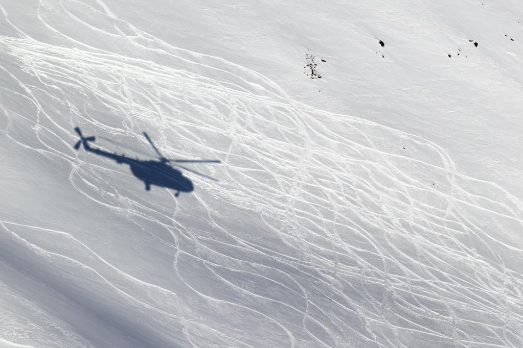
Springtime visitors to the park have kept Lauretig’s team on its toes. In March alone, Joshua Tree Search and Rescue, along with park service rangers and San Bernardino County medics, responded to four separate climbing rescues: one that required a helicopter transport and three others that resulted in ambulance rides to the local hospital.

On April 1, Joshua Tree National Park officially shut down all public access, which will hopefully quiet search and rescue calls for Lauretig’s crew.

“This is definitely not the time to be doing risky things and end up in the emergency room with a broken leg, using up valuable emergency medical resources,” Lauretig said.

An open hatchback on a sport utility vehicle showing ropes and rescue gear inside.
Emergency crews are ready for rescue in the Joshua Tree National Park area.
Photo courtesy of Friends of Joshua Tree

With the park completely shut down, Lauretig said he hopes visitor traffic in the park’s gateway towns of Twentynine Palms, Yucca Valley, and Joshua Tree dissipates. And so far it has. Lauretig said the days following the park’s total closure were quiet.

“We really want people to just stay at home now because we don’t want our small town to be affected by COVID-19,” Lauretig said, adding concern that an increased visitor population would strain local medical resources.

Lauretig said he understands the need to get outside but urges people to stick close to home, pick the less popular paths, and go outside at the least popular times of the day.

“Try getting outside in the hours right after dawn and just before dusk when there are less people out,” Lauretig said.

Colorado – Backcountry Skiers Out in Force

A similar situation has unfolded in Colorado, where skiers and snowboarders have been pouring into the state’s mountain zones ever since Colorado’s governor ordered all ski resorts to stop lift service on March 15.

Summit County’s high-elevation peaks, including several of Colorado’s most famous 14ers, are easy access to Denver’s population at only an hour or so drive from downtown. Consequently, trailheads in the area are packed and those crowds are keeping the Summit County Rescue Group, the area’s local search and rescue volunteer organization, at the ready.

Charles Pitman, Mission Coordinator of the Summit County Rescue Group in Colorado said his crew conducted an unofficial survey in late March at one of the busiest trailheads in the county — Quandary Peak. He discovered that half the cars parked at the trailhead were local, from Summit County, and the other half were from the front range, more than an hour’s drive away in the Denver area.

“There have been long discussions about whether this is an appropriate thing to be doing given the order to stay closer to home,” Pitman said. “People should be staying close to their homes, and if there’s no skiing nearby, then they should find something else to do.”

Pitman is also concerned about the lack of space at these crowded trailheads.

“There are 20 to 30 cars in the parking lot and everyone is standing around talking to each other,” he said. “The social distancing aspect is not there.”

A "area closed" sign at a ski resort with a big snow-covered mountain in background.
Ski resorts nationwide stopped lift service in mid-to-late March in an effort to help stop the spread of COVID-19. Here, Big Sky Resort in Montana closed on March 15.

Pitman said they’ve had to change response protocols to comply with social distancing practices to keep their team safe from exposure to the virus. Group briefings at the command center have been nixed and turned into individual briefings conducted outside in the parking lot. Situations in the past where the entire search and rescue team would have been called upon have now been pared down to teams of four-to-eight crew members.

These measures can slow response time, Pitman said.

Pitman said the fewer calls the better right now. Every time search and rescue gets called out, during the pandemic or not, the responders risk injury. Crews being called out during the pandemic now face the added risk of exposure to the Coronavirus. Pitman said he hopes people are willing to self-regulate their conduct and be less risky in the outdoors.

“I’d ask people to pick a more conservative line right now,” Pitman said. “There is no ski patrol out there — we’re the ski patrol.”

Come on folks. Let’s be smart. This is not social distancing. #MayorParker pic.twitter.com/on4ygQauRY

— Mayor Parker The Snow Dog (@officialsnowdog) March 21, 2020
This video is shared with permission by Mayor Parker The Snow Dog @officialsnowdog

Pitman added that in easy-access areas, like Loveland pass, he’s noticing a lot of novice backcountry users. On a recent weekend day, Pitman checked in with dozens of skiers and snowboards at the parking areas at Loveland Pass and discovered that only one was wearing an avalanche beacon.

“Maybe it’s better that people do a little introspection and recognize that these are different times right now, perhaps they need to hang up the snowshoes and the skis and do what the governor said to do, which is stay close to home and don’t get too close to other people,” Pitman said.

Lake Tahoe – Fewer Search and Rescue Volunteers

In some places, COVID-19 has put a strain on the number of volunteers available to respond to search and rescue missions. That has been the case in El Dorado County, California, where the Sheriff’s Office is tasked with responding to search and rescue missions from South Lake Tahoe, over the Sierra crest, and down to the gold rush towns surrounding Placerville, California.

Like most other search and rescue teams in the nation, El Dorado County relies on volunteers to carry out rescue missions. Some volunteer members have become unavailable for call out, El Dorado County Sheriff’s Sgt. Anthony Prencipe said.

“The reality is that there are so many people that are in self-quarantine and that’s affecting how many volunteers we have available,” Prencipe said. “We have less volunteers that are able to respond and go out to calls.“

A shadow of a helicopter on a snow field with ski tracks

Navigating the Line Between Access and Stay-at-Home Orders

When drafting its shelter-in-place orders, many states seem to recognize the benefit that the expanses of public lands bring to its residents.

For example, Colorado’s shelter-in-place order, which took effect on March 26, 2020, mandates that Coloradans take extreme measures to avoid COVID-19 and stay at home with the exception of essential activity, such as buying food or seeking medical care. In a separate document, Colorado’s governor clarified that outdoor activity would be permitted for the health and well being of Colorado residents, including “walking, hiking, nordic skiing, snowshoeing, biking or running” provided such activities adhered to social distance protocols.

Other states, like California and Washington, have signed similar shelter-in-place orders, permitting outdoor access close to home and with social distancing practices. Montana went a step further and permitted access to public lands provided that Montanans refrain from high-risk activities such as backcountry skiing “in a manner inconsistent with avalanche recommendations or in closed terrain.”

Hikers, bikers, climbers, and sightseers seem to face a conundrum as they attempt to navigate the line between complying with government orders and maintaining their physical and mental health by visiting the fresh air and expanses of public land.

All three search and rescue leaders advised that people should still seek to get outside, but they ask that people dial back risky behaviors to reduce the chances of needing rescue in the backcountry.

“No one ever plans to get injured or lost. They don’t expect it to happen, but then it does and we get called out,” Prencipe said. “Maybe now is a good time to avoid backcountry places with a higher danger element for now, and maybe stick to the walking trails by your house.”

April 9, 2020
5 FacebookTwitterLinkedinRedditEmail
Canada Wildfires map overlay
Gaia GPSNew Maps

Always Be Prepared with New Canada Wildfires Overlays

by Corey Buhay September 12, 2019
written by Corey Buhay

Dodge road closures, avoid burn scars, and find views unobscured by smoke using two new Canada wildfire overlays in Gaia GPS. Using official government data, we’ve launched two big updates to bring you up-to-date information about both currently burning and historical wildfires across Canada.

About the Canada Historical Wildfires Overlay

Anytime you’re planning an adventure, it helps to have all possible insight into the terrain ahead. Many maps show vegetation cover, but they often neglect to mention burn zones. Now, you can view areas affected by fire in past years with the Canada Historical Wildfires layer. The layer color-codes burned areas with a red color gradient. Brighter-colored areas indicate more recent burns, while darker shading indicates burns that occurred in the more distant past.

All data for the Canada Historical Wildfires layer is sourced from the Canadian Forest Service.

one example of the canada historical wildfires overlay and corresponding map legend
The legend for the Canada Historical Wildfires overlay. Gradient shading indicates how recent the fire occurred.

About the Current Wildfires Overlay

We’ve also added full Canada coverage to the Current Wildfires layer. The overlay previously contained only active U.S. fires. Bright red shading indicates actively burning wildfires. Use it to predict park and road closures as well as smoke pollution, which can diminish air quality, damage lungs, and conceal both views and landmarks essential to route-finding.

The Current Wildfires overlay derives its data from a variety of official government sources. It’s updated daily as new information is made available by Natural Resources Canada (NRCan), the Province of British Columbia, Alberta Wildfire, and the Government of Saskatchewan.

An ipad display, showing the Current Wildfires overlay in the Gaia GPS app
The Current Wildfires overlay is updated daily as government agencies make new data available.

How to Use the Canada Wildfire Overlays

Both wildfire overlays are available to all Gaia GPS users with a Premium Membership.

Look for the Canada Historical Wildfires overlay either in the Feature/Weather Overlays section or in the Canada section of the map manager. It’s listed as “Wildfires (Canada, Historical)”.

You’ll find the Current Wildfires layer listed as “Wildfires (Current)” in the Feature/Weather Overlays section, as well. Simply tap the green plus-sign next to the overlay to add it to your map.

On iOS devices, you can see the year and name of the fire—in addition to the number of hectares burned—by tapping on any shaded area.


September 12, 2019
0 FacebookTwitterLinkedinRedditEmail
Gaia GPSNew Maps

Pacific Crest Trail Maps Available in Gaia GPS, Starting with Washington

by Corey Buhay March 26, 2019
written by Corey Buhay

In 2017, renowned thru-hiker and mapmaker Lon Cooper (Halfmile) partnered with National Geographic to craft meticulously accurate maps of the Pacific Crest Trail. We’re thrilled to announce that we’ve joined that historic partnership to bring you those same PCT maps in Gaia GPS.

We’re rolling out the maps one state at a time, starting with Washington. The NatGeo Pacific Crest Trail map layer currently details a 10-mile-wide trail corridor of the PCT as it stretches from the Canadian border to the Columbia River. In it, you’ll find everything from labeled terrain features and amenities, to points of interest, annotated mileages, and hand-curated notes from Halfmile’s original maps.

https://blog.gaiagps.com/wp-content/uploads/2019/03/ScreenRecording_01-11-2019-14-07-51.mp4

What is the Pacific Crest Trail?

The PCT traces the spine of the western coastal ranges, carving out a 2,650-mile trail that winds through some of the most storied landscapes of Washington, Oregon, and California. Traditionally, the trail begins at the California/Mexico border and finds its terminus at the Canadian border. In between, it connects desert, volcanic slopes, temperate rainforest, and the rocky alpine crown of the High Sierra.

The PCT was originally conceived of in the 1920s, and has since become the stuff of both American heritage and recent pop culture. Its length and variety makes it ideal for staging day-hikes and section-hikes of any shape and size, in addition to end-to-end hikes. These full-length hikes, called thru-hikes, take most people four to six months to complete. According to the Pacific Crest Trail Association, just 6,636 people have completed the entire trail.

Why National Geographic Maps?

National Geographic consistently sets the standard for quality and accuracy in outdoor recreation mapping. The NatGeo Pacific Crest Trail map is a perfect example. All information is fact-checked and reviewed by long-distance hikers, local land managers, and NatGeo’s own cartographic editing team. The layer also uses a trail-centered map format specially designed for long trails.

This PCT map stands out for its comprehensive campsite coverage. Unlike other maps, this one labels both official and unofficial campsites, and marks over-camped spots. If land managers report that a campsite is heavily impacted by human traffic and no longer recommended for camping, the NatGeo PCT map uses a grayed-out tent icon to indicate discouraged use.

How to Use the NatGeo Pacific Crest Trail Map

The NatGeo Pacific Crest Trail map source is available to any Gaia GPS user with a Premium Membership. To add, simply open the United States category in the map manager. Then tap the plus sign next to the NatGeo PCT map layer. Because NatGeo maps are extremely detailed, we recommend using this one as a primary base map under any of your favorite weather forecasts or feature overlays.

You can find other tips for using Gaia GPS to navigate on thru-hikes and extended backpacking trips here.

More to Come

Keep an eye out for Oregon and California PCT maps, which we plan to add in the coming months. When complete, this will be the second prong of the Triple Crown to be included in the Gaia GPS map catalog. (We added the full NatGeo Appalachian Trail maps in 2018.)

March 26, 2019
0 FacebookTwitterLinkedinRedditEmail
AndroidApp UpdatesCompany NewsGaia GPSHow-ToiOSNew FeaturesNew Maps

New Map Overlay: Explore Canada Trails with Gaia GPS

by Corey Buhay February 6, 2019
written by Corey Buhay

Canada is home to 47 national parks and hundreds of provincial and territorial parks, all crossed and interconnected by world-class trails. Now, you can explore all of them with Gaia GPS.

Thanks to a new trails overlay from award-winning Canadian mapmaker Backroad Mapbooks (BRMB), the Gaia GPS map catalogue includes more detailed coverage of Canada than ever before. Whether you’re planning an expedition to the Arctic Circle, exploring the sky-splitting Canadian Rockies, or taking a day hike outside Montreal, the BRMB Canada Trails Overlay has you covered.

https://blog.gaiagps.com/wp-content/uploads/2019/02/BRMB-Trails-1.mp4

Color Coded for Route Planning at a Glance

The BRMB Canada Trails overlay includes over 70,000 miles of trail, including the country’s well-known behemoth, the 11,635-mile Trans-Canada Trail. All routes are color coded to indicate both their intended use and seasonal availability, making it easy to zero in on the destinations that are right for you.

Part of a Complete Package of Canada Maps

The addition of the BRMB Canada Trails overlay rounds out Gaia GPS’s existing rolodex of Canada maps. That collection includes ESRI World satellite imagery, precise contour line overlays (in both meters and feet), and the Canada Topo base map, in addition to the highly detailed Backroad Mapbooks Canada base map.

Adventurers in British Columbia can also access interactive overlays showing recent wildfires and timber cuts across the province for even more accurate route planning.

Available to Premium Members

The Backroad Mapbooks Trails overlay is available to Gaia GPS users with a Premium Membership both in the app and online at gaiagps.com. We recommend layering it atop the Backroad Mapbooks Canada base map for a complete and encyclopedic picture of the Canadian backcountry.

February 6, 2019
0 FacebookTwitterLinkedinRedditEmail
AdventuresFeaturedGaia GPSHow-To

Winter Hiking: 10 Things to Remember On Your Next Trip

by Corey Buhay January 16, 2019
written by Corey Buhay

Winter hiking might just be the fourth season’s best kept secret. Don’t let a chilly forecast keep you indoors. Learn the facts, and use them to master your gear, fueling, and layering systems. Do that, and you can have just as much fun winter hiking as you would in summer. Honest.

Capitalize on the fourth season’s peace, solitude, and snowy landscapes by remembering these 10 winter hiking tips next time you take on a cold-weather adventure.


1. Hot cocoa is actually a winter safety essential.

Your body needs plenty of water for efficient temperature regulation. When you’re well-hydrated, your blood stays thin, which makes it easier for your heart to pump it through the tiny capillaries in your fingers and toes. If you’ve ever spent time exercising in the cold, you know it can be tough to motivate yourself to stay hydrated when all you’ve got is a half-frozen Nalgene. Instead, pack an insulated bottle with hot tea or cocoa.

Because it’s an effective mood booster and way to coax in some extra calories, cocoa mix is actually a recommended item for many search and rescue kits, and a documented tool for helping winter rescue victims cope in emergencies.

Pro tip: If you do carry a water bottle while winter hiking, remember water freezes from the top-down. Store your bottle upside-down in your pack to keep the lid from freezing shut.


2. There’s no such thing as bad weather—just bad gear.

If you find yourself cold or wet on a day hike, don’t blame the weather: You might just be wearing the wrong things. The biggest step you can take to stay safe and comfortable while winter hiking is to choose the right materials and really dial in your layering system. Wet or sweaty clothes can sap warmth from your skin, and in winter, that can result in hypothermia even in moderate temperatures. To keep yourself warm and dry, opt for plenty of thin layers so you can optimize your body temperature no matter how fast or slow you’re moving.

At the very least, pack a windproof layer, a waterproof shell in case of precipitation, and a fleece or light jacket to go under your shell. Select wool or synthetic materials for everything from your baselayers to your hat, gloves, and socks, and consider adding gaiters to seal out snow and a scarf or Buff to seal in heat. Unlike cotton, wool and synthetics retain warmth even when they’re wet. It’s also smart to pack an insulated “crisis puffy” in case of unexpected drops in temperature, as well as extra gloves or socks on long winter hikes.


3. Batteries die faster in the cold.

If you’re using Gaia GPS to navigate and want to make sure your phone lasts in the cold, keep it in a pocket close to your body to keep the battery warm when it’s not in use. For other electronics, consider using lithium batteries, as they’re lighter, more efficient, and typically perform better in extreme temperatures than alkaline.

(Note: Lithium batteries are a great choice for many uses, but not all. For example, most avalanche beacon manufacturers recommend using alkaline batteries, as a lithium battery’s remaining charge is harder for beacons to measure.)


4. Traction and flotation are essential for safe travel.

You wouldn’t drive on packed snow with summer tires, would you? Think of your winter hiking footwear the same way. If your route carries you across steep slopes, boilerplate, ice, or no-fall zones, consider bringing crampons and an ice axe (and know how to use them). To negotiate packed snow or even just a few slick spots on lower-consequence slopes, consider traction devices for your shoes like Microspikes or Yaktrax, as well as a pair of ski or trekking poles. If the forecast calls more than a few inches of fresh snow, you’ll need flotation, as well: Bring snowshoes or backcountry skis to save yourself some post-holing.


5. Walking through snow will take twice as long.

Traveling through even just a few inches of unpacked snow can increase your energy expenditure by up to 2 to 3 times what you’d need to hike the same trail without snow, and that means hiking slower—think one mile per hour or more. Even with snowshoes, you should budget for a longer and more strenuous day than you’d otherwise have in the summer.

If you’re in a higher latitude, you’ll be even tighter on time due to shorter days. Look up sunrise and sunset times before you plan your hike, set a hard-and-fast turnaround time, and start full-day trips before dawn to make sure you don’t get caught in the dark. (Bring a headlamp just in case.)


6. Frostbite and hypothermia can sneak up on you.

Hypothermia can strike in temperatures as high as 50°F, and many people who get frostbite fail to notice it until it’s too late (it’s easy for numb feet to stay out of sight and out of mind). Know the symptoms before you head out, and bring the right gear to keep your fingers and toes comfortable and safe in the cold.

If you notice you’ve got chilly toes even in thick, waterproof boots, take a look at the fit: Sometimes thick socks can impair circulation just enough to keep hot blood from flowing through. Try thinner socks, or sizing up your boots to accommodate your winter-weights.

Also be sure to keep your feet dry: Long days in wet boots can result in immersion foot, or trench foot, which takes longer to develop than frostbite but can also cause lasting damage if left untreated.


7. Winter navigation is a whole different ball game.

Even familiar trails are bound to look different in winter, either because of snow or just the visual differences of fallen leaves and bare branches. Download maps and routes in Gaia GPS before you head out, just in case. Be sure to reference the Snowfall Forecast overlays, which will show NOAA’s forecasts for snow accumulation up to 72 hours in advance. Always bring a map and compass as backup.


8. On average, temperatures drop 3 to 5°F per 1,000 feet in elevation.

This is a good rule of thumb, and it makes sense: The higher the altitude, the colder the air. However, winter weather can be unpredictable. Check the forecast before you go, and pack for the lows, not the highs. Use a weather resource like mountain-forecast.com, which shows the expected temperatures and wind speeds at the tops of mountains as well as at the bottom. If you can’t find a detailed elevation forecast for your area, do some rough math: If it’s 40°F at the trailhead and your hike’s high point is 2,000 feet above that, make sure you have layers to keep you warm down to 30°F.


9. Snow can reflect up to 80% of the sun’s rays.

In most conditions, the worst you’ll come home with is a pretty serious goggle tan. But on sunny days above treeline, all that reflected light can cause serious sunburns and even snow blindness, a type of UV damage to the eyes that can impair vision for up to several days after exposure. Wear sunscreen, UV-blocking chapstick, and polarized shades or glacier glasses with full coverage.


10. Quick-burning carbs warm you up the fastest.

Constantly adding fuel to the furnace is one of the best ways to stay warm in the winter. Carbohydrates metabolize the fastest, giving you a quick burst of energy and warmth. Munch on high-carb snacks like potato chips, crackers, and candy bars throughout the day. Mix in high-fat foods like nuts, chocolate, summer sausage, and cheese, which provide more consistent, slow-burning energy.

Whatever you bring, make sure it resists freezing and is easy to eat on the go. And make sure it tastes good: Winter hiking should be fun, and it’s hard not to have fun when there’s chocolate involved.


January 16, 2019
0 FacebookTwitterLinkedinRedditEmail
AndroidApp UpdatesFeaturedGaia GPSHuntingiOSNew FeaturesNew Maps

Streamline Your Navigation with the Satellite Topo Base Map

by Corey Buhay December 13, 2018
written by Corey Buhay

Combine the best features of the Gaia Topo base map with ESRI world satellite imagery on a single, easy-to-use layer. Ideal for everything from planning backcountry ski tours to scouting off-trail routes up desert washes, the new Satellite Topo map promises to become Gaia GPS’s most versatile base map yet.

The seamless marriage of satellite imagery and clear contour lines gives backcountry skiers an accurate picture of avalanche slide paths, and lets backpackers and overlanders view tree cover and slope steepness for easier campsite scouting. The combination also illuminates terrain obstacles for both climbers and hikers, making it easier to find descents and reroutes, devise new linkups, and formulate emergency exit strategies on the fly. No matter what you do, the Satellite Topo map will leave you better informed and better prepared.

https://blog.gaiagps.com/wp-content/uploads/2018/12/SATTopo.mp4

What is the Satellite Topo Map?

Satellite Topo is a base map designed to combine the popular way-finding features of Gaia Topo with a high-resolution picture of the landscape. To achieve that, Gaia GPS removed the plain background from Gaia Topo. We then replaced it with high-resolution imagery from ESRI, an international supplier of geographical information and satellite photography.

The result is a network of clearly marked roads and trails, labeled terrain features, and distinct contour lines (all sourced from OpenStreetMap data) on a background that perfectly resembles the world around you. Essentially, the combination streamlines your navigational workflow by bringing the map one step closer to your reality.

How to Use it

The Satellite Topo base map is available in two versions: meters and feet. It’s accessible to Premium Members on iOS and Android platforms as well as on gaiagps.com. To use it, follow these steps:

  1. Open the Layers Menu and navigate to the Satellite Imagery catgory.
  2. Click the plus sign next to the Satellite Topo map in your preferred unit of measurement to turn it on.
  3. Slip the map beneath any of your favorite overlays in place of your existing base map.
December 13, 2018
0 FacebookTwitterLinkedinRedditEmail
Gaia GPS

Use Your GPS Tracks to Update OpenStreetMap

by Kate Dougherty September 14, 2015
written by Kate Dougherty

In a recent blog post, we showed you how to join OpenStreetMap and help build an open map of the world, alongside millions of other map editors. That post focused on editing the map by comparing it to aerial imagery.

This new article covers how to use your GPS recordings (such as those you might make in Gaia GPS), to edit roads, landmarks, and other information into the map. Remember, OpenStreetMap doesn’t just mean roads – it includes trails and everything else of interest to hikers.

Record GPS Tracks and Waypoints

First, you need to go take a hike or something similar, and record tracks and waypoints. With Gaia GPS:

    • Download maps (iOS/Android) of the area you plan to explore ahead of time so they’ll be available without a strong internet connection. 
    • Start recording (iOS/Android) your track. 
    • It’s easy to add photos along your route (iOS/Android); the app will automatically geolocate or “attach” them at the proper locations. 
    • After you’ve finished recording your track, you’ll see a waypoint pin at the location where the photo was taken. Simply tap the pin to see your photo.
    • You can use your photos to contribute to OSM too, but we’ll leave that for another post.

        Completing Your GPS Track

        Once you’ve finished recording your track, you’ll have the option to customize its name (iOS/Android) and add it a folder (iOS/Android). If it’s one of several trails you plan to hike in Yosemite, for example, touch the folder icon to add the track to a new “Yosemite” folder.

        Gaia GPS will save your track and edits automatically, so there’s no save button on this screen. When finished, use your Android’s built-in back or undo button or tap done on an iOS device to exit the window and go back to your map.

          • Next, export the GPX file for your track. You can do this from within the app (iOS/Android), or by downloading the file from GaiaGPS.com. By default, your data will sync to gaiagps.com anytime you launch the app when connected to the internet.

        Uploading Your GPS Track to OpenStreetMap

        While OSM won’t automatically convert your track into a trace on the map, contributors can use it as a guide to add it manually. You can either trace over the path yourself, or make it public so other editors can access it.

          • Log into OpenStreetMap at http://www.openstreetmap.org.
            • Click GPS Traces at the top of the screen. You’ll see a list of the most recently uploaded traces.
              • Click Upload a trace at the top of the screen.

        Openstreetmap, gaia gpsClick on GPS Traces at the top of the screen to upload your file to OSM.

        openstreetmap, gaia gps

        You’ll see a list of the most recently added traces. Click Upload a trace to add yours.

          • On the next page, browse to select the location of the GPX file on your computer. You can also include a description, add tags, and set its visibility to Public. Click what does this mean? next to the visibility drop-down for more information on visibility types.
            • Click upload (the upload button is hidden by the dropdown in the screenshot below).

        openstreetmap, gaiagpsSelect and describe your file, then set its visibility.

        You’ll receive a confirmation of your submission, and a message saying that you’ll be notified by email once it’s been added to the OSM database. This usually happens within a few minutes. When you receive the email, click on the link to see the OSM page for your trace.

        openstreetmap, gaiagpsYour track’s page on OSM. Click edit to start editing the map at that location.

        Using Your Trace to Edit OpenStreetMap

          • Next, click edit to view your track superimposed over aerial imagery within the default editor. The track is so detailed that it may seem difficult to trace. But not to worry – OSM actually has three editors. One of them, Potlatch, will automatically smooth out and simplify the line.
            • To view and edit your trace in Potlatch, click the down arrow next to the Edit button at the top of the screen, then select Edit with Potlatch 2 (in-browser editor). You can also follow these steps to access Potlatch directly from your file’s OSM home page.

        openstreetmap, gaiagpsYour track is superimposed on top of imagery in the default OSM editor.

        While Potlatch looks different from the default editor, it works in much the same way. OSM displays basic instructions at the bottom of the screen.

        openstreetmap, gaiagps

        The trace is simplified in the Potlatch 2 editor.

        Simply click on a blank (unmapped) area of the map to start drawing a new way. Since your trace isn’t officially part of the map yet, OSM considers it a blank space.

          • Click on your track’s starting point to begin tracing over it, and click to add nodes where it begins to turn. The Potlatch editor makes this process much easier. Since Potlatch smoothes out your track, you’ll need fewer nods and less time to trace it.
        openstreetmap, gaiagps

        Follow your track to add it to the map as a new feature.

          • When you’re finished tracing, press enter on your keyboard (or double-click on the last node).
            • Next, you’ll need to add tags on the left. While the left panel may seem a bit crowded and complex when compared to the default editor, the idea is the same, except that Potlatch uses icons to offer a quicker, more visual way to tag features.
              • Set the feature type. Click Unknown, then choose Paths, then Footpath.
        openstreemap, gaiagps

        Tag the new feature.

        There are several tabs in the left pane; the first two are the most relevant to my path through Ringing Rocks Park.

          • After adding basic information on the first tab, click on the second tab and add a tag for the Surface field. In the example below, I’ve tagged the trail as an unpaved surface.
        openstreetmap, gaiagps
              • Feel free to explore the remaining tabs and add more information.
                • Click the Save button at the top of the screen to save your edits.
                  • You’ll be prompted to add a description of your edits for the community. For example, I wrote: “Added the trail/footpath that goes through Ringing Rocks Park.”
                    • Be sure to tweet or Facebook your edits to get your friends mapping too.

        Check back a bit later, and voila, your travels are now on the map for all to see!

        image (6)

        Your track is now mapped and visible to millions of users.

        Learn More about Uploading GPS Traces to OpenStreetMap

        Recording, uploading, and using your GPS tracks to contribute to OpenStreetMap is really quite simple and fun. You may just find yourself wanting to know more. Here are a few resources:

            • OpenStreetMap Wiki: Uploading GPS Traces
            • OpenStreetMap Wiki: Upload GPS Tracks
            • Potlatch 2 Primer: Creating Features

        We’re looking forward to seeing your traces on OpenStreetMap!


        September 14, 2015
        0 FacebookTwitterLinkedinRedditEmail
        Gaia GPSHow-To

        Free Data Sync in Gaia GPS

        by Staff Reports July 20, 2015
        written by Staff Reports

        About half of the people who use Gaia GPS enable the free data sync in the app. We used to call this service “GaiaCloud,” but now we just say the app lets you “sync with gaiagps.com.” This blog post will tell you why and how to sync.

        You should sync, because syncing lets you:

        • Automatically back up your data
        • Use your data on multiple devices, and on gaiagps.com
        • Publish and share your trips
        • Archive data to save space

        Automatically Back Up Your Data

        When you get a new device, upgrade, (or drop your phone in a river), it’s great to know you can simply log in to Gaia GPS on your new phone, and sync back all of your data.

        And when we say backup, we mean it. Your data exists on your devices, in our live database, and in up-to-the-minute snapshots that we archive. Our backups work, and we’ve had events where our servers go nuts, but we don’t suffer data loss of any kind.

        using gaiagps.com

        After using the sync option, you can view your data on the web

        Sync your Data on Multiple Devices

        Many people use a combination of iPhones, iPads, Androids, and gaiagps.com. Syncing data makes sharing data between devices simple and pleasant, and it’s really great to be able to plan trips on a big screen (iPad or computer), and then just take the phone or small tablet on the trip.

        sync from the ipad

        Plot a route on your tablet and sync to your mobile device

        Publish and share your trips

        When you publish a track, others will be able to view your track page and download the GPX file or choose to add it to their online tracks. You can also share your tracks with friends on Facebook and Twitter.

        You can do this one track at a time, or even auto-publish all of your tracks as you create them. Tracks you share get a nice webpage with pictures, stats, graphs, comments, and more.

        sync and view track pages

        View the tracks you sync on the web and share them with friends

        Archive Data to Save Space

        Some power users find they have too many maps and and too much data to keep it all on device conveniently.

        But when you sync, you can keep a digital copy of all of your tracks, waypoints and maps online, and sync them to your device only when you need them.

        If you delete any data from your device, it will automatically archive online, instead of deleting. You can manually toggle the archive settings for each track from your online account. Deleting data from gaiagps.com will also permanently delete it across all devices.

        archive data you sync online

        Archive data online so that it does not sync back to your device

        Free to Use

        You can create your account from the iOS or Android app, or on gaiagps.com. This is totally free, and separate from GaiaPro, a service that gives additional features and maps for the app and website.

        At no cost, you can sync and back up all the data you use in Gaia GPS – trips, routes, imports, photos, maps, waypoints, and even your map source list. You can also use a bunch of great features on gaiagps.com, with or without the app, including the new Trail Finder.

        If you don’t use the service, we’re curious why. Send us a note at support@gaiagps.com

        July 20, 2015
        0 FacebookTwitterLinkedinRedditEmail
        Load More Posts

        Categories

        • Adventures
        • Android
        • App Comparisons
        • App Updates
        • Backcountry Skiing
        • Boating
        • Company News
        • Emergency Response
        • Featured
        • Fishing
        • Gaia GPS
        • Gaia GPS Offroad Podcast
        • GaiaCloud
        • Hikes
        • How-To
        • Hunting
        • iOS
        • New Features
        • New Maps
        • Newsletter
        • Offroading
        • Out and Back Podcast
        • User Profiles

        Recent Posts

        • The Hike Map That Broke Me: How Gaia GPS Turned an Overlander Into a Reluctant Hiker
        • A Fond Farewell to National Geographic Maps — And a Look at What’s Ahead
        • Introducing the Gaia Hike Map: Your Trail-Ready Adventure Buddy
        • Download the app and get a free 14-day trial of Gaia GPS Premium
          • Facebook
          • Twitter
          • Instagram
          • Youtube
          • RSS
          • Explore The Map
          • Get the App
          • Upgrade Today
          • Explore The Map Catalog
          • New Features
            • Gaia GPS

              The Hike Map That Broke Me: How Gaia…

              April 24, 2025

              Gaia GPS

              Introducing the Gaia Hike Map: Your Trail-Ready Adventure…

              March 18, 2025

              Gaia GPS

              Unlock a New Level of Personalization in Gaia…

              December 12, 2024

              Gaia GPS

              Goodbye Clutter, Hello Streamlined Maps: Introducing Sync to…

              November 26, 2024

              Gaia GPS

              Discover Prime Stargazing Locations with Our New Light…

              August 15, 2024

              Gaia GPS

              2023 Mapped: Our Best New Features of the…

              December 27, 2023

              Gaia GPS

              Discover Adventure Easier Than Ever with New Map…

              July 27, 2023

            • New Maps
              • Gaia GPS

                Discover Prime Stargazing Locations with Our New Light…

                August 15, 2024

                Gaia GPS

                Find Prime Viewing for Total Solar Eclipse with…

                March 27, 2024

                Gaia GPS

                See the World More Clearly with New Gaia…

                May 18, 2023

                Gaia GPS

                Gaia Classic: The Only Map You’ll Ever Need?

                May 4, 2023

                Gaia GPS

                Why NatGeo Trails Illustrated are America’s Favorite Maps

                February 9, 2023

                Backcountry Skiing

                Find Backcountry Skiing in Gaia Winter Map

                January 11, 2023

                Gaia GPS

                Our Favorite New Maps and Features

                December 23, 2022

          • Activities
            • Backcountry Skiing
            • Boating
            • Emergency Response
            • Fishing
            • Offroading
          • Adventures
            • User Stories
          • Help

          @2024 - All Right Reserved. Gaia GPS


          Back To Top