

Today, we’re proud to announce the launch of one of our biggest projects yet. A combination of under-the-hood tech and visual design work, the all-new Gaia Topo combines world-class cartography with industry-leading download speeds and sizes.
Click here for instructions to access this map on iOS, the web, or in Android via the public beta.

Gaia Topo before 
Gaia Topo after

World-Class Cartography
This project was driven by map-maker Lee France, who joined the Gaia GPS team this spring as the company’s first full-time cartographer. He brings over a decade of mapping experience to the new Gaia Topo, and early in his career, worked on some of the National Geographic Trails Illustrated Maps you can also access in Gaia GPS. You can read more about Lee’s background on the Gaia GPS team page.
The new Gaia Topo features a cleaner look and smarter labeling. That means it’s both easier to use and more beautiful to look at than ever before. We’ve tuned the map to the needs of many stripes of the outdoor adventurer. A new visual hierarchy system causes national and state parks, peaks, and campgrounds to appear first as you zoom in. We’ve also curated features and polished up the labeling system to improve information density. The result is a map that’s both more aesthetically pleasing and more efficient: It shows you exactly what you need at each zoom level without cluttering up your screen.

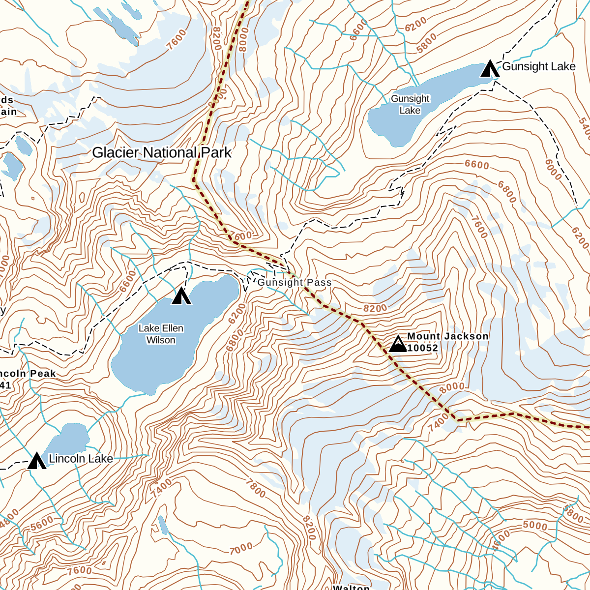
Water labels and contour line styling (before) 
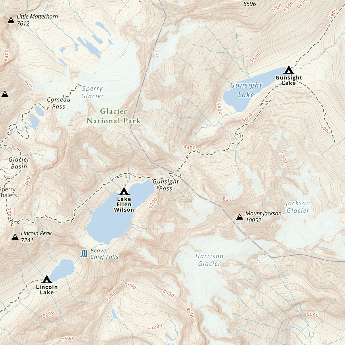
Water labels and contour line styling (now)

Road networks (before) 
Road networks (after)


Road networks and main trails are now easier to find on the map. You’ll also find better hill-shading and toned-down landcover colors that don’t inhibit visibility.
Finally, we’ve improved contour line styling worldwide. Contour lines also appear sooner, making it easier to picture the terrain during large-scale route planning at low zoom levels. We also corrected a number of user-reported issues with the contour lines in various locations around the world.
Faster Downloads, Beautiful Rendering
With the new Gaia Topo, map downloads are faster and take up far less storage space, even though the new map has better data and styling.
To achieve that difference, we combed through all the data contained in Gaia Topo and eliminated redundant information, and did a neat trick to optimize how we packed each little map tile to be stored for offline use. This sort of optimization is something that defines R&D at Gaia GPS, and it’s what keeps our maps on the cutting edge of quality and download speed.
| Download size | Download speed | |||
| Area | Before update | After update | Before update | After update |
| Yellowstone National Park | 63.8 MB | 28.8 MB | 1 min, 33 s | 33 s |
| Washington State | 1.34 GB | 470.8 MB | 28 min, 20 s | 9 min, 21 s |
| Great Smoky Mountains National Park | 42.2MB | 22.8 MB | 33 s | 24 s |
| Adirondack Park | 112.8 MB | 45.2 MB | 3 min, 19 s | 1 min, 8 s |
| Texas | 1.28 GB | 538.2 MB | 1 hr, 2 min | 20 min, 14 s |
Comprehensive Geographic Information
The new Gaia Topo is more thorough and information-rich than ever before, thanks to an expanded roster of data sources. Gaia Topo pulls official government records, crowd-sourced OpenStreetMap information, and existing Gaia GPS data into a living map that constantly updates as new information becomes available.
In addition to comprehensive hiking and camping information, the new Gaia Topo highlights features specific to cyclists, thru-hikers, skiers, anglers, and other more niche categories of adventurer. You’ll find new icons for bicycle parking, ferry routes, beaches, dog parks, hot springs, forest service gates, fishing access points, and backcountry ski huts, to name a few. You can see all new icons in the Gaia Topo map legend.
We’ve also added more ski runs and cross country ski trails, styled to indicate trail difficulty. One-way trails are now marked with small arrow icons.
How to Get the New Gaia Topo
Gaia Topo is the main map source in Gaia GPS, available to all Gaia GPS users—with or without a paid membership.
The new Gaia Topo is now available on iOS, the web, and in the latest beta test version of Gaia GPS for Android. To access it:
- iOS: download the latest version of the Gaia GPS app for iOS
- Android: download the latest version of the Gaia GPS app on Google Play
- gaiagps.com – visit gaiagps.com/map.
If you had previously downloaded maps, you’ll see a notification offering to let you update your downloads.
Map data © OpenStreetMap contributors


")


