Gaia GPS
  • Explore The Map
  • Get the App
  • Upgrade Today
  • Explore The Map Catalog
  • New Features
    • Gaia GPS

      The Hike Map That Broke Me: How Gaia…

      April 24, 2025

      Gaia GPS

      Introducing the Gaia Hike Map

      March 18, 2025

      Gaia GPS

      Unlock a New Level of Personalization in Gaia…

      December 12, 2024

      Gaia GPS

      Goodbye Clutter, Hello Streamlined Maps: Introducing Sync to…

      November 26, 2024

      Gaia GPS

      Discover Prime Stargazing Locations with Our New Light…

      August 15, 2024

      Gaia GPS

      2023 Mapped: Our Best New Features of the…

      December 27, 2023

      Gaia GPS

      Discover Adventure Easier Than Ever with New Map…

      July 27, 2023

    • New Maps
      • Gaia GPS

        Discover Prime Stargazing Locations with Our New Light…

        August 15, 2024

        Gaia GPS

        Find Prime Viewing for Total Solar Eclipse with…

        March 27, 2024

        Gaia GPS

        See the World More Clearly with New Gaia…

        May 18, 2023

        Gaia GPS

        Gaia Classic: The Only Map You’ll Ever Need?

        May 4, 2023

        Gaia GPS

        Why NatGeo Trails Illustrated are America’s Favorite Maps

        February 9, 2023

        Backcountry Skiing

        Find Backcountry Skiing in Gaia Winter Map

        January 11, 2023

        Gaia GPS

        Our Favorite New Maps and Features

        December 23, 2022

  • Activities
    • Backcountry Skiing
    • Boating
    • Emergency Response
    • Fishing
    • Offroading
  • Adventures
    • User Stories
  • Help
Top Posts
The Hike Map That Broke Me: How Gaia...
A Fond Farewell to National Geographic Maps —...
Introducing the Gaia Hike Map
Download the app and get a free 14-day...
Gaia GPS is Improving Satellite Imagery: Saying Goodbye...
How I Used Gaia GPS to Navigate Italy
Gaia GPS x Toyota: A New Way to...
Download Gaia GPS– iOS & Android App
Unlock a New Level of Personalization in Gaia...
Important Update: Changes to Esri World Imagery Offline...
Gaia GPS
  • Explore The Map
  • Get the App
  • Upgrade Today
  • Explore The Map Catalog
  • New Features
    • Gaia GPS

      The Hike Map That Broke Me: How Gaia…

      April 24, 2025

      Gaia GPS

      Introducing the Gaia Hike Map

      March 18, 2025

      Gaia GPS

      Unlock a New Level of Personalization in Gaia…

      December 12, 2024

      Gaia GPS

      Goodbye Clutter, Hello Streamlined Maps: Introducing Sync to…

      November 26, 2024

      Gaia GPS

      Discover Prime Stargazing Locations with Our New Light…

      August 15, 2024

      Gaia GPS

      2023 Mapped: Our Best New Features of the…

      December 27, 2023

      Gaia GPS

      Discover Adventure Easier Than Ever with New Map…

      July 27, 2023

    • New Maps
      • Gaia GPS

        Discover Prime Stargazing Locations with Our New Light…

        August 15, 2024

        Gaia GPS

        Find Prime Viewing for Total Solar Eclipse with…

        March 27, 2024

        Gaia GPS

        See the World More Clearly with New Gaia…

        May 18, 2023

        Gaia GPS

        Gaia Classic: The Only Map You’ll Ever Need?

        May 4, 2023

        Gaia GPS

        Why NatGeo Trails Illustrated are America’s Favorite Maps

        February 9, 2023

        Backcountry Skiing

        Find Backcountry Skiing in Gaia Winter Map

        January 11, 2023

        Gaia GPS

        Our Favorite New Maps and Features

        December 23, 2022

  • Activities
    • Backcountry Skiing
    • Boating
    • Emergency Response
    • Fishing
    • Offroading
  • Adventures
    • User Stories
  • Help
Tag:

avalanche

Two skiers skin up a low-angle snowfield in single file. It's sunny and mountains extend in the distance.
Backcountry SkiingGaia GPSHow-To

How to Use Maps to Help Avoid Avalanches

by Drew Zieff November 27, 2023
written by Drew Zieff

Beyond the boundaries of ski resorts, untouched powder and the promise of adventure beckon skiers, snowboarders, snowmobilers, mountaineers, and hikers into the backcountry. However, traveling in the backcountry is not without risk—25-30 people die in avalanches each year in the United States alone. Last season, an exceptionally weak snowpack in many popular backcountry zones has contributed to an increase in avalanche danger and fatalities.

While avalanches are undoubtedly hazardous, they tend not to occur randomly. Backcountry travelers can largely avoid avalanches with careful route planning and terrain management. This how-to article will point out a few ways that you can use maps as one tool to mitigate risk and help you avoid avalanches.

Traveling in avalanche terrain is an inherently dangerous activity. You should not travel in avalanche terrain until you and your partners undergo avalanche safety training and are competent in the use of avalanche safety gear (beacon, shovel, probe). Maps serve as a supplement to avalanche safety training, not a replacement.

This article covers how to identify avalanche terrain by observing:

  • Aspect and Elevation
  • Topography
  • Terrain Traps
  • Avalanche Paths

A Short Primer on Avalanche Terrain

photo of avalanche with terrain trap beneath it.
Avalanche at Farmington Lakes, Utah. Photo courtesy of Utah Avalanche Center

If you aren’t familiar with identifying avalanche terrain, the Avalanche Canada online terrain identification tutorial is a great place to start. Our article gives you some examples of how you can identify and analyze avalanche terrain on a map. While a map is an important planning tool, keep in mind that it can be hard to completely understand terrain solely from a 2D map. You can supplement your understanding of a route with photographs from guidebooks or online sources like PowderProject and with 3D tools like Google Earth. And, most importantly, continually evaluate terrain as you travel, as subtle details may not be completely conveyed by the map.

Aspect and Elevation

Avalanche hazard often varies by aspect and elevation. Many avalanche forecast centers use an avalanche danger rose to forecast the distribution of the different avalanche problems at different aspects and elevations. The danger rose, in conjunction with your map, is a good place to start when planning a tour. Use the forecast to help you pick a safe objective for the day, rather than choosing a location first.

Here is an example from the Utah Avalanche Center forecast. Below 9500 feet, the avalanche hazard is “low,” a subjective categorization meaning human-triggered and natural avalanches are unlikely. Keep in mind that conditions can change rapidly, avalanche forecasts are imperfect, and accidents and fatalities have occurred on “low” hazard days. Elevation and aspect are only one part of mitigating avalanche risk.

Example of a danger rose for the Salt Lake Area Mountains

Aspect can give you important clues about danger from wind loading and sun exposure. If the winds have been coming from the west, you may be more concerned about wind slabs on easterly aspects. On sunny days, solar radiation can contribute to wet loose avalanches on solar aspects. And, particularly in continental and intermountain snow climates, persistent slabs may be present on all aspects.

When planning your tour, note the elevation on the map by reading the contour intervals and compare it with the danger rose. Or, better yet, create a route and look at the elevation statistics.

Avalanche on the south face of Taylor Mountain, Teton Pass, Wyoming. Photo courtesy of Bridger-Teton Avalanche Center.

Slope Angle

When avalanche expert Bruce Tremper introduces terrain management in his must-read book, Staying Alive in Avalanche Terrain, he leads with a quote from Canadian avalanche specialist Karl Klassen. Klassen says, “The snowpack is a capricious and erratic acquaintance who you never get to know very well. The terrain is a steady and predictable friend that you can always depend on.”

Caveats riddle avalanche textbooks and avalanche safety classes. Snow science has fewer hard rules than backcountry skiers would like, and discussions of slope angle are no different. Avalanches are dynamic, conditions dependent, and can occur on a wide variety of slopes. These inconsistencies demonstrate why terrain management should always be used in conjunction with snowpack evaluations, weather observations, and avalanche forecasts. That said, while by no means a foolproof strategy, backcountry travelers who want to avoid avalanches significantly minimize risk by sticking to slopes under 30°.

Slope Angle and Avalanche Correlation: Because slope steepness directly correlates to avalanche activity, savvy backcountry travelers pay close attention to slope angles. Over 90% of avalanches start on slopes between 30° and 45° degrees. A 30° slope compares to a blue run at a ski area, while 45° slopes are found on double black diamond runs. In other words, prime skiing terrain is also prime avalanche terrain. One key detail is that most avalanches start on slopes between 30° and 45° degrees. Avalanches can be triggered remotely and run into lower angle terrain, so it is important to have a thorough understanding of runout zones.

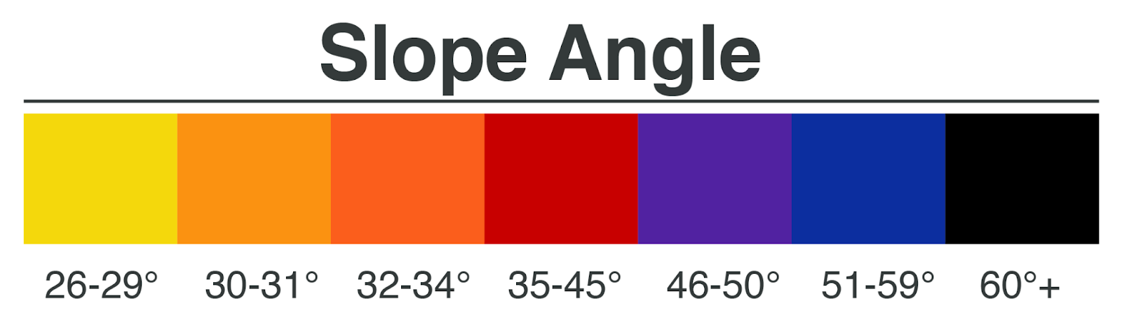
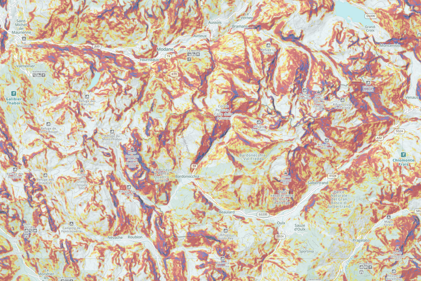
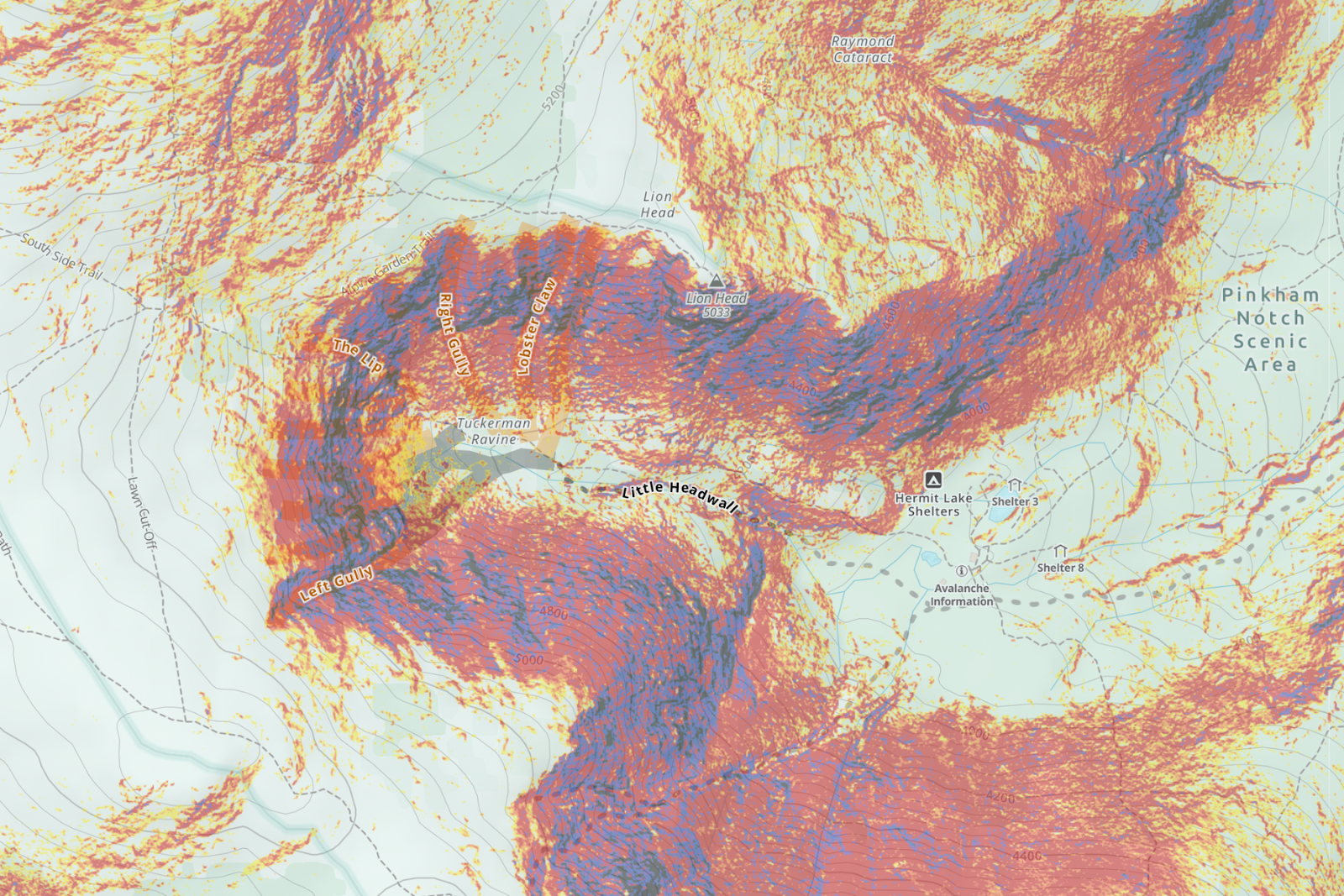
Slope Angle Maps: Gaia GPS’ Slope Angle layer can help you identify avalanche terrain. Slopes are color-coded with their approximate steepness, with orange and red denoting terrain between 30 and 45 degrees.

The Inaccuracy of Slope Angle Maps: Keep in mind, slope shading is only “a depiction of reality.” The map will differ from the actual terrain. Avalanche start zones like convexities or small pockets of steepness can escape detection. The error can be as high as 4 degrees. The difference between 26 and 30 degrees, or 30 and 34 degrees, can be a significant increase in risk exposure – check out this distribution chart of avalanches by start zone slope angle.

In January 2019, a tragic avalanche accident occurred during an avalanche training class in Colorado. One contributing factor was that the slopes the group traveled on were a few degrees steeper than what the slope-shading estimated. To understand more about how nuanced—and impactful—slope-angle readings can be, read the full accident report. For an even deeper discussion, see Jeff Deems’ presentation about how these map overlays are made from the 2019 Colorado Snow and Avalanche Workshop or the article “Digital Mapping: Do You Know What Your Map Knows?” in September 2020 issue of The Avalanche Review.

Additional Tools for Measuring Slope Angle: Slope angle maps are best used for a big picture overview of terrain. To assure that you avoid 30°+ slopes, use a map in conjunction with a hands-on tool, like a slope meter, for a more accurate slope assessment. That said, measuring by hand isn’t infallible either—to get an accurate slope reading with an inclinometer, you may have to expose yourself to the start zone or the slide path.
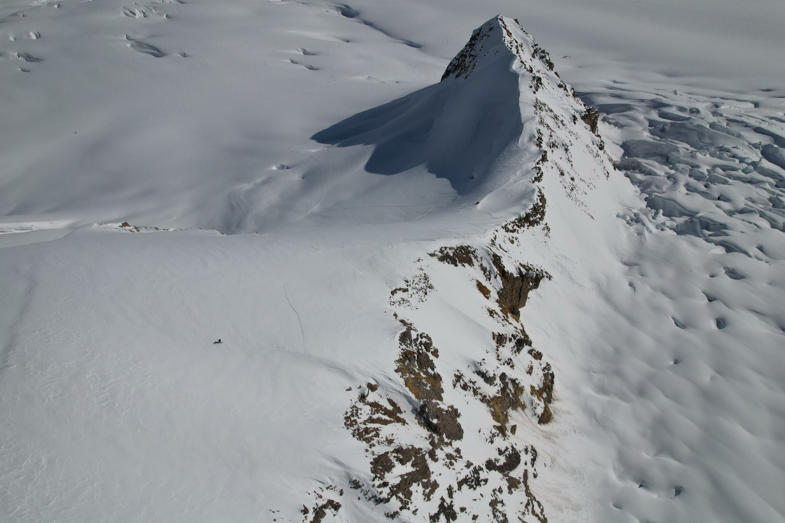
Topography

If you aren’t familiar with reading topographic maps, here is a good primer.

Understanding topography helps differentiate more dangerous, complex terrain from simpler, safer terrain. Identifying start zones, ridges, and gullies can help you choose safe travel routes. Keep in mind that ridges are generally safer places to travel.

Onsite interpretation of terrain
Topo map with slope-angle shading of the area in the photograph. Some example terrain features are identified on the map.

Terrain Traps

Terrain traps magnify the consequences of being caught in an avalanche. Being washed over a cliff or into a stand of trees increases the chance of being injured or killed due to trauma—in addition to the risk of being buried under the snow. Trauma causes up to 30% of avalanche fatalities. Gullies and abrupt transitions to flat zones cause the snow to pile up higher, meaning a victim could be buried more deeply, decreasing the chance of a successful rescue.

Carefully scout your intended line for terrain traps with topo and satellite layers. Cliffs may be visible on satellite layers, and will show up on topo maps as contour lines stacked very close together.

Avalanche Paths

Use satellite layers to identify known avalanches paths that you may want avoid on your tour. While avalanches can happen in a wide variety of terrain, satellite maps often reveal signs of obvious avalanche paths including open slopes, sparse trees, and funnel-shaped terrain.

Utilize the Satellite Topo layer to help identify ridges and drainages, which are sometimes confusing on satellite images.

After identifying an avalanche path, it’s important to have a clear understanding of avalanche runout angles. While start zones are generally over 30°, the momentum of a slide may carry avalanche debris down gentle slopes, across flat expanses, and even up inclines, so be sure to give yourself adequate distance from the path. Keep in mind that in very unstable conditions, avalanche paths might exceed the normal runout—taking out old trees or buildings and redefining the path.

Supplement your analysis of avalanche paths with data and maps from avalanchemapping.org, which provides an atlas of common avalanche paths in popular backcountry skiing areas.

Key points to keep in mind before you venture into avalanche terrain:

  • Get avalanche safety gear. Practice sufficiently with your beacon, shovel, and probe before you head into the field.
  • Get proper training. Using maps is a supplement to education, not a replacement. Visit avalanche.org to find an avalanche education course. Start with the free avalanche awareness and education series “Know Before You Go.”
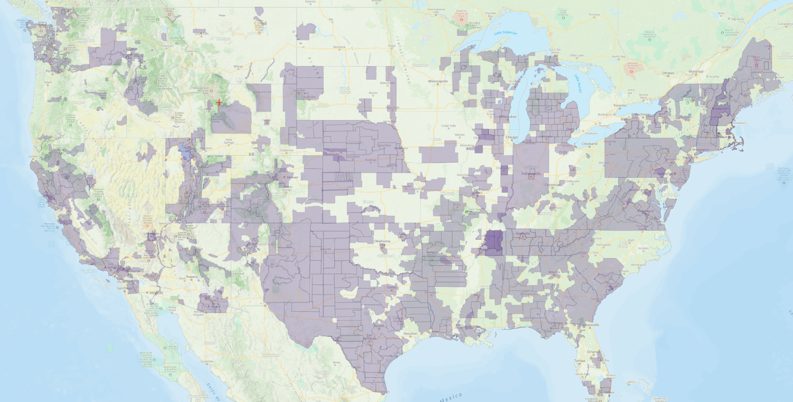
  • Read the avalanche forecast. From Colorado to Utah, Montana to Alaska, avalanche centers provide detailed local forecasts that outline aspects of concern and relevant avalanche problems. When you are online or within cell range, you can use the Avalanche Forecast layer to access the detailed local forecast. Pull up the map to see what the danger rating is for the area you plan to ski that day. From the Avalanche Forecast map, click on the shaded area to be able to access a link that will take you directly to the local avalanche center’s website for more information. Be sure to read the entire forecast from the avalanche center from the link provided on the map.
  • Supplement the weather forecast with Snow Forecast overlays to see what snow is expected to roll in during your ski tour. Check the Snow Stations (Daily) map before your trip to get a daily report on the amount of new snow that has fallen in the last 24 hours and what the average water density reading is for the new snow in the area you plan to visit.
  • Always travel with a trustworthy partner. Beacon, shovel, and probe are useless if you don’t travel with a partner who knows how to use them.

Gaia GPS Pro Tip: Plan routes at home
Planning routes at home is always a smart idea: you can use the desktop version of Gaia GPS, create routes or import tracks from a friend, and print out maps just in case your phone dies when you’re in the field. You can also plot decision points, make backup plans, and determine exit strategies. For more on backcountry route planning, click here.

Contributors to this post include:

Drew Zieff is a freelance journalist and writer and the snowboard test director at Backcountry and Outside Magazine.
Jim Margolis is a Gaia GPS Support specialist and former instructor, program supervisor, and field staffing coordinator at NOLS
November 27, 2023
6 FacebookTwitterLinkedinRedditEmail
slope angle shading on a 3d map
Gaia GPSNew Maps

Spy Avalanche Terrain with Higher Res Slope Angle Map

by Abby Levene December 14, 2022
written by Abby Levene

Scout avalanche terrain easier than ever before. We’ve updated our Slope Angle map with the latest highest resolution 1-meter LIDAR DEM data from the USGS. This data is the gold standard for slope angle shading, rendering our Slope Angle map crisper and clearer for your winter adventures.

Gaia GPS users primarily use our Slope Angle map in winter to avoid avalanche-prone terrain. But hikers, mountaineers, and bikepackers use it year-round to find the easiest path over mountain passes. Photographers and adventurers turn to this map to find unique rock features and waterfalls. Whatever your objective and mode of travel, you can now enjoy the highest resolution slope angle data, wherever it’s available. 

Meet the Slope Angle Gold Standard: Lidar

Last year, we developed our Slope Angle map in-house and tapped into the US Geological Survey’s 3D Elevation Program and NASA’s Digital Elevation Model. These sources allowed us to expand our coverage globally, integrate high-resolution data, and fine-tune color details.

Now we’ve updated the map even further with the best data available on the planet: LIDAR DEM. Harnessing a laser scanner, Global Positioning System (GPS), and Inertial Navigation System (INS), Light Detection and Ranging (lidar) technology produces high-resolution models of ground elevation within an accuracy of 10 centimeters, or four inches. This means our Slope Angle map contains more accurate data than ever before while also pulling out more of those smaller terrain details that can be easy to miss.

Lidar Coverage Continues to Spread Across the US

The updated Slope Angle map uses the latest lidar data wherever it’s available. Check out the map above for a full view of lidar coverage. As you can see on the map, avalanche-prone regions in the northeast, California, and the Pacific Northwest enjoy excellent lidar coverage. 

We’re still waiting for the USGS to supply full lidar coverage of the mountain west. The USGS hopes to complete its collection of lidar data for all of the U.S. and its territories soon; see the status map. Thanks to its high cloud cover and remoteness, Alaska uses Interferometric Synthetic Aperture Radar (IfSAR) instead.

Graded Color Style Picks up the Details

A continuous color ramp shows terrain changes in a graded fashion, making terrain features a snap to read on the map.

The map emphasizes 30 to 45-degree zones in orange and red colors, recognizing and calling your attention to the fact that these slopes comprise the starting zone for most avalanches. Less steep terrain—in the 20 to 25-degree range—is highlighted in green. Slopes steeper than 45 degrees are shaded in greyscale colors to point out the steepest terrain on the map. The grey shading also helps people with red/green confusion color blindness see the map details.

Identify Avalanche Terrain Worldwide 

While LIDAR DEM does not cover the entire US, our Slope Angle map continues to provide not just country-wide, but also worldwide coverage using the highest quality data available from the US Geological Survey’s 3D Elevation Program and NASA’s Digital Elevation Model. 

Whether you’re backcountry skiing the bowls or snowmobiling deep into the forest, add the Slope Angle layer to your favorite global base map like Gaia Winter or Satellite Imagery to help plan safer winter routes through the backcountry.

Keep in mind that you can tweak the opacity of the Slope Angle overlay to your needs. Turn the opacity down to reveal underlying terrain details, or dial it up to more clearly view slope steepness. 

Warnings and Limitations

Avalanche forecasting uses many tools to analyze avalanche risk in the field. Slope shading is best used for a big-picture overview of terrain. All slope angle maps, including the updated Slope Angle layer, fail to show micro terrain such as small starting zones. Snow features like wind pillows and cornices will not be on the map.

Be prepared to use an inclinometer and other on-the-ground assessments in the field in addition to the slope angle map. Change your plans accordingly if the terrain does not match up to the data depicted on the slope angle layer.

Educate yourself about avalanche and snow safety before traveling in any areas prone to avalanches. For more information on how slope angle maps are made, see Jeff Deems’ presentation about how these map overlays are made from the 2019 Colorado Snow and Avalanche Workshop or the article “Digital Mapping: Do You Know What Your Map Knows?” in September 2020 issue of The Avalanche Review.

How to Get the Slope Angle Map

The Slope Angle layer is available with a Gaia GPS premium membership. To access the layer, visit the layers menu, and select the “Features/Weather Overlays” tab. Scroll down and tap “Slope Angle.” Tap the “Add Layer“ button. Learn how to add and manage overlays here. 

Pair this map with other useful backcountry skiing maps available with a Premium membership on Gaia GPS. Read up on how to use maps, including the slope angle layer, to help avoid avalanche danger. 

December 14, 2022
1 FacebookTwitterLinkedinRedditEmail
two skiers on top of a snow ridge with mountains in the background
AdventuresBackcountry SkiingGaia GPSHow-ToOut and Back Podcast

How to Avoid Another Deadly Avalanche Season

by Mary Cochenour January 21, 2022
written by Mary Cochenour

How to listen: iTunes | Google Podcasts | Spotify | Stitcher | Pocket Casts | RadioPublic | Breaker | Castbox

Avalanches killed 37 people in the U.S. last winter, making it the most deadly season in modern history. Why was 2020-2021 so dangerous and how can we avoid avalanches this winter? Get the answers to these burning questions in our new winter safety series, dropping on the Out and Back podcast today.

In this four-part series, avalanche forecasters expose the factors that played into last season’s tragic fatalities. Tune in to hear the details of one of the most chilling avalanche accidents in Utah’s history. Learn how seasoned ski mountaineers make the tough decision to turn around just shy of the summit. And get a crash course on how to read an avalanche forecast so you can be plan safer routes on your next tour.

Listen to all four binge-worthy episodes at once, or pick them up in a random order. However you listen — don’t delay. Each episode gives you real, actionable insights that you can put to use in your next winter adventure.

Get 40% Off Gaia GPS Premium

Episode 43: How Last Winter Became the Deadliest Avalanche Season of All Time

Last winter was nothing short of a perfect storm. A dangerously weak snowpack plagued the entire nation. At the same time, people were hungrier than ever for fresh air and fun. This deadly combination clouded people’s judgment and put them at greater risk, says Ethan Greene, Director of the Colorado Avalanche Information Center.

“Part of what we saw last year, I think, was that we were all living in a difficult environment,” Greene says. “And that made it hard going to the grocery store. It made it hard going to school. It made work hard. And when we had time away from those stresses and got to go into the mountains, it made making decisions in avalanche terrain difficult.”

Director of the Colorado Avalanche Information Center Ethan Greene, PhD.

The unusual circumstances also brought with it surprising demographics. Greene distills the statistics to tell us what age group, gender, and experience level was most at-risk for getting caught in an avalanche last year. Plus, Greene takes a look at they way conditions are stacking up for this season. Don’t get your hopes up. This season could be shaping up to be just as dangerous as the last.

Episode 44: Lessons from Utah’s Wilson Glade Avalanche

Last February, two separate backcountry ski parties headed out for what they thought was lower-angle, safer terrain in the Wilson Glade area of Utah’s Wasatch Mountains. The avalanche risk was high that day, but the two parties were prepared. They studied the avalanche forecast, made conservative travel plans, and carried all the right safety gear into the mountains. But, precautions aside, the skiers were swept away in a colossal avalanche. Four of eight people died.

What went wrong?

Avalanche Forecaster Nikki Champion of the Utah Avalanche Center, investigated the accident. She gives her best insights on the lessons that can be gleaned from this tragic incident.

Avalanche Forecaster Nikki Champion of the Utah Avalanche Center

“I think this accident really hit home with a lot of backcountry users,” Champion says. “Because it was a lot of decisions that most of us could see ourselves making: being in lower-angle terrain, traveling one at a time, skiing the slope multiple times, and not seeing any obvious red flags in that area.”

Champion walks us through what we can learn from this tragic accident. Learn about how to spot and avoid connected terrain. She enlightens us on the dangers of uphill travel. Plus, hear how one survivor’s quick thinking and rescue skills saved the lives of others.

Slope angles in the area of the Wilson Glade avalanche range from 40 degrees to 23 degrees.

Episode 45: Avoiding Summit Fever with Ski Mountaineers Luke Smithwick and Iain Kuo

In the fall of 2021, ski mountaineers Luke Smithwick and Iain Kuo attempted an unsupported, first ski descent of the world’s seventh tallest peak — Mount Dhualagiri in Nepal. They spent weeks advancing to the mountain’s 26,705-foot summit, but high winds and increasing avalanche danger held them back from the top. After months of planning and training, Smithwick and Kuo were forced to retreat, leaving the ski record on the table for another day.

The decision to turn around didn’t come easy for Smithwick and Kuo. But sticking with an objective mindset helped them stave off summit fever. Their number one tip for making good decisions in the mountains? Erase any assumption of how things will play out.

“I have zero expectations going into the mountains,” Smithwick says. “I’m like, wow, the car started, we’re leaving town. Great. Let’s celebrate that. Okay guys, everyone celebrate.”

Ski mountaineer Luke Smithwick on the shoulder of Mt. Dhualagiri — the world’s 7th highest peak. Photo by: Iain Kuo

Smithwick and Kuo review their decision to turn around just shy of Dhualagiri’s unusually harsh and exposed summit. They check their decision-making process and their egos against the popular FACETS acronym that is widely taught in Avalanche 1 courses. Tune in to this conversation to learn where Smithwick and Kuo nailed the human factors, along with a few vulnerabilities that they have to constantly work to keep in check.

Episode 46: How to Read the Avalanche Forecast

Checking the avalanche forecast should be at the top of your safety checklist. It predicts the avalanche danger for your favorite zones and give you a heads up on worrisome problems within the snowpack. But how much stock can you really put into the daily avy forecast report?

US Forest Service Avalanche Expert Simon Trautman says avalanche forecasts should be your building block for planning a safe day in the backcountry. However, once your feet are on the snow, the forecast always takes a back seat to your observations in the field.

US Forest Service Avalanche Specialist Simon Trautman of avalanche.org

“The whole point behind the avalanche forecast is that they’re a starting point for your daily planning,” Trautman says. “But people need to understand that what they’re doing is providing an expert’s idea of a pattern that exists across the landscape.

“They’re great resources but it’s kind of like a weather forecast. If you get out there and it said no rain and it starts raining on you, you need to reassess and you need to figure out what that means for your plan that day. Do you just continue to have your picnic or do you change plans?”

Tune in as Trautman dissects the avalanche forecast into manageable sections. He teaches us the first things to look at and how to get the most out of the avalanche forecast when planning your next tour.

Episode 20: Avalanche Safety Tips with Bruce Tremper

If you need more ammo in your avalanche safety arsenal, go back and listen to Out and Back’s episode 20 with renown avalanche expert Bruce Tremper. Author of Staying Alive in Avalanche Terrain and Avalanche Essentials, Tremper draws on his 30-plus year career in snow science to give us his masterful tips for avoiding avalanches. His advice is pretty simple: stick to low-angle terrain.

“Whenever there is uncertainty in the snowpack, the terrain is always the answer,” Tremper says. “You can cut your risk in half from going from 39 degrees down to 34 degrees. And you can cut your risk in half once again by going from 34 degrees down to 30 degrees. The handiest tool that you can use in all the world of avalanches is slope steepness.”

Learn Tremper’s low risk safety ritual and get some advice on what to do if the unthinkable happens and you get caught in an avalanche.

Avalanche expert Bruce Tremper, author of the book “Staying Alive in Avalanche Terrain” digs a snow pit in Utah’s remote backcountry.

Episode 21: Buried Alive — Bruce Tremper Tells His Story

It’s almost impossible to grasp the power and force of avalanches, unless of course you’ve actually been caught in one. Avalanche expert Bruce Tremper brings us a little closer to that experience with his story about how he triggered — and was buried in — an avalanche in Montana. He describes the feeling of having the “rug pulled out” from under his skis, being swept down the steep mountain, and what it felt like when the avalanche finally roared to a stop. Go back to episode 21 of the Out and Back podcast to get the blow-by-blow from Tremper on how he survived the avalanche that should have killed him.

Tap into these Avalanche Safety Resources

Visit avalanche.org for safety resources and avalanche forecasts in your area.
Sign up for avalanche awareness and rescue courses with American Institute for Avalanche Research and Education.
Watch the Know Before You Go video to get pumped about avalanche safety.

Consider donating to your local avalanche center so they can keep those avalanche forecasts coming your way!

January 21, 2022
1 FacebookTwitterLinkedinRedditEmail
AndroidApp UpdatesBackcountry SkiingGaia GPSiOSNew Features

Know Before You Go with the Avalanche Forecast Layer

by Mary Cochenour January 20, 2021
written by Mary Cochenour

Gaia GPS is proud to partner with the experts at Avalanche.org to bring you the Avalanche Forecast layer. Now, you can get official, up-to-date avalanche forecasts for mountain zones in the U.S. directly from the map on your phone.

Plan safer winter backcountry travel with quick and easy access to avalanche danger ratings from the National Avalanche Center and the American Avalanche Association. Link to complete avalanche reports from professional snow safety scientists in your region.

Whether you’re backcountry skiing the couloirs or snowmobiling into the back bowls, add this must-have feature to your avalanche safety toolkit. Updated every 30 minutes, this map is available online only. Be sure to check the map before you head out the door or leave cell service.

Avalanche Danger Ratings and Daily Forecasts

The Avalanche Forecast overlays on top of your favorite backcountry map to show you the color-coded North American Avalanche Danger Scale for your region. Crafted by avalanche forecasting experts, the danger scale spans five categories, from low to moderate and all the way through extreme danger, letting you know the risk of potential avalanches on your planned route.

Look for a time and date stamp on the map, showing exactly when the region’s danger rating expires. Tap the shaded areas on the map to access more information, including travel advice and a link to the official forecast from the snow safety scientists at the local avalanche center.

Regions with a daily forecast will show “no rating” until the forecasting center issues the rating for the day. Because winter backcountry conditions change constantly, this layer updates every 30 minutes and is available for online use only. This layer is only active during the avalanche forecast reporting season set by the avalanche centers in the mountain west.

Use the Avalanche Forecast Layer with your Favorite Maps

I computer monitor displaying the avalanche danger rating for an area on the topo map.

Add the Avalanche Forecast layer to your quiver of backcountry ski maps for a more complete picture of winter conditions in the backcountry. Use the layer in conjunction with the newly updated Gaia Topo, the USGS topo map, satellite imagery, Snow Stations (Daily), Snow Depth, and Snow Forecast layers to gather more information and make safer decisions in avalanche terrain.

How to Get the Avalanche Forecast Layer

The new Avalanche Forecast layer is available with a premium membership. To add the layer to your maps, open the Gaia GPS app, tap the layers icon, and select “Add map layers.” Go to “Feature/Weather Overlays” and select Avalanche Forecast.

This feature is available on the Gaia GPS website and both Android and iOS. Download the Gaia GPS app today and start planning your next winter trip to the backcountry.

January 20, 2021
5 FacebookTwitterLinkedinRedditEmail
Gaia GPSNew FeaturesNew Maps

Identify Avalanche Terrain with the New High-Res, Worldwide Slope Angle Map

by Mary Cochenour January 5, 2021
written by Mary Cochenour

Identify avalanche terrain quicker and easier this winter with the Slope Angle map. We brought development of the slope angle overlay in house and tapped into the US Geological Survey’s 3D Elevation Program and NASA’s Digital Elevation Model. These sources allowed us to expand our coverage globally, integrate high-resolution data, and fine-tune color details. These improvements help make picking out steep, avalanche terrain on the map a snap.

Whether you’re backcountry skiing the bowls or snowmobiling deep into the forest, add the Slope Angle layer to your favorite base map to help plan a safer route through the backcountry. If you’ve downloaded slope angle maps in the mobile app before, you will see a notification at the top of the “Saved” tab that will let you update your old maps.

Graded Color Style for Finer Details

A continuous color ramp shows terrain changes in a graded fashion, making the change in terrain easier to read on the map.

The new layer emphasizes 30 to 45-degree zones in orange and red colors, recognizing and calling your attention to the fact that these slopes comprise the starting zone for most avalanches. Less steep terrain — in the 20 to 25-degree range — is highlighted in green. Slopes steeper than 45 degrees are shaded in greyscale colors to point out the steepest terrain on the map. The grey shading also helps people with red/green confusion color blindness see the map details.

High Resolution in the US and Worldwide Coverage

The new Slope Angle layer applies the most up-to-date data to deliver insanely crisp resolution for most areas within the United States. USGS 3D Elevation Program provides the best resolution for parts of the US with LiDAR data at 1 to 3 meters. This high-resolution coverage is expanding and will be updated as the USGS releases it. Other parts of the US are covered by 10 meters of resolution through USGS NED data.

Get 25-meter resolution in Western Europe with EU DEM and 30-meter resolution elsewhere around the globe with NASA’s Digital Elevation Model. The higher resolution shows smaller terrain features that would otherwise be hidden with lower resolution data.

Warning and Limitations

Avalanche forecasting uses many tools to analyze avalanche risk in the field. Slope shading is best used for a big picture overview of terrain. All slope angle maps, including the new Slope Angle layer, fail to show micro terrain such as small starting zones. Snow features like wind pillows and cornices will not be on the map. Be prepared to use an inclinometer and other on-the-ground assessments in the field in addition to the slope angle map. Change your plans accordingly if terrain does not match up to data depicted on the slope angle layer. Educate yourself about avalanche and snow safety before traveling in any areas prone to avalanches. For more information on how slope angle maps are made, see Jeff Deems’ presentation about how these map overlays are made from the 2019 Colorado Snow and Avalanche Workshop or the article “Digital Mapping: Do You Know What Your Map Knows?” in September 2020 issue of The Avalanche Review.

How to Get the Slope Angle Layer

The new Slope Angle layer is available with a Gaia GPS premium membership. To access the layer, visit the layers menu, and select the “Features/Weather Overlays” tab. Scroll down and tap “Slope Angle.” Tap the “Add Layer“ button. Learn how to add and manage overlays here.

Pair this map with other useful backcountry skiing maps available with a Premium membership on Gaia GPS. Read up on how to use maps, including the slope angle layer, to help avoid avalanche danger.

If you’ve downloaded slope angle maps in the mobile app before, you will see a notification at the top of the “Saved” tab that will let you update your old maps.

January 5, 2021
3 FacebookTwitterLinkedinRedditEmail
A plume of snow from an avalanche rises into the sky on a snowy peak.
Gaia GPSOut and Back Podcast

Buried Alive: Bruce Tremper Shares His Avalanche Story

by Mary Cochenour December 21, 2020
written by Mary Cochenour

Photo: Bruce Tremper has photographed some massive avalanches during his career, including this slide off Mt. Timpanogos, Utah, in 2005.

How to listen: iTunes | Google Podcasts | Spotify | Stitcher | Pocket Casts | RadioPublic | Breaker | Castbox

In 1978, Bruce Tremper nearly died in an avalanche. He recounts that harrowing tale on this episode of the Out and Back podcast. Tremper peels back the mystery and unpredictability of avalanches to connect listeners with this very real and imminent backcountry danger. This incident changed the trajectory of Tremper’s life, leading him to become one of the preeminent avalanche experts in the world.

“It just shoved snow everywhere. It goes up your nose, it goes underneath your eyelids, which I would never have imagined. It instantly rips off your hat, your mittens — all that is gone instantly and it goes down your neck. I was just getting an injection molded with all this snow. It’s going everywhere in my underwear, and then I’m tumbling and tumbling and I can’t breathe,” Tremper recounted on the Out and Back podcast.

Alone on the mountain that day, Tremper dug himself out. He vowed to learn everything he could about avalanches after that close brush with death. Tremper went on to study avalanches at Montana State University and worked on the snow safety team at two Montana ski areas. He landed his dream job as an avalanche forecaster in Alaska and then at the Forest Service Utah Avalanche Center, where he spent 29 years in the director’s chair. He’s written three books on the topic of snow science and avalanche safety. Tremper’s most popular book, Staying Alive in Avalanche Terrain, opens with this avalanche accident.

A skier crosses over the remnants of an avalanche slide.

Tune in to hear Tremper tell the story beyond the pages in the book. He gives a blow-by-blow account of what it felt like to have the “rug pulled out” from under his skis and rocket down the hill with a landslide of snow. Tremper shares how after this event, he made unlocking the mysteries of avalanches his number one goal in life.

Hold on tight as Tremper unpacks what should have been a life-ending experience. If you’re looking for more practical tips, go back to last episode where Tremper lays down his best measures for staying safe in the backcountry this winter.

To learn more about avalanches visit avalanche.org, or go to your local avalanche center for area forecasts. Check out Tremper’s “Know Before you Go” video. You can find his books at mountaineers.org.

Episode Highlights:

4:10: Tremper was almost literally born with skis on his feet.
5:15: Skiing is a religious experience for Tremper.
7:20: Tremper got a job in 1978 installing and building the Pierre’s Knob lift at Bridger Bowl, Montana.
9:15: Before the lift opened to the public, Bruce had to ski the line by himself and it was a stormy, snowy day.
10:20: This is the story of how “Tremper’s Run” at Bridger Bowl got its name.
11:00: Tremper made a terrible mistake, “oops I forgot.”
12:10: Tremper decided to cut across an avalanche chute. He thought he could outsmart the avalanche.
13:00: He put his skis on and went zooming across the top of the starting zone.
14:00: The snow fractured 40 feet above Tremper.
15:45: Tremper grabbed onto a tree as he was getting pounded by the avalanche, but lost his grip and went rocketing down the slope.
16:35: He went more than 1,000 feet and snow was everywhere. Tremper couldn’t breathe.
17:35: “I’m going to die.”
18:00: Bruce started swimming for the surface. He started slowing down.
19:20: It felt like concrete.
20:00: Both skis were completely broken.
20:30: This was a huge wake up call to Tremper.
21:44: Tremper was a cocky young kid and green with avalanches — a typical avalanche victim.
22:50: Tremper wanted to know everything about avalanches and he spent his life studying them.
23:45: Tremper is blown away by the overwhelming power of avalanches.
25:00: Avalanches have grabbed ahold of Tremper, and have never let him go.

Last Episode: Avalanche Safety Tips from Expert Bruce Tremper

Bruce Tremper writes in a notebook in a snow put. The tips of his skis and a shovel handle are visible on the bottom of the image.

Bruce Tremper also graced Out and Back with his presence and expertise for the last episode. Here, the renowned avalanche expert dives into the nitty gritty details of snow science and avalanche risk assessment. Author of Staying Alive in Avalanche Terrain and Avalanche Essentials, Tremper gives his hard-won and masterful tips for avalanche safety.

Tremper draws on his 30-plus year career as an avalanche forecaster to give advice on everything from how to spot a weak layer in the snowpack to what to do if you’re caught in an avalanche. If you missed this first installment with Tremper, you’ll want to go back and listen.

Next Episode: Bluebird Backcountry — A Ski Area Without Lifts

Four backcountry skiers skin up a slope outside Steamboat Springs, CO.

In the next episode of the Out and Back podcast, Shanty and Mary catch up with Erik Lambert from Bluebird Backcountry Ski Area. Bluebird Backcountry is a totally new concept — a ski area without lifts. That’s right, alpine touring only. Lambert says he started the Colorado resort as a way for skiers and splitboarders to feel comfortable in their transition from the resort to the backcountry. With ski patrol and avalanche mitigation on site, the new ski area lets people focus on skiing instead of the risks associated with traveling in the wild during winter.

Tune in to the next episode to learn more about what Bluebird offers — everything from top notch backcountry rental equipment, to avalanche courses, to guided backcountry skiing. Bluebird provides a prime spot to get started backcountry skiing and a fun adventure for experts, too.

Meet the Hosts

the host of the podcast Andrew Baldwin wearing an orange hat and blue jacket with a frosty beard, smiling

Andrew “Shanty” Baldwin

In 2019, host Andrew Baldwin completed a southbound thru-hike of the Appalachian Trail. After five months on the trail, Baldwin returned home to pursue a career in voice acting. A friend of the Gaia GPS company, Baldwin was a natural choice for hosting the Out and Back podcast.

In each Out and Back episode, Shanty strives to bring you conversations with people who spend an extraordinary amount of time outdoors. Listen in as Shanty taps into each backcountry expert’s superpower so that you can take their knowledge and experience with you on your next adventure.

Mary smiles while lying down and resting her head on a rock. She's wearing a purple jacket, gloves, and a black buff around her ears.

Mary Cochenour

Mary is the Out and Back podcast producer and a writer and editor at Gaia GPS. Before joining Gaia GPS, Mary worked as a lawyer, newspaper journalist, ski patroller, Grand Canyon river guide, and USFS wilderness ranger.

When she is not in the office, Mary works as a guide for Andrew Skurka Adventures in wild places around the west, like Rocky Mountain National Park, Yosemite, and the Brooks Range in Alaska. See some of Mary’s adventures on Instagram. Also, read her tips on how to plan your first solo backpacking trip and listen to her scary story about being stalked in the wilderness by a sketchy man.

December 21, 2020
2 FacebookTwitterLinkedinRedditEmail
AdventuresFeaturedGaia GPSHow-To

Ski Often, Ski Safe: How to Plan a Backcountry Ski Tour

by Corey Buhay December 7, 2018
written by Corey Buhay

As new snow settles into the couloirs and glades this season, it’s easy to get caught up in the stoke without doing your homework—a potentially fatal mistake when you’re backcountry skiing in avalanche terrain. To get your tour off on the right boot, we teamed up with Joey Thompson, Colorado Mountain School’s Head Mountain Guide as well as a BCA and Hestra ambassador, to put together this must-do, pre-trip checklist.

Skimping on your tour plan comes with high consequences. On average, 27 people lose their lives in avalanches every year in the United States. Even more sobering: Those fatalities include experts, guides, and professionals as well as backcountry skiing novices. The good news is that, while your safety in the mountains is never 100% guaranteed, you can scale your odds overwhelmingly in your favor with the right research and preparation.

Here the ten essential steps you should take to plan any backcountry ski trip.

1. Evaluate your experience level.

The first thing you should do is take a hard look at your overall experience and comfort in the mountains before you get in over your head.

“Overconfidence is a common trap,” Thompson says, and that’s especially true among skiers with only moderate avalanche education. In fact, some studies show that folks with just the first level of avy certification are more likely to expose themselves to undue avalanche risk than any other group.

Getting certified with an avalanche awareness class (like the level 1 course from AIARE, the American Institute for Avalanche Research and Education) is a good first step. However, Thompson warns that years of experience, a lot of practice using a beacon, and good temperament and mountain sense are often more beneficial than formal education alone.

If you’re really new to backcountry skiing—or really obsessing over a descent that might be just outside your comfort zone—consider hiring a guide or finding a mentor with a decade or more of mountain experience to show you the ropes.

2. Check the weather before you pick your route.

Second step: Thompson recommends cross-referencing several weather forecasts before you get your heart set on any particular line.

He checks predictions from the Colorado Avalanche Information Center (CAIC), the National Oceanic and Atmospheric Association (NOAA), and the European weather service MeteoBlue, all of which use different predictive models. For quick reference, map NOAA’s predictions directly over your route plan in Gaia GPS using the Precipitation and Snowfall forecast overlays.

Steer clear of high winds, which can load snow onto leeward slopes; sudden spikes in temperature, which can cause wet slides; and huge dumps of snow, which can build into storm slabs. Also keep an eye on cloud cover, which will flatten the light, making variations in the snow surface tough to distinguish.

If you haven’t already, get a feel for weather patterns in your area. The Pacific Northwest’s snowpack stabilizes much faster than Colorado’s, for example, which means you can start skiing sooner after storms.

3. Select backcountry zones based on the avalanche forecast.

Next, Thompson heads to the local avalanche bulletin and rules out geographic zones, elevations, and aspects with high avalanche risk.

The avy forecast measures risk as a function of both likelihood and size (consequence).

“For example, if you’re skiing in Rocky Mountain National Park in April, you probably have a weak layer [from the thaw-freeze cycles that usually happen in early winter in Colorado] buried really deeply in the snowpack. Maybe it’s dormant—buried too deep to have a high likelihood of getting triggered,” Thompson explains. “But if it does get triggered, all that built-up snow is going to result in an avalanche big enough to sculpt its own landscape and bury a train and houses and condos.” That’s a low-likelihood, high-consequence avalanche.

On the opposite end of the spectrum, a few inches of new snow on short, steep slopes might be really likely to slide, but the avalanches will be much smaller. Those might knock a person off her skis but they’re unlikely to bury anyone completely.

4. Plan your route.

Now that you’ve ruled out the danger zones, evaluate slope angles to find a safe route. Gather beta from friends, online trip reports, and websites like OpenSnow and Wild Snow, and figure out what routes local guides are taking clients on that time of year.

“If you can get your hands on a prerecorded track from a buddy, that’s awesome,” Thompson says, especially if there’s a chance of low-visibility conditions. You can create your own route directly in Gaia GPS, or upload a track from a friend via a KML or GPX file.

Most avalanche educators recommend avoiding slopes between 30 and 45 degrees, especially if the avalanche forecast calls for anything more than low avy danger. (Visualize slope angle along different routes with the Slope-Angle Shading overlay.) However, persistent slab avalanches happen on slopes as low as 22 degrees, so don’t skimp on your weather research.

5. Make a Plan B. 

Prerecorded tracks are great, but any time you’re backcountry skiing, conditions can change fast. Be prepared to tweak or bail on your route at the last minute.

Thompson recommends setting waypoints at decision-making thresholds like headwalls, summits, and higher-consequence slopes to facilitate group discussion about the conditions and terrain.

Always make sure you have a safe escape route in mind. Create plan-B and plan-C tour plans, and download the appropriate maps for offline use.

6. Bring the right maps.

Before you leave service, download maps of the area you plan to explore, along with any routes, tracks, or waypoints to help you find your way. Thompson typically downloads the USGS Topo and NatGeo Illustrated Trails maps. Some other helpful layers:

  • Slope-Angle Shading overlay
  • Shaded Relief overlay, to improve the visibility of slope aspects
  • 24-, 48-, and 72-hour NOAA Snowfall Forecast overlays
  • 24-, 48-, and 72-hour NOAA Precipitation overlays
  • ESRI World Satellite imagery, to visualize tree density and slide paths

Many of these maps are only available with a Premium Membership. Learn more about Premium maps and access them here.

Go Premium

Download multiple map sources, and plan to stash your phone in a chest pocket to keep it warm (cold batteries die faster). Bring paper maps and a compass as backup.

7. Pick your partners wisely.

Going solo in the wild has its allure, but it’s hard to argue with the facts: If you get caught in an avalanche and you’re alone, you’ll have no one to dig you out. Pick partners who share your levels of ambition and risk tolerance, and who you know will be open-minded and communicative with the rest of the group.

Thompson recommends aiming for a group of five. It’s a small enough number for efficient movement and quick decision-making, but big enough that even if two skiers get buried, there are still more diggers than victims.

If you’re a beginner, Thompson suggests skiing with other beginners. They’ll allow you to learn the basics at your own pace in mellow terrain.

8. Get your gear together.

Every group member should have a beacon, probe, and avalanche shovel. Also consider an avalanche pack. They’re expensive, but research shows that when used properly, they can effectively buoy caught skiers above sliding debris.

Put new batteries in your beacon, and securely attach it to your body, either in a chest harness over your baselayer, or clipped to a belt loop and zipped into a pocket. Keep your probe and shovel easily accessible in your pack.

Also throw in plenty of snacks and water. Staying hydrated and frequently consuming carbohydrates will keep you warm and prevent bonking, which can impair your decision-making abilities.

9. Talk with your team the day of the trip.

Discuss turnaround time and goals with your group to make sure everyone’s on the same page. Agree beforehand on what slope angles the group feels comfortable skiing, what weather or snow surface conditions constitute a no-go, and what your plan-B and plan-C options are. Predetermined limits are a good failsafe against succumbing to summit fever in hazardous conditions.

Thompson also suggests designating a team leader before you head out. That way, if something goes wrong, you’ll have enough organizational structure in place to quickly make a plan and avoid infighting.

“It’s really invaluable for beginner skiers to debrief at the end of the day, too,” Thompson adds. “If you skied something outside of your route plan and just got lucky, you’re not going to learn from it if you just slap high-fives all around, get in your car, and drive away without thinking it through.”

10. Do your final checks.

Before you leave, scan the day-of forecast and local avalanche reports. Reconsider your route if you see evidence of avalanche activity on similar slopes in adjacent ranges.

Reading avalanche terrain is an incredibly complex science, Thompson warns: “Even after 25 years of ski touring, I’m just now feeling like I have a handle on it.” So no matter how well you’ve prepared, always double-check your terrain and weather information, and jot down the number for your local Search and Rescue team, just in case.

If all looks good, do a final beacon check, click in, and get after it.

December 7, 2018
0 FacebookTwitterLinkedinRedditEmail
Load More Posts

Categories

  • Adventures
  • Android
  • App Comparisons
  • App Updates
  • Backcountry Skiing
  • Boating
  • Company News
  • Emergency Response
  • Featured
  • Fishing
  • Gaia GPS
  • Gaia GPS Offroad Podcast
  • GaiaCloud
  • Hikes
  • How-To
  • Hunting
  • iOS
  • New Features
  • New Maps
  • Newsletter
  • Offroading
  • Out and Back Podcast
  • User Profiles

Recent Posts

  • The Hike Map That Broke Me: How Gaia GPS Turned an Overlander Into a Reluctant Hiker
  • A Fond Farewell to National Geographic Maps — And a Look at What’s Ahead
  • Introducing the Gaia Hike Map
  • Download the app and get a free 14-day trial of Gaia GPS Premium
    • Facebook
    • Twitter
    • Instagram
    • Youtube
    • RSS
    • Explore The Map
    • Get the App
    • Upgrade Today
    • Explore The Map Catalog
    • New Features
      • Gaia GPS

        The Hike Map That Broke Me: How Gaia…

        April 24, 2025

        Gaia GPS

        Introducing the Gaia Hike Map

        March 18, 2025

        Gaia GPS

        Unlock a New Level of Personalization in Gaia…

        December 12, 2024

        Gaia GPS

        Goodbye Clutter, Hello Streamlined Maps: Introducing Sync to…

        November 26, 2024

        Gaia GPS

        Discover Prime Stargazing Locations with Our New Light…

        August 15, 2024

        Gaia GPS

        2023 Mapped: Our Best New Features of the…

        December 27, 2023

        Gaia GPS

        Discover Adventure Easier Than Ever with New Map…

        July 27, 2023

      • New Maps
        • Gaia GPS

          Discover Prime Stargazing Locations with Our New Light…

          August 15, 2024

          Gaia GPS

          Find Prime Viewing for Total Solar Eclipse with…

          March 27, 2024

          Gaia GPS

          See the World More Clearly with New Gaia…

          May 18, 2023

          Gaia GPS

          Gaia Classic: The Only Map You’ll Ever Need?

          May 4, 2023

          Gaia GPS

          Why NatGeo Trails Illustrated are America’s Favorite Maps

          February 9, 2023

          Backcountry Skiing

          Find Backcountry Skiing in Gaia Winter Map

          January 11, 2023

          Gaia GPS

          Our Favorite New Maps and Features

          December 23, 2022

    • Activities
      • Backcountry Skiing
      • Boating
      • Emergency Response
      • Fishing
      • Offroading
    • Adventures
      • User Stories
    • Help

    @2024 - All Right Reserved. Gaia GPS


    Back To Top