Gaia GPS
  • Explore The Map
  • Get the App
  • Upgrade Today
  • Explore The Map Catalog
  • New Features
    • Gaia GPS

      The Hike Map That Broke Me: How Gaia…

      April 24, 2025

      Gaia GPS

      Introducing the Gaia Hike Map: Your Trail-Ready Adventure…

      March 18, 2025

      Gaia GPS

      Unlock a New Level of Personalization in Gaia…

      December 12, 2024

      Gaia GPS

      Goodbye Clutter, Hello Streamlined Maps: Introducing Sync to…

      November 26, 2024

      Gaia GPS

      Discover Prime Stargazing Locations with Our New Light…

      August 15, 2024

      Gaia GPS

      2023 Mapped: Our Best New Features of the…

      December 27, 2023

      Gaia GPS

      Discover Adventure Easier Than Ever with New Map…

      July 27, 2023

    • New Maps
      • Gaia GPS

        Discover Prime Stargazing Locations with Our New Light…

        August 15, 2024

        Gaia GPS

        Find Prime Viewing for Total Solar Eclipse with…

        March 27, 2024

        Gaia GPS

        See the World More Clearly with New Gaia…

        May 18, 2023

        Gaia GPS

        Gaia Classic: The Only Map You’ll Ever Need?

        May 4, 2023

        Gaia GPS

        Why NatGeo Trails Illustrated are America’s Favorite Maps

        February 9, 2023

        Backcountry Skiing

        Find Backcountry Skiing in Gaia Winter Map

        January 11, 2023

        Gaia GPS

        Our Favorite New Maps and Features

        December 23, 2022

  • Activities
    • Backcountry Skiing
    • Boating
    • Emergency Response
    • Fishing
    • Offroading
  • Adventures
    • User Stories
  • Help
Top Posts
The Hike Map That Broke Me: How Gaia...
A Fond Farewell to National Geographic Maps —...
Introducing the Gaia Hike Map: Your Trail-Ready Adventure...
Download the app and get a free 14-day...
Gaia GPS is Improving Satellite Imagery: Saying Goodbye...
How I Used Gaia GPS to Navigate Italy
Gaia GPS x Toyota: A New Way to...
Download Gaia GPS– iOS & Android App
Unlock a New Level of Personalization in Gaia...
Important Update: Changes to Esri World Imagery Offline...
Gaia GPS
  • Explore The Map
  • Get the App
  • Upgrade Today
  • Explore The Map Catalog
  • New Features
    • Gaia GPS

      The Hike Map That Broke Me: How Gaia…

      April 24, 2025

      Gaia GPS

      Introducing the Gaia Hike Map: Your Trail-Ready Adventure…

      March 18, 2025

      Gaia GPS

      Unlock a New Level of Personalization in Gaia…

      December 12, 2024

      Gaia GPS

      Goodbye Clutter, Hello Streamlined Maps: Introducing Sync to…

      November 26, 2024

      Gaia GPS

      Discover Prime Stargazing Locations with Our New Light…

      August 15, 2024

      Gaia GPS

      2023 Mapped: Our Best New Features of the…

      December 27, 2023

      Gaia GPS

      Discover Adventure Easier Than Ever with New Map…

      July 27, 2023

    • New Maps
      • Gaia GPS

        Discover Prime Stargazing Locations with Our New Light…

        August 15, 2024

        Gaia GPS

        Find Prime Viewing for Total Solar Eclipse with…

        March 27, 2024

        Gaia GPS

        See the World More Clearly with New Gaia…

        May 18, 2023

        Gaia GPS

        Gaia Classic: The Only Map You’ll Ever Need?

        May 4, 2023

        Gaia GPS

        Why NatGeo Trails Illustrated are America’s Favorite Maps

        February 9, 2023

        Backcountry Skiing

        Find Backcountry Skiing in Gaia Winter Map

        January 11, 2023

        Gaia GPS

        Our Favorite New Maps and Features

        December 23, 2022

  • Activities
    • Backcountry Skiing
    • Boating
    • Emergency Response
    • Fishing
    • Offroading
  • Adventures
    • User Stories
  • Help
Tag:

skiing

slope angle shading on a 3d map
Gaia GPSNew Maps

Spy Avalanche Terrain with Higher Res Slope Angle Map

by Abby Levene December 14, 2022
written by Abby Levene

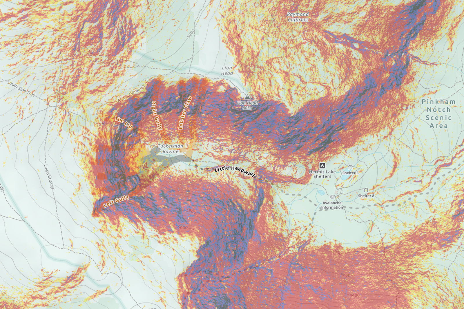
Scout avalanche terrain easier than ever before. We’ve updated our Slope Angle map with the latest highest resolution 1-meter LIDAR DEM data from the USGS. This data is the gold standard for slope angle shading, rendering our Slope Angle map crisper and clearer for your winter adventures.

Gaia GPS users primarily use our Slope Angle map in winter to avoid avalanche-prone terrain. But hikers, mountaineers, and bikepackers use it year-round to find the easiest path over mountain passes. Photographers and adventurers turn to this map to find unique rock features and waterfalls. Whatever your objective and mode of travel, you can now enjoy the highest resolution slope angle data, wherever it’s available. 

Meet the Slope Angle Gold Standard: Lidar

Last year, we developed our Slope Angle map in-house and tapped into the US Geological Survey’s 3D Elevation Program and NASA’s Digital Elevation Model. These sources allowed us to expand our coverage globally, integrate high-resolution data, and fine-tune color details.

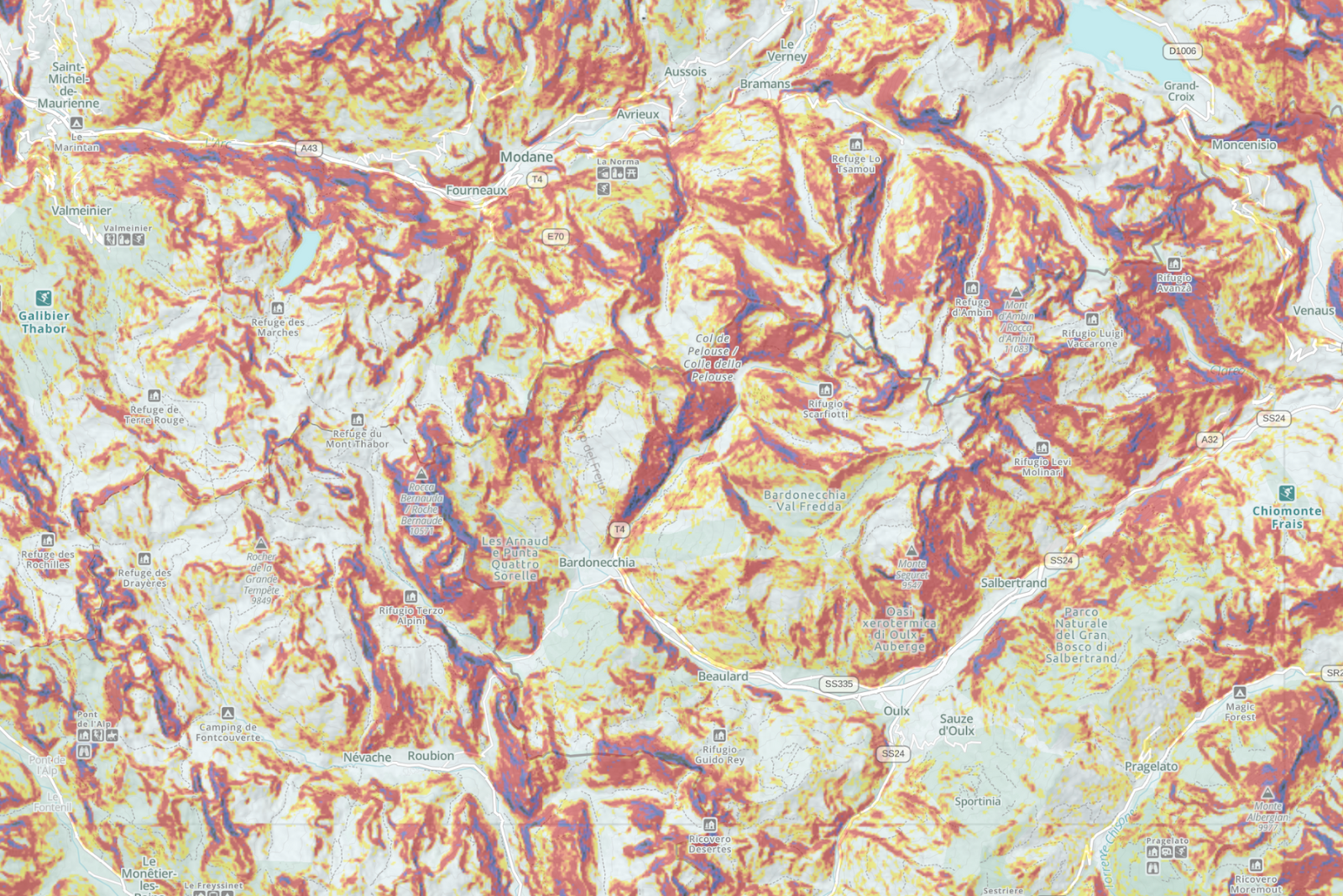
Now we’ve updated the map even further with the best data available on the planet: LIDAR DEM. Harnessing a laser scanner, Global Positioning System (GPS), and Inertial Navigation System (INS), Light Detection and Ranging (lidar) technology produces high-resolution models of ground elevation within an accuracy of 10 centimeters, or four inches. This means our Slope Angle map contains more accurate data than ever before while also pulling out more of those smaller terrain details that can be easy to miss.

Lidar Coverage Continues to Spread Across the US

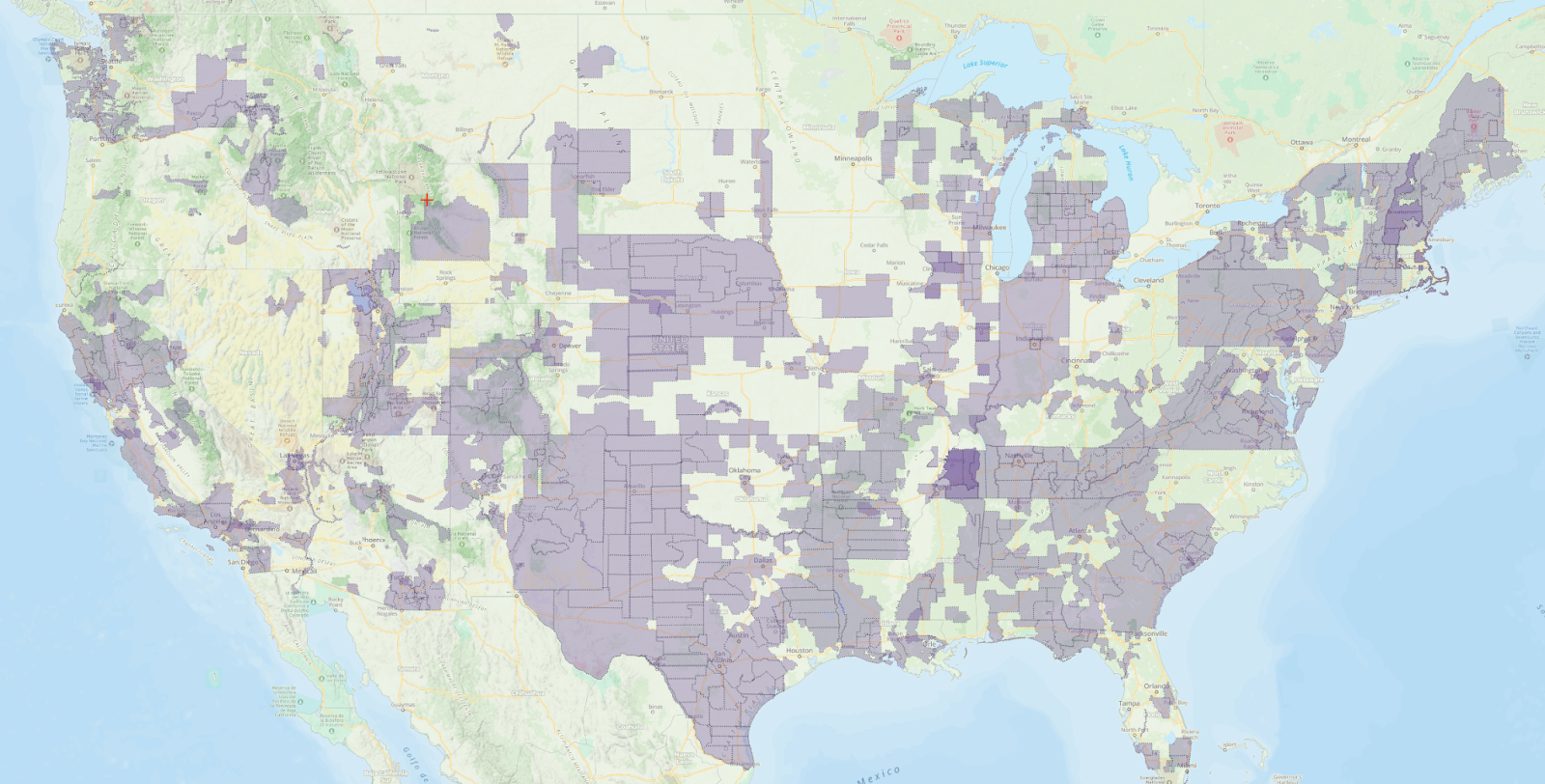
The updated Slope Angle map uses the latest lidar data wherever it’s available. Check out the map above for a full view of lidar coverage. As you can see on the map, avalanche-prone regions in the northeast, California, and the Pacific Northwest enjoy excellent lidar coverage. 

We’re still waiting for the USGS to supply full lidar coverage of the mountain west. The USGS hopes to complete its collection of lidar data for all of the U.S. and its territories soon; see the status map. Thanks to its high cloud cover and remoteness, Alaska uses Interferometric Synthetic Aperture Radar (IfSAR) instead.

Graded Color Style Picks up the Details

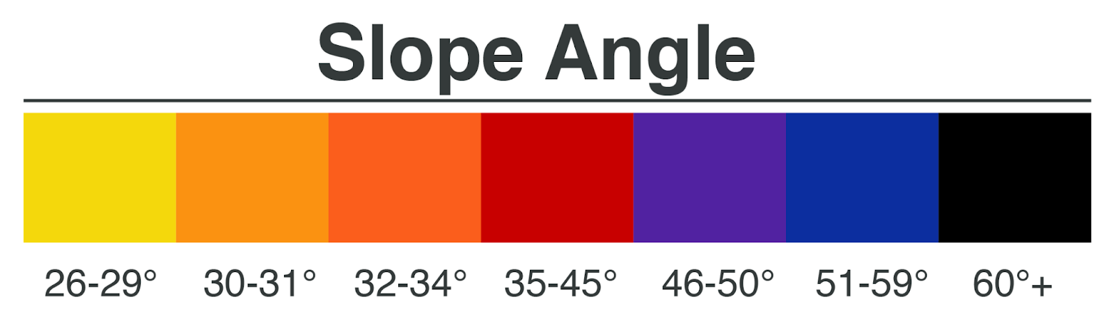
A continuous color ramp shows terrain changes in a graded fashion, making terrain features a snap to read on the map.

The map emphasizes 30 to 45-degree zones in orange and red colors, recognizing and calling your attention to the fact that these slopes comprise the starting zone for most avalanches. Less steep terrain—in the 20 to 25-degree range—is highlighted in green. Slopes steeper than 45 degrees are shaded in greyscale colors to point out the steepest terrain on the map. The grey shading also helps people with red/green confusion color blindness see the map details.

Identify Avalanche Terrain Worldwide 

While LIDAR DEM does not cover the entire US, our Slope Angle map continues to provide not just country-wide, but also worldwide coverage using the highest quality data available from the US Geological Survey’s 3D Elevation Program and NASA’s Digital Elevation Model. 

Whether you’re backcountry skiing the bowls or snowmobiling deep into the forest, add the Slope Angle layer to your favorite global base map like Gaia Winter or Satellite Imagery to help plan safer winter routes through the backcountry.

Keep in mind that you can tweak the opacity of the Slope Angle overlay to your needs. Turn the opacity down to reveal underlying terrain details, or dial it up to more clearly view slope steepness. 

Warnings and Limitations

Avalanche forecasting uses many tools to analyze avalanche risk in the field. Slope shading is best used for a big-picture overview of terrain. All slope angle maps, including the updated Slope Angle layer, fail to show micro terrain such as small starting zones. Snow features like wind pillows and cornices will not be on the map.

Be prepared to use an inclinometer and other on-the-ground assessments in the field in addition to the slope angle map. Change your plans accordingly if the terrain does not match up to the data depicted on the slope angle layer.

Educate yourself about avalanche and snow safety before traveling in any areas prone to avalanches. For more information on how slope angle maps are made, see Jeff Deems’ presentation about how these map overlays are made from the 2019 Colorado Snow and Avalanche Workshop or the article “Digital Mapping: Do You Know What Your Map Knows?” in September 2020 issue of The Avalanche Review.

How to Get the Slope Angle Map

The Slope Angle layer is available with a Gaia GPS premium membership. To access the layer, visit the layers menu, and select the “Features/Weather Overlays” tab. Scroll down and tap “Slope Angle.” Tap the “Add Layer“ button. Learn how to add and manage overlays here. 

Pair this map with other useful backcountry skiing maps available with a Premium membership on Gaia GPS. Read up on how to use maps, including the slope angle layer, to help avoid avalanche danger. 

December 14, 2022
1 FacebookTwitterLinkedinRedditEmail
Screenshot of the Ski Resort Reports map in Gaia GPS.
Gaia GPSNew Maps

Get Worldwide Ski Resort Reports in Gaia GPS

by Abby Levene January 25, 2022
written by Abby Levene

From Aspen to Zermatt, get conditions for ski resorts around the globe in Gaia GPS. Ski areas with fresh snow light up on our brand new Ski Resort Reports map. See snow totals and weather readings. Find out how many trails are open. Even read the resort’s daily report, all right within the app and on gaiagps.com.

Checking the conditions en route to your home hill. Or find the best place to ski in a new area. The Ski Resort Reports map lets you do it all with just a tap.

See the Latest and Most Accurate Ski Resort Conditions

The Ski Resort Reports map layer sources its information from OnTheSnow, a leading database for ski resort reports and conditions worldwide. OnTheSnow taps information from the ski resorts themselves, ensuring you get the latest and most accurate information available.

View Snow Depth and Terrain Status

Ski resorts from around the world can be found in this map overlay. Simply click on a blue skier icon to see the entire ski resort report. You’ll find the ski area’s name and whether it’s open. Discover if it’s a powder day with new snow readings from the last 24 and 72 hours.

Wondering if you need your rock skis? See the snow depth for the base, mid mountain, and the summit. You’ll also see snow depth totals. Plus, get a sense of how big the resort is and how much terrain is open. See the total number of runs and how many of them are currently good to go.

Track Resort Weather including Wind Speed

Dress appropriately thanks to temperature readings at the base and the summit. And see that all-too critical factor in determining your comfort: wind speed. If you’re not into downhill skiing, no problem. Find out if the resort offers nordic skiing right in this map. You’ll also see how many kilometers of trails are groomed for both classic and skate skiing.

Maybe the weather looks iffy and you just want to double check that the resort is open. Or perhaps you’re hemming and hawing over which resort to go to this weekend. Either way, just glance at the Ski Resort Reports map to get the info you need.

Find the Freshies with the Ski Resort Reports Map

No matter where you’re trying to ski in the world, find the closest resorts and the freshest snow with Ski Resort Reports. See ski areas at even the most zoomed out levels on the map to quickly access conditions. Most importantly, find the best snow in one glance: ski areas that have received snow in the past 24 hours glow neon blue on the map.

How to use the Ski Resort Reports Map

Ski Resort Reports is a map overlay. This means it is designed to work in conjunction with one of our base maps. We recommend pairing Ski Resort Reports with Gaia Winter or Gaia Topo. Both of these base maps were designed-in house specifically for your adventures. Gaia Winter shows all the ski resort maps in the US and Canada. Add this map to your arsenal and never get lost on the mountain again.

To use Ski Resort Reports, start by adding Gaia Winter or Gaia Topo as your base map. Add the Ski Resorts Map on top. Now you can see where ski resorts exist all over the world, as signified by the light blue skier icon. Zoom in or click on a skier icon to see the name of the resort.

Tips for Getting Condition Updates in a Snap

To see the snow conditions and daily resort report, click on the skier icon. The info will appear right in the sidebar if you’re on gaiagps.com. There’s one extra step in the app. First, click on the skier icon in the app. The Ski Resort Reports tile will appear as an option in the tap drawer. If you don’t see it, keep scrolling down through the options in the tap drawer. Next, click on the Ski Resort Reports tile to see the snow conditions and resort report.

Still need more info? You’ll find links to the resort’s website, as well as the original report from onthesnow.com.

Pro tip: turn on dark mode in the app to make the ski resorts pop out from the map even more.

Ski Resort Reports is Available with a Premium Membership

The Ski Resort Reports map is available in the Gaia GPS app and on gaiagps.com with a Gaia GPS Premium membership. To access this map, visit the layers menu and search for “Ski Resort Reports.” Or from the layers menu, select “Feature/Weather Overlays.” Scroll down and tap “Ski Resort Reports.” Tap the “Add Layer” button. Learn how to add and manage overlays here.

A Premium Membership also gives you access to Gaia GPS’s entire map catalog, including Gaia Winter and a suite of avalanche safety maps such as Slope Angle, Avalanche Forecast, hi-res satellite imagery, recent satellite imagery, Snow Stations (Daily), Snow Depth, and snow forecast maps. Plus, with Premium you can download your maps for use without cell service. And print maps so you always have a backup.

January 25, 2022
0 FacebookTwitterLinkedinRedditEmail
Vasu skis down a narrow couloir.
Gaia GPSOut and Back Podcast

“Ninjasticking” Through the Backcountry with Vasu Sojitra

by Abby Levene April 8, 2021
written by Abby Levene

How to listen: iTunes | Google Podcasts | Spotify | Stitcher | Pocket Casts | RadioPublic | Breaker | Castbox

Vasu Sojitra is one of the most accomplished adaptive athletes on Earth. He’s notched first independent adaptive ascents and descents on everything from the Grand Teton in Grand Teton National Park to Tuckerman’s Ravine on Mount Washington in New Hampshire. This winter, he summited Wyoming’s formidable Mount Moran and skied its infamous Skillet Glacier.

He’s done all of this with one leg — as Vasu says,”ninjasticking” with special forearm crutches.

Reducing Vasu to his leg difference, though, doesn’t do him justice. Rather, Vasu has leveraged his disability to cultivate courage, resiliency, and compassion.

“That’s the thing about disability culture — we are one of the most resilient communities on this [expletive] planet, which is awesome to be a part of,” Vasu recounts on Out and Back. “People think we’re fragile. People think you have to tiptoe around our disability. You don’t. We’re still here. We’re still kicking ass and we’re still making sure our voices are heard no matter what our voices are.”

In this episode of Out and Back, Vasu recounts going from feeling like an outsider as a kid growing up in Glastonbury, CT and Gujarat, India, to finding belonging on the ski slopes. As Indian immigrants, Vasu’s parents were not entirely sold on their two sons’ newfound passion — or the price to entry. Adaptive ski equipment is particularly expensive. But Vasu and his brother (and number one supporter) Amir found their way to the bunny slopes of CT, and later the Green Mountains of Vermont and the Appalachians even further north.

At the University of Vermont, Vasu capitalized on his mechanical engineering studies and worked with a team to build a special set of outriggers, or ski crutches, that enable him to access the backcountry. These “ninjasticks” changed the trajectory of his life. Suddenly, Vasu was skiing at and above the level of his two-legged friends. Rather than pursue engineering after college, Vasu applied those problem-solving skills to finding ways to enable others with disabilities to experience the freedom and joy of outdoor recreation, first at Vermont Adaptive Ski and Sports and then at Eagle Mount in his new hometown of Bozeman, Montana.

A skier with one leg skis down a slope.

As Vasu racked up accomplishments on ski and foot, he started earning attention from sponsors and media. He became the first athlete with a disability on the North Face’s prestigious athlete team. But the more praise he garnered, the more Vasu strove to highlight and lift up others. Looking at his own life through an intersectional framework, Vasu started noticing how his disability and skin color interact and compound in unique ways. He realized he could advocate for inclusion for both people with disabilities and people of color and others at the margins.

Vasu’s accomplishments on the trails are extraordinary. But his story is really one of finding strength within yourself. He’s on a mission to make the outdoors accessible to all, so everyone can experience the liberation of moving their bodies through the landscape.

As a community organizer and diversity, equity, and inclusion strategist, Vasu is also not afraid to correct and dismantle our preconceptions and biases. But he’s just as willing to learn along with his audience — follow him on Instagram. Read first-hand accounts of Vasu’s adventures on his website, and watch his film Out on the Limb.

Next episode: Meet the Ultimate PCT Trail Angles: Scout and Frodo

Scout and his wife Sandy stand in front of a sign post for the southern terminus of the PCT. They have their arms around each other and are smiling.

Since 2006, thousands of Pacific Crest Trail thru-hikers have started their 2,660-mile journey from Barney and Sandy Mann’s suburban San Diego home. The ultimate trail angles, the Manns offer to pick up arriving PCT hikers from San Diego’s airport or train depot, bring them to their five-bedroom house, feed, entertain, and teach them the ways of the trail.

The next morning, the Manns shuttle the hopeful PCT thru-hikers some 60 miles to the Mexico border. With a hug and a smile, they send their new hiking friends off to Canada, rested and well prepared for the miles ahead.

Hosting hikers — sometimes 40 per night — gets expensive and takes a lot of time and energy. Yet the Manns don’t charge a penny for their hospitality. Helping thru-hikers is their joy in life.

Tune in to the next episode of Out and Back for a chat with Barney “Scout” Mann. A triple crown hiker himself, Scout describes how running their famous hiker hostel fueled their own PCT dreams.

Mann discusses the release of his new book Journeys North, about the PCT thru-hike he did with Sandy (trail name Frodo) in 2007. Plus find out what it’s like to hang out in the Manns’ hostel as hikers prepare for the first miles of their PCT trek.

Scout reflects on how the pandemic forced them to close up shop in 2020 and why they decided not to host PCT hikers in 2021. Listen through to the very end to learn whether Scout and Frodo will consider hosting in 2022.

Last episode: Backcountry Fitness

A group of backpackers walk single file along a trail with mountains ahead.

The days are getting longer and warmer — it’s time to gear up for summer adventures!

Personal trainer Billy Gawron of Backcountry Fitness is here to get us in shape. On the last episode of Out and Back, Shanty and Abby picked Billy’s brain about training for hiking, backpacking, and thru-hiking season.


Billy shares the number one thing we should all start working on right now and gives us the key to balancing strength work with endurance training. He breaks down some pervasive myths about training, including if you actually need to train at all.

Billy answers the most pressing hiker questions, like how to train your feet and ankles to withstand long days with a heavy pack, how to prevent pesky and debilitating knee pain, and how to prepare for altitude while at sea level.

If you’re dreaming up some big plans for the summer, you won’t want to miss this episode. In the meantime, check out Backcountry Fitness on the web, where you can find free training plans and can hire Billy as a coach, and follow Backcountry on Instagram for daily training tips.

April 8, 2021
0 FacebookTwitterLinkedinRedditEmail
Backcountry SkiingGaia GPSHow-To

Winter Hiking Safety Guide: How to Stay Warm and Plan Ahead

by Corey Buhay February 4, 2021
written by Corey Buhay

Winter hiking offers the ability to test out new skills, push your physical limits, and experience a landscape transformed by either snow or an open tree canopy. Plus, in many places you will have the trails all to yourself, making winter one of the best times to seek solitude in nature.

However, the same things that make winter hiking special also introduce unique considerations for preparedness and safety: colder temperatures, empty trails, and shorter days reduce your margins for error. Snow can also impair visibility and obscure navigational handrails.

In this article, you’ll learn how to pack for winter excursions, what hazards to expect, how to stay fueled and hydrated in the cold, and how to navigate in snowy conditions. This guide also includes tips for diagnosing and treating cold-related illness and injury in case of an emergency.

Included in this guide:

  1. Hazards of hiking in winter terrain
  2. Fuel and hydration for hiking in cold weather
  3. Navigation in winter conditions
  4. Essential winter hiking gear
  5. Winter first aid

Hazards of Hiking in Winter Terrain

Anu stands in a snowfield with jagged peaks in the background. He's holding hiking poles and carrying a big backpack.

Winter can radically alter a landscape, giving it both otherworldly beauty and unique dangers. Here are a few to be aware of before you set out.

Ice

In the winter, melt-freeze cycles can turn trails into slick ribbons of ice. Similar conditions can result when snow on popular routes becomes compressed over time. Slips on icy trails usually only result in bumps and bruises, but a bad fall can cause more serious back, ankle, or wrist injuries. Pack traction (see “Essential Winter Hiking Gear,” below) and metal-tipped trekking poles for extra stability in icy conditions.

Tree Wells

Skiers, snowboarders, and snowshoers can all fall victim to tree wells, which are pits of deep, unconsolidated snow that form around tree trunks. The danger occurs when skiers or riders skim too close to the edge of the pit, which is often obscured by evergreen boughs, and fall in head-first. Experts estimate that 90 percent of tree well victims are unable to escape the soft, deep snow on their own—one reason why solo tree-well victims often succumb to suffocation. Avoid traveling alone in snowy, forested terrain, especially just after a snowstorm. Stay in sight of your partner and be ready to call for help and excavate them if a fall should occur.

Avalanches

An avalanche is a mass of snow moving down a slope. In the US, avalanches kill 25-30 people and injure many more each winter. Most victims of avalanches are backcountry skiers and snowboarders, snowmobilers, and ice climbers, but oblivious hikers occasionally get caught in slides, as well. Avalanches can occur above and below treeline. About 95% of avalanches start on slopes that are 30 – 45 degrees in steepness, but the snow can travel all the way into flat terrain that appears safe to the untrained eye. Before you head out, consult trip reports, topo maps, and local experts to make sure your hike won’t take you into avalanche terrain. You can view your local avalanche report, another invaluable resource, at www.avalanche.org. If you’re a skier, check out this comprehensive guide to planning a backcountry ski tour and avoiding avalanche terrain.

Steep Snow

The adventure and challenge of kicking steps into steep, snow-covered slopes makes snow climbing appealing for many. However, it’s often more technical than it looks, since slipping on a steep slope can send you sliding for hundreds of feet. Make sure you know how to assess snow conditions, use crampons, and self-arrest a fall with an ice axe.

Many snow climbs also cross avalanche terrain, so if you’re bagging winter summits—make sure you’re familiar with avalanche safety first.

Glaciers

Glaciers guard many of the U.S.‘s most iconic summits. While there are many permanent snowfields throughout the West (some of which are misnamed as glaciers), for the most part, true glaciers only exist in the far north and in the Pacific Northwest. These active glaciers move and form cracks over time, and these fissures (called crevasses) can be hidden under snow, making unexpected, fatal falls a possibility. Don’t venture across glaciated terrain unless you’re experienced with snow travel and glacier navigation. This includes brushing up on your crevasse-rescue skills.

Fuel and Hydration for Hiking in Cold Weather

coffee cup, backpack, snowshoe and bench on snow

Harsh conditions can a toll on your body, and cold weather can affect your natural hunger and thirst signals. Having a strategy for fueling and hydrating is vital to a successful winter hike.

Eating to Stay Warm

Fighting your way through snow, using ski poles, and wearing heavy clothing can all cause you to burn more calories in winter than in summer. Consume plenty of fats and carbohydrates during the day to keep your energy levels up. Bonus: All that food also serves as fuel for your internal furnace. The more you snack, the warmer you’ll be.

Keep in mind that in very cold temperatures, you’ll need snacks that don’t freeze solid. (Below freezing, Snickers bars and many protein bars are tooth-breakers.) Some great options:

  • nuts or trail mix
  • beef jerky
  • dehydrated drink powders
  • milk chocolate
  • chips or pretzels
  • deli meat and cheese
  • crackers or tortillas
  • peanut butter sandwiches
  • slices of pizza
  • banana or pumpkin bread

Staying Hydrated in Winter Weather

The other secret to staying warm is staying hydrated. Drinking water thins your blood, allowing it to reach further into the capillaries that extend into your fingers and toes. Unfortunately, breathing cold, dry air can leave you dehydrated, and cold temperatures reduce your body’s perception of thirst.

The amount of water you should consume varies dramatically based on things like activity level, personal sweat rate, altitude, and how cold/dry the air is. For that reason, experts warn against offering set hydration recommendations due to fears of people forcing liquids and therefore succumbing to hyponatremia. They instead recommend hikers to drink when they’re thirsty (even though that’s compromised in winter), and/or to drink consistently at breaks.

Consider bringing hot tea or cocoa in a thermos and sipping whenever you take breaks.

Keep Your Drinks From Freezing

Wide-mouth water bottles like Nalgenes are more resistant to freezing than narrower bottles or bladders, which have more surface area exposed to the cold. If your bottle is uninsulated, fill it with warm water and store it in your pack upside-down. That will ensure that any ice forms at the bottom of the bottle rather than freezing the lid shut. You can also add some DIY insulation: cut a strip of foam from an old sleeping pad and duct-tape it around the bottle.

Navigation in Winter Conditions

hikers in a blizzard with low visibility

Most of the time, navigating in winter is harder than navigating in summer. Snow can obscure landmarks, terrain features, and even the trail. Fog and blowing snow can also snuff out visibility, making it impossible to orient yourself.

Before setting out on a snowy hike, brush up on your foundational navigation skills first. Then, download a navigation app like Gaia GPS. Use it to plot your route, set waypoints to mark the parking area or any campsites, and download topo maps for offline use. That way, if snow or fog rolls in over the trail, you’ll still be able to follow your route and get an idea of the terrain ahead.

If you decide to hike in snowy, foggy, or unpredictable weather, always record a track. That way you’ll be able to retrace your steps, even in zero visibility.

Weather and Conditions Overlays to Help you Prepare

These top-recommended map sources will take your trip planning and preparedness to the next level.

Snow Depth Overlay

Snow depth overlay over Salt Lake City

Check the approximate depth of the existing snowpack to make educated decisions about necessary gear and preparation.

24-, 48-, and 72-hour NOAA Snowfall Forecast overlays

Snowfall 24-hour forecast over Seattle

Keep an eye on upcoming snowfall to help inform your gear choices and to predict the likelihood of avalanche and tree well hazards.

24-, 48-, and 72-hour NOAA Precipitation overlays

24-hour Precipitation Overlay over Mt Hood National Forest

Use rainfall forecasts in conjunction with temperature forecasts to predict icy conditions and to pack the right layers. Rain can also be a factor in avalanche likelihood.

Slope-angle shading overlay

Avalanche-savvy skiers and riders can use the slope-angle shading overlay to help inform their analysis of avalanche terrain.

Base Maps for Winter Travel

ESRI World Satellite imagery

Satellite imagery over Half Dome in Yosemite National Park

Get an idea of expected tree cover and other landscape features with advanced satellite imagery.

Gaia Topo

Gaia Topo over Yosemite Valley

Stay on-trail even when it’s under snow with Gaia GPS’s proprietary worldwide topo map. Gaia Topo also includes labeled backcountry huts and ski runs in many areas.

Essential Winter Hiking Gear

hiker traversing snow ridgeline on a sunny day

As the saying goes, there’s no such thing as bad weather, just the wrong gear. You can stay warm, dry, and comfortable in any weather—even heavy snow and strong winds—if you’ve packed the right equipment.

Winter Hiking Apparel

A proper layering technique is at the crux of ensuring a comfortable winter hike. Opt for wool and synthetics, which dry more quickly and retain some warmth even when wet, over cotton, which can sap heat from your body when damp. Make sure you have plenty of moisture-wicking and waterproof layers to choose from in case of temperature swings. Remember to remove layers before you start sweating (damp clothing will leave you feeling clammy and chilled) and add layers to trap heat when you stop for breaks. It’s easier to stay warm than to get warm.

You can find more information and best practices on how to layer for winter hiking in this in-depth article.

If you’re expecting icy, snowy, or wet conditions, make sure you have shoes with built-in waterproof liners (often Gore-Tex). Boots are better than low-tops in snow. If there are more than a few inches of accumulation, add gaiters to keep it from getting into your boots. Also, be sure to pack a hat and gloves.

Flotation for Snow Travel

For loose, unconsolidated snow that’s more than several inches deep, consider snowshoes, or nordic—they’ll help you float on top of the snow rather than sinking in. While sinking knee-deep into snow (known as “postholing”) is a great workout, it will leave you sweaty and exhausted, reducing the mileage you can cover. Plus, being dehydrated, damp, and low on calories can leave you a candidate for hypothermia.

Traction for Winter Conditions

If you expect packed snow or icy conditions, bring some form of traction to prevent slips. Often, it’s smart to bring both traction and flotation, as snow conditions can change drastically throughout a hike as tree cover and wind activity change.

For packed snow or less challenging terrain (think flat trails or rolling hills), you can often get by with chains or spikes that bungee over your shoes. These are available at most outdoor stores.

Additional Winter Hiking Essentials

Whenever you need traction or flotation, you’ll also need ski poles. (Hiking poles will work for bare or icy ground, but not for snow; the baskets on ski poles keep them from sinking in so far that they become unusable.) The poles will help you propel yourself up hills and stay balanced on slick or uneven ground. Goggles or wrap-around sunglasses can also be smart to protect against wind or blowing snow.

Tools For Advanced Winter Travel

An ice axe and crampons can assist you in exploring steep and icy terrain. It’s best to take a snow-travel clinic with a local guide service to learn how to use an ice axe and crampons. A guide will be able to help you practice these skills in a safe environment until they become second nature.

Backcountry skis are an efficient way to travel longer distances in unpacked snow.

Mountaineering, ice climbing, and backcountry skiing often involve exposure to avalanche terrain. We recommend avalanche safety courses as part of your training for these activities. Learn more here on the Education page at Avalanche.org.

Winter First Aid

Jagged, snowy mountain peaks with tent in foreground

Wilderness first-aid is a complex topic, and it’s best administered with complete knowledge from a trusted source. Before you head out on your next big trip, consider taking a hands-on wilderness first aid class, many of which can be completed in just a weekend. The education could save your life.

Here’s a list of reputable course providers:

  • REI
  • NOLS
  • SOLO Schools
  • Wilderness Medical Associates

These courses will teach you more about cold-related injury and illness, but here’s a refresher of some of the most common winter medical emergencies:

Hypothermia

Prevention
Hypothermia occurs when your internal body temperature dips below 95°F. While it’s more common in sub-freezing temperatures, it can also occur in temperatures as warm as 50°F if your clothes are damp and there’s a bit of wind. The bottom line: Always bring plenty of layers, including a windproof and/or waterproof layer, when you head outdoors. Do everything you can to keep those layers dry.

Symptoms
Some of the signs of mild hypothermia include:

  • shivering
  • rapid breathing
  • fatigue
  • impaired speech or coordination.

More serious hypothermia can cause additional symptoms:

  • severe confusion
  • extreme drowsiness
  • low or irregular heartbeat
  • cessation of shivering without any significant warming

Treatment
If you or your hiking partner starts to exhibit symptoms, stop and treat the condition right away.

  1. Put up a tent or find another shelter.
  2. Remove any wet clothing from the affected person, and have him or her layer up with all the spare dry clothing you have.
  3. Have the person sit or lay on a sleeping pad, and wrap him or her in a tarp or sleeping bag. Skin-to-skin contact can also be useful in rewarming.
  4. Give the patient sugary snacks and plenty of fluids (heat warm water or make tea or cocoa if you can). Don’t venture back out until the person is completely warm.
  5. If he or she doesn’t start to warm up, is exhibiting signs of moderate to severe hypothermia, or isn’t able to take in food or water, call for rescue.

Frostbite

Prevention
Frostbite—and its precursor, frostnip—most often affects the fingers, toes, ears, nose, and other extremities left exposed to the cold. Prevent frostbite by keeping your hands and feet warm and dry, and ensuring good circulation by wearing properly fitting boots and gloves. Always pack a hat and extra gloves, and wear a scarf or balaclava in very cold temperatures.

Symptoms
Signs of frostnip include:

  • excessive redness or paleness
  • numbness
  • a tingling or burning sensation

When the lack of blood flow has gotten more advanced, frostbite sets in. Symptoms of frostbite include

  • skin that’s both pale and hard to the touch (it may have a waxy appearance)
  • blisters
  • a purple or black hue in more advanced stages

Treatment
Rewarm frostnip immediately. Do not rewarm frostbite in the field unless you’re absolutely sure that you can prevent refreezing, which can cause even more damage. Always avoid rubbing frostbitten tissue, as that can intensify injury as well. Instead, try to prevent further cooling, and get to help immediately. If help is more than a few hours away, read more about rewarming in the backcountry. Wilderness medicine is often complicated, so we always recommend getting professional training before administering any advanced first aid — see the section above on Hands-On Wilderness First Aid Training.

Snow Blindness

Prevention
Snow blindness is essentially a serious sunburn to the eyes, often caused by light reflected off snowy or icy surfaces. Always wear polarized, UV-blocking, full-coverage sunglasses, goggles, or glacier glasses in snowy conditions, even when there’s not full sun.

Symptoms
Symptoms of snow blindness don’t typically set in until hours after the injury has occurred. They include pain, redness, and, of course, impaired vision. Some describe the cornea as feeling scratchy or gritty, like “having corn flakes under your eyelids.” In extreme cases, total but temporary vision loss occurs.

Treatment
Snow blindness usually clears up on its own, though it can take one to three days. Keep your eyes closed and bandaged as much as possible during this time.


*Note: Always consult with a medical professional or seek qualified training before undertaking any medical treatment on your own. Always call for rescue or professional help if symptoms seem serious and you’re unsure of how to proceed.

February 4, 2021
7 FacebookTwitterLinkedinRedditEmail
7 Ways to Use Your Smartphone to Plan the Ultimate Backcountry Ski Trip
AdventuresFeaturedGaia GPS

7 Ways to Use Your Smartphone to Plan the Ultimate Backcountry Ski Trip

by Angela Crampton February 7, 2018
written by Angela Crampton

Smartphones may be the best piece of outdoor gear you can take with you into the backcountry. In this article, learn how to use mobile apps both online and off to plan an unforgettable backcountry ski trip this winter.

Start the planning process by determining the best location to backcountry ski based on weather, avalanche forecasts, and navigation.

In the wild, use your smartphone to track your route, take field notes, and capture photos of your adventure.

1. Weather and avalanche forecasts

7 Ways to Use Your Smartphone to Plan the Ultimate Backcountry Ski Trip

Photo by Nicolas Cool

Winter backcountry travel requires extra research than other seasons. Why? Because snow and avalanche danger add unstable risk. Temperatures and precipitation forecasts start the planning process but more conditions come into play.

Be informed on the weather

7 Ways to Use Your Smartphone to Plan the Ultimate Backcountry Ski Trip

Source: weather.gov

Track weather daily since the snowpack will depend on snow, wind, rain, and snow levels (or freezing levels). Temperatures hovering around freezing level can warm the snow throughout the day but freeze the layer at night causing icy ski conditions until the snow softens up again or new snow falls. Learn more about snow versus freezing levels.

Wind gusts can remove light snow off the windward side and deposit the snow to the leeward side of the mountain. Windward aspects of the mountain may show scoured snow and form a cornice at steep ridgelines. Strong winds in the winter can also make it downright unpleasant for the skier.

Most skiers don’t want to see rain in the forecast. Similar to temperatures hovering around freezing, the rain melts the top layer of the snow and creates a hard rain crust not optimal to ski. Monitor the snow levels in order to know what elevation will have snow to ski.

Avalanche conditions

7 Ways to Use Your Smartphone to Plan the Ultimate Backcountry Ski Trip

Source: nwac.us

Different regions have avalanche field reporters assessing the snowpack. Use local avalanche forecasts to help decide whether you earn your turns or go to a resort.

Avalanche forecasts provide ratings such as low, moderate, considerable, high, and extreme and evaluate below treeline, near treeline, above treeline. In addition to the ratings, forecasts indicate predictions on what slopes may slide and what type of avalanche you may see (i.e. wind slabs and storm slabs).

Take an AIARE (American Institute for Avalanche Research and Education) class to learn about snow stability and how to read forecasts.

Note: Smartphones can interfere with avalanche transceivers, or beacons, and should be kept far from each other when in avalanche terrain.

2. Navigation

Navigation starts when you step out your front door. Drive to the trailhead or starting point of your trip using road maps. Minutes before you leave, check local webcams on highways or ski resorts for current conditions and gain a sense if the weather forecasts are accurate.

Plan your route

7 Ways to Use Your Smartphone to Plan the Ultimate Backcountry Ski Trip

After reviewing the weather and avalanche forecasts, use Gaia GPS map layers to find the right route. Summer trails may be hard to find under the snow but can be used as a starting point when planning your route.

7 Ways to Use Your Smartphone to Plan the Ultimate Backcountry Ski Trip

Avalanches occur most commonly at 30 to 45-degrees. Use Gaia GPS Slope shading overlay to help determine the best slopes to stay safe on the mountain. If the conditions aren’t favorable, it is crucial to select safer terrain. Reference the satellite map layer to see if the terrain is passable‒look at tree coverage and areas for obvious cliffs to avoid.

Go to gaiagps.com to sign up for a free account and start planning your next route today at gaiagps.com/map.

View your route and maps offline

7 Ways to Use Your Smartphone to Plan the Ultimate Backcountry Ski Trip

You planned a route and want to use it to navigate offline to save battery. Select the download offline map function and set a box around the terrain you wish to explore. Consider saving areas that look promising for back-up plans.

Learn more on how to download maps for offline use here.

3. Tracking your route

7 Ways to Use Your Smartphone to Plan the Ultimate Backcountry Ski Trip

Tracking with a GPS is valuable especially as a beginner. If you plotted a route on the map, you can check your phone at junctions or every 30 minutes to stay on course.

Monitor your pace, distance, and elevation to maximize the short winter daylight hours. Calculate your average moving speed for the elevation to mile ratio and plan how long your outings will take.

In addition to tracking, add waypoints to the trip. Waypoints add points of interest or landmarks during the outing: where you parked the car, where you dug a snowpit, or where you transitioned from touring to ski mode.

4. Field notes

Avalanche classes teach backcountry skiers to write down the predicted conditions while trip planning, along with taking notes in the field, especially when plans change. Instead of carrying a little blue field book, consider entering notes into the smartphone in your pack.

Plan your trip

You have researched various areas to ski over the weekend, so writing notes come in handy for remembering the exact forecasts and details when offline. Start the note with the date and the location you plan on skiing. Next, record the avalanche forecast and weather conditions, along with any snowpack concerns. It can be as simple as taking a screenshot image on your phone to reference. Add the travel plans for the day with alternative routes and look up the emergency response phone numbers for the area.

In the field

7 Ways to Use Your Smartphone to Plan the Ultimate Backcountry Ski Trip

Make note of any deviations from the original plan. Observe the sky (clouds and precipitation), temperature, wind, and snow. How do the conditions differ from the forecasts? If you plan on returning to an area, consider taking a photo of slopes to ski or write down the area’s terrain (trees, bowls, ridgelines, etc.).
Debrief the day

Traveling solo or as a group, reflect on the conditions of the day and make any notes on what you learnt or observed. The notes can come in handy for future planning or sharing your trip reports, or beta, with friends.

5. Photography

Everyone can be a photographer: just add a smartphone. Not to mention ski poles make a good selfie stick with the right attachments. Below are a few tips to keep in mind when photographing your adventure.

Landscapes

7 Ways to Use Your Smartphone to Plan the Ultimate Backcountry Ski Trip

The reason why you go out in nature is the sweeping beauty and remote possibilities. Shooting pictures of landscapes doesn’t take much effort but avoid placing the focus of the image dead center. Use the rule-of-thirds and place the object off-center.

Tap the screen where you want the lens to focus on and allow it to adjust for the exposure or lighting of the photo. If the photo looks dark, consider focusing on a dark area to brighten the image. Most smartphones automatically adjust the photo while processing with a HDR (high-dynamic-range) setting.

Action shots

7 Ways to Use Your Smartphone to Plan the Ultimate Backcountry Ski Trip

Smartphone cameras have many settings, including burst modes to capture action shots. It takes time to perfect action shots for skiing but burst mode allows you to take many photos and choose the best one later

Position yourself downhill from your friend, or subject, and ask him or her to ski close to you at a fast pace. Choosing the slope with no tracks makes it more appealing and shows the remoteness of the excursion.

Focus on the skier to get the right exposure and let the phone burst to capture the sequence. Don’t forget that practice makes perfect. It takes time to know how close the skier should be and the best angles. Once you figure out the distance, throw a snowball where you want to skier to turn and communicate your vision.

6. Music

Nature can be hauntingly silent where your thoughts can interrupt focus. Music can drown out the silence or keep you motivated to keep a steady pace.

Enjoy the outdoors how you want but please consider others when outside or keep the music to yourself with earbuds. Download music offline to listen in the car, at camp, or a backcountry hut.

7. Emergency contact

Almost everyone carries a smartphone these days and has a hard time leaving it at home. Being connected allows skiers to share their plans with friends. Tell a friend your plans: start time, end time, and where you’re going. Check in with said friend after your day ends.

Cell service networks reach more remote areas than they have in the past. Send your planning notes to a friend that is a reliable source.

Final thoughts

Your smartphone can be the ultimate backcountry tool – but remember to plan smart. Preserve phone battery life by keeping it in a warm jacket pocket and always bring back up maps and other essential equipment.

Most importantly, always travel with companions, practice safe skiing techniques, and have fun!

February 7, 2018
0 FacebookTwitterLinkedinRedditEmail
Gaia GPS

Skiing Up Alder Hill

by Staff Reports February 23, 2010
written by Staff Reports

I took my usual jaunt up Alder Hill today. I recorded a track and took some photos with Gaia GPS, and used Gaia’s EveryTrail integration to upload the track to the net. You can read the full report here.

February 23, 2010
0 FacebookTwitterLinkedinRedditEmail
Load More Posts

Categories

  • Adventures
  • Android
  • App Comparisons
  • App Updates
  • Backcountry Skiing
  • Boating
  • Company News
  • Emergency Response
  • Featured
  • Fishing
  • Gaia GPS
  • Gaia GPS Offroad Podcast
  • GaiaCloud
  • Hikes
  • How-To
  • Hunting
  • iOS
  • New Features
  • New Maps
  • Newsletter
  • Offroading
  • Out and Back Podcast
  • User Profiles

Recent Posts

  • The Hike Map That Broke Me: How Gaia GPS Turned an Overlander Into a Reluctant Hiker
  • A Fond Farewell to National Geographic Maps — And a Look at What’s Ahead
  • Introducing the Gaia Hike Map: Your Trail-Ready Adventure Buddy
  • Download the app and get a free 14-day trial of Gaia GPS Premium
    • Facebook
    • Twitter
    • Instagram
    • Youtube
    • RSS
    • Explore The Map
    • Get the App
    • Upgrade Today
    • Explore The Map Catalog
    • New Features
      • Gaia GPS

        The Hike Map That Broke Me: How Gaia…

        April 24, 2025

        Gaia GPS

        Introducing the Gaia Hike Map: Your Trail-Ready Adventure…

        March 18, 2025

        Gaia GPS

        Unlock a New Level of Personalization in Gaia…

        December 12, 2024

        Gaia GPS

        Goodbye Clutter, Hello Streamlined Maps: Introducing Sync to…

        November 26, 2024

        Gaia GPS

        Discover Prime Stargazing Locations with Our New Light…

        August 15, 2024

        Gaia GPS

        2023 Mapped: Our Best New Features of the…

        December 27, 2023

        Gaia GPS

        Discover Adventure Easier Than Ever with New Map…

        July 27, 2023

      • New Maps
        • Gaia GPS

          Discover Prime Stargazing Locations with Our New Light…

          August 15, 2024

          Gaia GPS

          Find Prime Viewing for Total Solar Eclipse with…

          March 27, 2024

          Gaia GPS

          See the World More Clearly with New Gaia…

          May 18, 2023

          Gaia GPS

          Gaia Classic: The Only Map You’ll Ever Need?

          May 4, 2023

          Gaia GPS

          Why NatGeo Trails Illustrated are America’s Favorite Maps

          February 9, 2023

          Backcountry Skiing

          Find Backcountry Skiing in Gaia Winter Map

          January 11, 2023

          Gaia GPS

          Our Favorite New Maps and Features

          December 23, 2022

    • Activities
      • Backcountry Skiing
      • Boating
      • Emergency Response
      • Fishing
      • Offroading
    • Adventures
      • User Stories
    • Help

    @2024 - All Right Reserved. Gaia GPS


    Back To Top