Gaia GPS
  • Explore The Map
  • Get the App
  • Upgrade Today
  • Explore The Map Catalog
  • New Features
    • Gaia GPS

      The Hike Map That Broke Me: How Gaia…

      April 24, 2025

      Gaia GPS

      Introducing the Gaia Hike Map: Plan Your Hike,…

      March 18, 2025

      Gaia GPS

      Unlock a New Level of Personalization in Gaia…

      December 12, 2024

      Gaia GPS

      Goodbye Clutter, Hello Streamlined Maps: Introducing Sync to…

      November 26, 2024

      Gaia GPS

      Discover Prime Stargazing Locations with Our New Light…

      August 15, 2024

      Gaia GPS

      2023 Mapped: Our Best New Features of the…

      December 27, 2023

      Gaia GPS

      Discover Adventure Easier Than Ever with New Map…

      July 27, 2023

    • New Maps
      • Gaia GPS

        Introducing the Gaia Hike Map: Plan Your Hike,…

        March 18, 2025

        Gaia GPS

        Discover Prime Stargazing Locations with Our New Light…

        August 15, 2024

        Gaia GPS

        Find Prime Viewing for Total Solar Eclipse with…

        March 27, 2024

        Gaia GPS

        See the World More Clearly with New Gaia…

        May 18, 2023

        Gaia GPS

        Gaia Classic: The Only Map You’ll Ever Need?

        May 4, 2023

        Backcountry Skiing

        Find Backcountry Skiing in Gaia Winter Map

        January 11, 2023

        Gaia GPS

        Our Favorite New Maps and Features

        December 23, 2022

  • Activities
    • Backcountry Skiing
    • Boating
    • Emergency Response
    • Fishing
    • Offroading
  • Adventures
    • User Stories
  • Help
Top Posts
Trip Report: A Rider’s Guide to link Boulder...
Trip Report: A Rider’s Guide to the South...
Battling the Wind: Setting Your Shocks to Firm...
The Hike Map That Broke Me: How Gaia...
A Fond Farewell to National Geographic Maps —...
Introducing the Gaia Hike Map: Plan Your Hike,...
Download the app and get a free 14-day...
Gaia GPS is Improving Satellite Imagery: Saying Goodbye...
How I Used Gaia GPS to Navigate Italy
Gaia GPS x Toyota: A New Way to...
Gaia GPS
  • Explore The Map
  • Get the App
  • Upgrade Today
  • Explore The Map Catalog
  • New Features
    • Gaia GPS

      The Hike Map That Broke Me: How Gaia…

      April 24, 2025

      Gaia GPS

      Introducing the Gaia Hike Map: Plan Your Hike,…

      March 18, 2025

      Gaia GPS

      Unlock a New Level of Personalization in Gaia…

      December 12, 2024

      Gaia GPS

      Goodbye Clutter, Hello Streamlined Maps: Introducing Sync to…

      November 26, 2024

      Gaia GPS

      Discover Prime Stargazing Locations with Our New Light…

      August 15, 2024

      Gaia GPS

      2023 Mapped: Our Best New Features of the…

      December 27, 2023

      Gaia GPS

      Discover Adventure Easier Than Ever with New Map…

      July 27, 2023

    • New Maps
      • Gaia GPS

        Introducing the Gaia Hike Map: Plan Your Hike,…

        March 18, 2025

        Gaia GPS

        Discover Prime Stargazing Locations with Our New Light…

        August 15, 2024

        Gaia GPS

        Find Prime Viewing for Total Solar Eclipse with…

        March 27, 2024

        Gaia GPS

        See the World More Clearly with New Gaia…

        May 18, 2023

        Gaia GPS

        Gaia Classic: The Only Map You’ll Ever Need?

        May 4, 2023

        Backcountry Skiing

        Find Backcountry Skiing in Gaia Winter Map

        January 11, 2023

        Gaia GPS

        Our Favorite New Maps and Features

        December 23, 2022

  • Activities
    • Backcountry Skiing
    • Boating
    • Emergency Response
    • Fishing
    • Offroading
  • Adventures
    • User Stories
  • Help
Author

Kyle Richardson

Kyle Richardson

Professional Mountain Endurance Athlete - Boulder, Colorado

AdventuresGaia GPS

Trip Report: A Rider’s Guide to link Boulder and Steamboat Springs

by Kyle Richardson September 26, 2025
written by Kyle Richardson

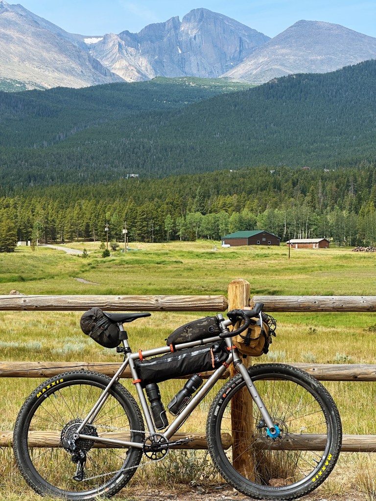
Boulder and Steamboat Springs are steeped in the cycling culture and lore. So why not strap some bags to your bike and ride over some high alpine passes, linking them together in one mega route? This 354-mile route (intended to be ridden counter-clockwise) with lots of elevation gain will test your full adventure skillset. Still, despite its numerous challenges, you’ll be rewarded with breathtaking views and countless opportunities for fantastic campsites and side quests along the way. Follow along as I give you a look into the route and what to expect along the way. Refer to the last paragraph for bike setup recommendations and other helpful tips for the route.

Leaving Boulder, there are numerous bike-friendly ways to get to Estes Park. For my selection, I recommend taking the North Sky Trail to Joder Ranch, Lefthand Canyon, and then up through Jamestown to reach the Peak to Peak Highway. It is an excellent mix of dirt and pavement that feels efficient and somewhat direct. You’ll feel like you’re making progress, and the scenery changes quickly. Other options exist, so check the map and find what works for your setup and riding style. I like balancing interesting dirt options, but nothing too slow or tedious, as this is a big loop! You have places to be!

Once you arrive at the Peak-to-Peak Highway, you’ll be smooth sailing on a wide shoulder and excellent tarmac all the way to Estes Park. The P2P is a Boulder County classic, so don’t forget to take in the views of the Indian Peaks and the infamous Longs Peak as you pedal by. In Estes, stock up on supplies and grab some food. Numerous options exist, and you’ll have no problem finding something to eat. 

Now onto the first big climb of the trip: Old Fall River Road. Once you pay the park entry fee and enter RMNP, the fun stuff begins. Enjoy this magnificent dirt climb up to 11,796ft. The grade is perfect and the views are stunning. Heads up, this is a one-way road, so make sure to keep an ear out for cars wanting to pass from behind. Also, it’s not uncommon to find elk on the road, so another point of caution.

Once atop the pass, buckle in for one of the craziest road descents you’ll ever do. It’s smooth sailing all the way down to Grand Lake. Camping options are available along the way, so be sure to call ahead and book a reservation in advance. Lodging options are available on HWY 34 through Grand Lake and Granby, so research ahead of time if that’s something you’re looking to do. Resupply in Grand Lake or hit the Gas Station in Granby before Willow Creek. You’ll be on pavement for a long stretch without services. Turn on that rear blinky light. There is a comfortable shoulder the whole way, and I never felt like it was sketchy. That being said, it’s a busier road, so proceed with caution and be alert.

I’ll repeat it, you’ll be on pavement without services for a long time (almost 90 miles!), so stock up in Granby. Your next resupply is Steamboat Springs. The next stretch is remote and beautiful, and will be worth the solitude. If you’re looking to ride more dirt, check out Illinois/Stillwater Pass. It was closed when I rode this route, so please check online before committing to it.

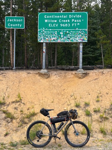
After Willow Creek Pass, you’ll enjoy wide open spaces and sagebrush. As you cruise through North Park, you’ll have a mix of fast pavement and dirt roads. Make the long push over to the base of Buffalo Pass, your final obstacle before charging down into Steamboat. From the east, Buffalo Pass is a gentle, smooth climb. Down the west, it’s chunky and steep! You’ll be screaming down to Steamboat Springs soon enough. Want to hit some singletrack? Cruise down Flash of Gold and get a taste of the iconic trails that made this place famous. 

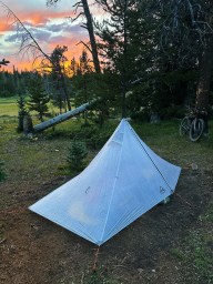
In Steamboat, you’ll find everything you need to recover and get motivated for the ride back to Boulder. You’ll be hopping on the iconic Great Divide Mountain Bike Route and feel where many legends have ridden before you. Soak it in—This is one of the premier stretches of the route. You’ll find camping and places to filter water near the top of Lynx Pass before leaving the GDMBR for Gore Pass. Don’t miss the cutoff turn, as this skips pavement and extra miles down to Kremmling. On the second half of the route, resupplies become more frequent. You’ll rejoin the GDMBR through Williams Fork, then head up Keyser Creek to Church Park. Excellent views and dispersed camping are easily accessible on this climb, as well as at the summit.

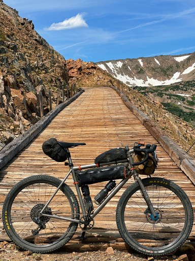
Only a few obstacles stand in your way from Boulder. Ride down to Fraser and the Winter Park valley and get ready for the crux of the ride. Rollins Pass. It’s easy cruising up from the West, but the real challenge lies in the descent. Ride over the historic trestles and do your only real hike-a-bike of the trip. It’s worth it for the views! The descent is rocky, enough said. Stay with it and don’t get frustrated. It’s the last real challenge of the route, and you got this. Once you hit Tolland Road. It’s fast dirt back down to Rollinsville. Stop by Melt for a coffee or beer, and get psyched for the final stretch of the trip. It’s the famous Magnolia Road. Rolling dirt miles will bring you to a screaming fast paved descent down to Boulder Canyon. Hop onto the creek path at Chapman Drive and coast down into Boulder. The loop is complete! 

Bring your widest tires! 2” minimum. You’ll want the wide tires for Buffalo and Rollins Pass. You’ll also want to have plenty of water and food storage. There are some long stretches (Granby to Steamboat, specifically) with almost no resupply. This route holds snow until midsummer. The best time to ride is from July through the end of September. It’s a short window, given the high-elevation mountain passes. Lights! Bring your front and taillights for visibility along busier stretches of road. Have more questions? Send me a DM on Instagram @kylerichardson. Enjoy!

September 26, 2025
0 FacebookTwitterLinkedinRedditEmail
AdventuresGaia GPS

Trip Report: A Rider’s Guide to the South Platte’s Best Trails and Roads

by Kyle Richardson August 27, 2025
written by Kyle Richardson

The South Platte is one of my favorite zones in Colorado. Just outside the Denver metropolitan area lies an incredible network of mixed-surface roads and singletrack. Over the past five years, I’ve been refining this 157-mile route to highlight the most iconic trails and roads while fully circumnavigating the area. My goal in designing this route was to create a curated, thoughtful experience—offering enjoyable, low-stress riding with easy resupply points, all within a landscape that still feels wild and remote. This route is meant to be accessible for riders of all levels and can be completed over a variety of days depending on skill, fitness, and motivation. This route is best ridden in the Fall or Springtime; avoid summer as the hot temperatures and exposed terrain make for sub-optimal conditions. In winter, you will likely run into snowy, unrideable roads at the higher elevations. (The route tops out over 9,000ft in elevation)

This route was designed to be enjoyed on a variety of bikes—so ride what you have! For the best experience, I recommend running at least a 2” tire for added comfort and security on the trails. If you’re on something smaller, no worries—just take it easy in the sandy corners. Whether you’re on a rigid setup or full suspension, both will shine at different points along the way, as this route truly has a little bit of everything.

Starting at Reynolds Park just outside of Conifer, Colorado, riders are immediately rewarded with one of the best downhill stretches of flowy singletrack in the state. Don’t be discouraged by the short hike-a-bike at the start—it’s brief and absolutely worth it. From there, the trail drops smoothly all the way to the South Platte River. Expect roller-coaster-style terrain, epic views of the Cathedral Spires, and nonstop fun that will have you and your friends grinning ear to ear, hooting and hollering the whole way down.

The next stretch to Deckers is fast and smooth, blending dirt and pavement with plenty of opportunities to cool off in the river along the way. Don’t miss the chance for a swim as you ride riverside. In Deckers, you’ll find a few small amenities, but be sure to double-check the grill and convenience store hours before rolling out (see waypoints attached to the GPX). From there, it’s about 10 miles to West Creek—the gateway to the southern section of the South Platte. While several route options branch out here, I recommend the Turkey Rocks variation for its incredible campsites and the remote, wild feel it offers.

After descending into Florissant (a key resupply), the ride over to Lake George is a highlight of the route. The climb up to Wolf Tongue, followed by the doubletrack descent into Elevenmile Canyon, feels both sneaky and beautiful—winding through aspen forests before dropping to the roaring river. You’ll find plenty of great camping and picnic spots along this stretch.

At Lake George, you’ll hit your final major reliable resupply. Stock up on food here before heading out. A short stretch of busy pavement leads to Tarryall Road, where rolling hillsides and rugged peaks set the stage. Soon after, you’ll turn onto the infamous Matukat Road—arguably one of the most epic dirt roads in the South Platte. From here, it’s almost entirely dirt until the final paved climb back to Reynolds Park. Matukat dishes out massive views of Pikes Peak and the entire South Platte, with winding turns and striking granite formations that feel pulled straight from Yosemite. Camping is plentiful, both at established sites and dispersed spots. Be sure to stop at Goose Creek Campground for water and a refreshing leg soak.

The subsequent climbs up to Stony Pass can be steep and exposed, but pacing yourself pays off with incredible views. If you’re running low on energy, it’s easy to pull over and camp here without pressure to push on.

From Stony Pass, you drop into the Buffalo Creek zone—home to some of Colorado’s finest singletrack. Flowy trails for miles await. Follow the GPX for the best experience, though quicker, more direct options exist. Gaia GPS is your best friend here; lots of options exist, all at an approachable level of difficulty. With the Trailforks layer toggled on, you can dive a bit deeper and check out all of the trails in the area, or bookmark certain trails for future rides. After the climb up Nice Kitty, you’ll get a taste of the Colorado Trail by riding Segment 2. This stretch is fast, flowy, and mostly downhill. Before the final climb back to your car at Reynolds Park, take time to refill water and cool off at the South Platte River—a perfect finish to this big adventure.

Have questions or comments? Feel free to shoot me a DM on Instagram @kylerichardson or email me at kylerichardson.atx@gmail.com

August 27, 2025
0 FacebookTwitterLinkedinRedditEmail
Load More Posts

Categories

  • Adventures
  • Android
  • App Comparisons
  • App Updates
  • Backcountry Skiing
  • Boating
  • Company News
  • Emergency Response
  • Featured
  • Fishing
  • Gaia GPS
  • Gaia GPS Offroad Podcast
  • GaiaCloud
  • Hikes
  • How-To
  • Hunting
  • iOS
  • New Features
  • New Maps
  • Newsletter
  • Offroading
  • Out and Back Podcast
  • Overlanding
  • User Profiles

Recent Posts

  • Trip Report: A Rider’s Guide to link Boulder and Steamboat Springs
  • Trip Report: A Rider’s Guide to the South Platte’s Best Trails and Roads
  • Battling the Wind: Setting Your Shocks to Firm Helps on Overland Drives
  • The Hike Map That Broke Me: How Gaia GPS Turned an Overlander Into a Reluctant Hiker
    • Facebook
    • Twitter
    • Instagram
    • Youtube
    • RSS
    • Explore The Map
    • Get the App
    • Upgrade Today
    • Explore The Map Catalog
    • New Features
      • Gaia GPS

        The Hike Map That Broke Me: How Gaia…

        April 24, 2025

        Gaia GPS

        Introducing the Gaia Hike Map: Plan Your Hike,…

        March 18, 2025

        Gaia GPS

        Unlock a New Level of Personalization in Gaia…

        December 12, 2024

        Gaia GPS

        Goodbye Clutter, Hello Streamlined Maps: Introducing Sync to…

        November 26, 2024

        Gaia GPS

        Discover Prime Stargazing Locations with Our New Light…

        August 15, 2024

        Gaia GPS

        2023 Mapped: Our Best New Features of the…

        December 27, 2023

        Gaia GPS

        Discover Adventure Easier Than Ever with New Map…

        July 27, 2023

      • New Maps
        • Gaia GPS

          Introducing the Gaia Hike Map: Plan Your Hike,…

          March 18, 2025

          Gaia GPS

          Discover Prime Stargazing Locations with Our New Light…

          August 15, 2024

          Gaia GPS

          Find Prime Viewing for Total Solar Eclipse with…

          March 27, 2024

          Gaia GPS

          See the World More Clearly with New Gaia…

          May 18, 2023

          Gaia GPS

          Gaia Classic: The Only Map You’ll Ever Need?

          May 4, 2023

          Backcountry Skiing

          Find Backcountry Skiing in Gaia Winter Map

          January 11, 2023

          Gaia GPS

          Our Favorite New Maps and Features

          December 23, 2022

    • Activities
      • Backcountry Skiing
      • Boating
      • Emergency Response
      • Fishing
      • Offroading
    • Adventures
      • User Stories
    • Help

    @2024 - All Right Reserved. Gaia GPS


    Back To Top