Top Posts
Introducing Adventure Modes: The Right Map for Every...
Trip Report: A Rider’s Guide to Bikepacking in...
How to Hike a Colorado 14er: A Step-by-Step...
Trip Report: A Rider’s Guide to link Boulder...
Trip Report: A Rider’s Guide to the South...
Battling the Wind: Setting Your Shocks to Firm...
The Hike Map That Broke Me: How Gaia...
A Fond Farewell to National Geographic Maps —...
Introducing the Gaia Hike Map: Plan Your Hike,...
Download the app and get a free 14-day...
Gaia GPS
  • Explore The Map
  • Get the App
  • Upgrade Today
  • Explore The Map Catalog
  • New Features
  • Activities
    • Backcountry Skiing
    • Boating
    • Emergency Response
    • Fishing
    • Offroading
  • Adventures
    • User Stories
  • Help
Tag:

new feature

Gaia GPSNew Features

Introducing Adventure Modes: The Right Map for Every Adventure in One Tap

by Eric Evans August 13, 2026
written by Eric Evans

There’s a certain kind of person who shows up at the trailhead with three different plans. Maybe it’s a hike if the snow looks manageable. Maybe it’s a ski tour if it doesn’t. Maybe it turns into a full-on off-road detour because someone spotted a Forest Service road that looked too good to ignore. You know who you are. We built this for you.

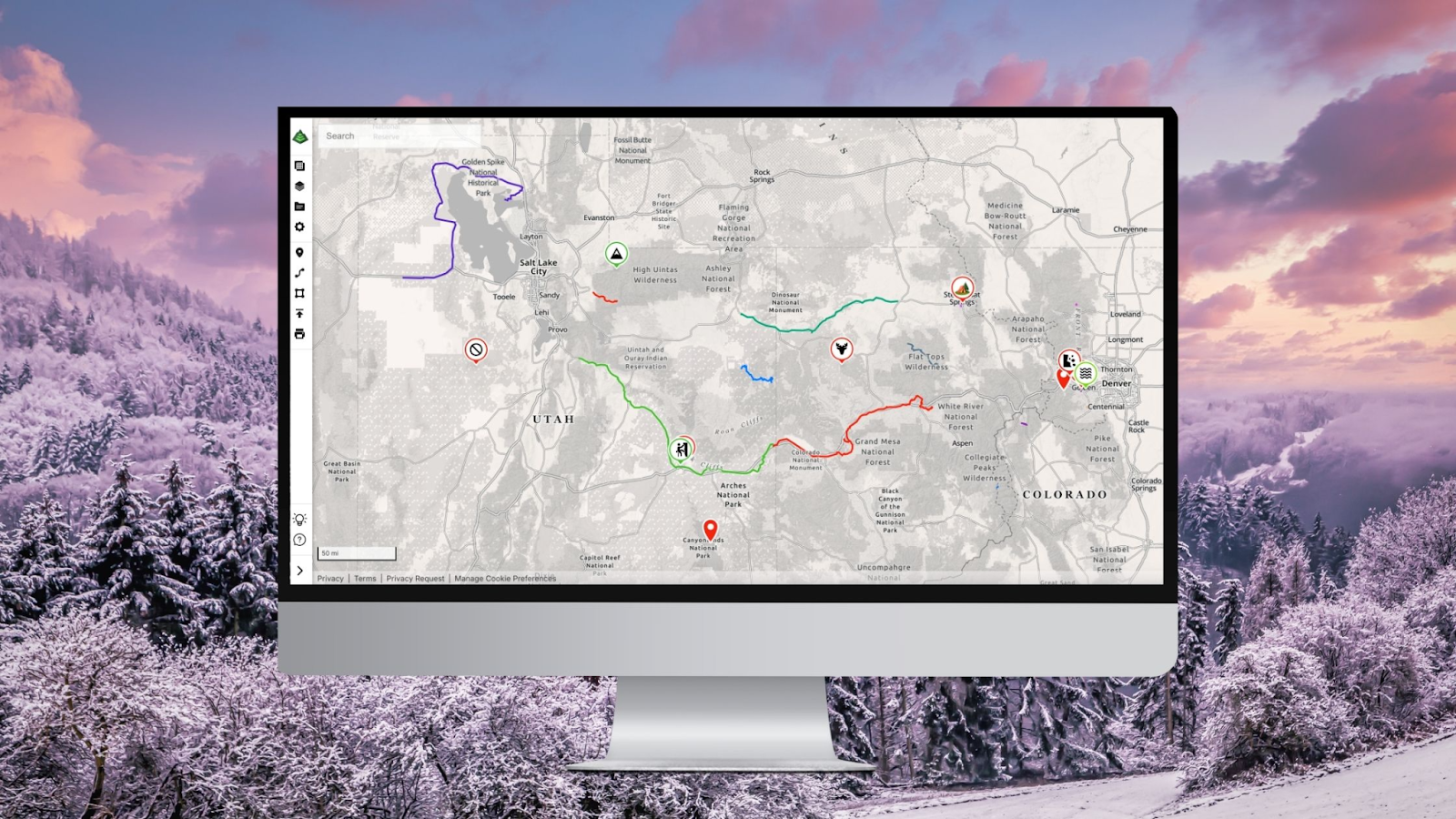
Today, we’re launching Adventure Modes, and it’s the biggest change to how Gaia GPS works since, well, Gaia GPS. Adventure Modes sets up your map with all the right data and layers for however you hit the trail.

One App. Every Adventure. Zero Reconfiguring.

Here’s the thing about the outdoors: it doesn’t care about your app’s information architecture. A weekend can start as a snowshoe, pivot to a ski descent, and end with you airing down the tires for a dirt road you definitely didn’t plan on. Until now, your map couldn’t keep up.

Adventure Modes changes that. Every mode is built around what your activity actually demands. It’s one map, purpose-built for however you’re getting out there.

When you launch Gaia GPS on the web or app, you’ll find three new modes waiting for you:

  • Hike – Trail overlays, terrain shading, waypoints, and the layers that matter when you’re moving on foot. Whether it’s a casual walk or a 14-day traverse, your map is dialed for the trail.
  • Off-Road – Surface type, road classifications, 4×4 tracks, and satellite imagery front and center. The map your rig deserves, ready before you hit the dirt.
  • Snow – Slope angle shading, avalanche zones, snowpack layers, and Nordic routes. Because going into the mountains in winter with a summer hiking map is how epics turn into incidents.

Switch between them with a single tap. No settings menus. No digging through layer toggles. No, “Wait, why is this map showing me bike trails when I’m on snowshoes?” Just the right map for the right adventure, right now.

Adventure Modes makes dialing in your map quicker and simpler than ever before. Pick your activity, adjust what you need, and Gaia GPS remembers your setup the next time you head out.

Your Map, Your Way – Without the Setup Tax

We’ve all been there. You open a mapping app, and before you can even look at the terrain, you’re configuring layers, toggling sources, and wondering why the app thinks you want cycling infrastructure when you’re planning a ski tour.

Adventure Modes eliminates that entirely. Every mode comes pre-loaded with the basemaps and overlays you need to adventure with confidence. Hike mode doesn’t clutter your screen with off-road tracks. Snow mode isn’t hiding your slope angle data three menus deep. Off-Road mode has the satellite imagery you need without you having to go looking for it.

And if you want to customize further? Custom Mode brings you back to the original Gaia GPS experience. It works the same as always – full flexibility, no restrictions. Build your map setup however you want with our deep layer library of USGS quads, aerial imagery, slope shading, and dozens more. Use it like another mode whenever you want complete control.

For the People Who Don’t Just Do One Thing

Most outdoor apps are built for one type of adventurer. Hike this trail. Follow this route. Stay in your lane — literally.

Gaia GPS has always attracted a different crowd. The people who hike out and ski back. Who overland to the trailhead and then hike to the summit. The crowd who knows that the best adventures usually start with a plan and end somewhere completely different.

Adventure Modes is built for exactly that kind of person. You’re not a hiker or an off-roader or a backcountry skier. You’re all of those things depending on the day, the season, and what the road looks like. Now your map works the same way.

Available Now on Web and Mobile

Adventure Modes is live today on Gaia GPS on the web and mobile. No waitlist, no setup, just open your map, pick your mode, and go.

If you’re new here – welcome. There’s a lot of world out there, and we’ve been mapping it obsessively for a long time. Adventure Modes is the best place to start.

If you’re a longtime Gaia user, you’re going to feel this immediately. The app you already trusted just learned how to read the room.

Try Adventure Modes on the web, Android, or iOS app now.

Hike far. Drive deep. Ski everything. We’ll handle the map.

August 13, 2026
0 FacebookTwitterLinkedinRedditEmail
Gaia GPSNew Features

Unlock a New Level of Personalization in Gaia GPS with Photo Waypoints

by Jules Semotuk December 12, 2024
written by Jules Semotuk

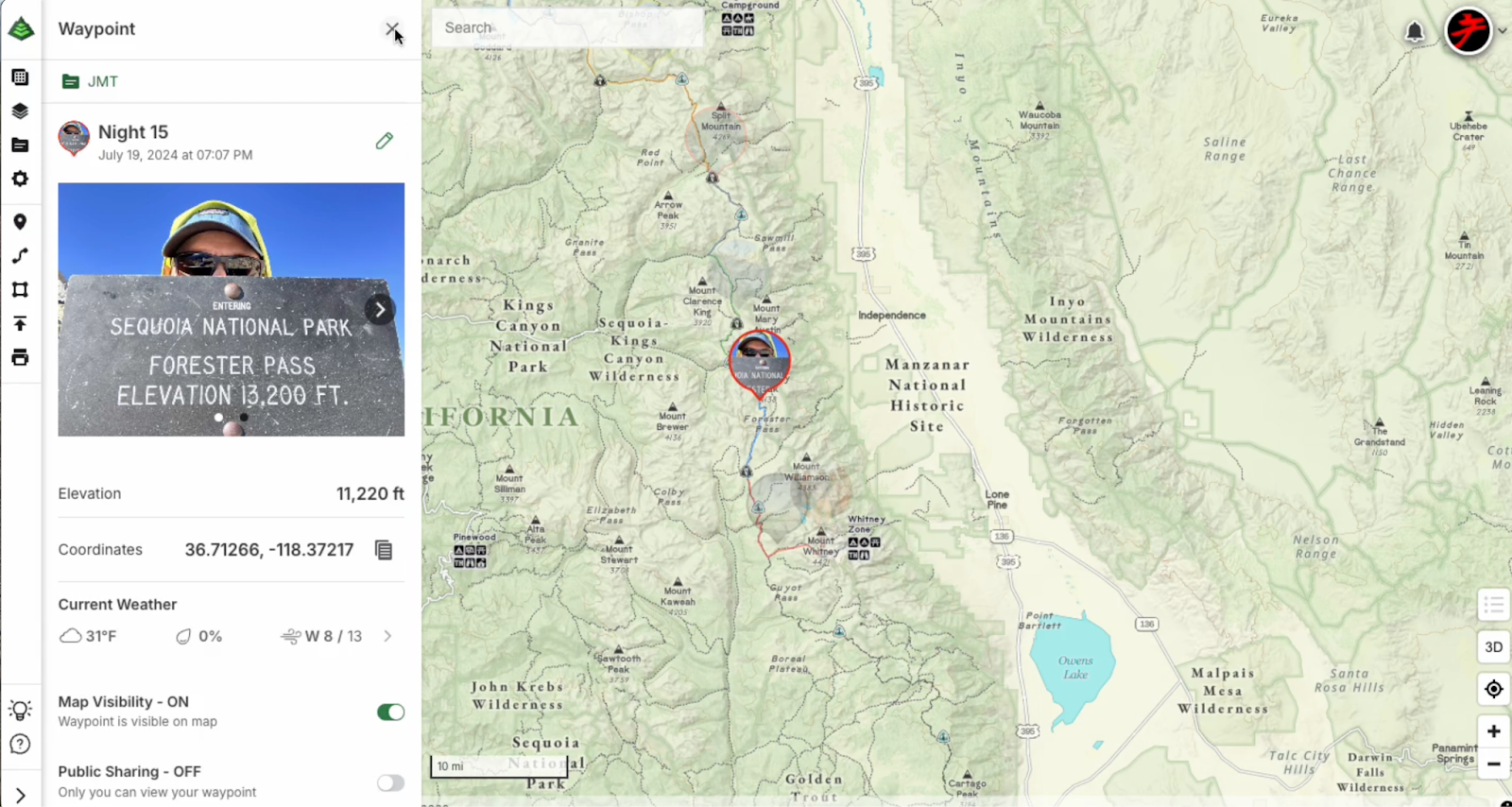
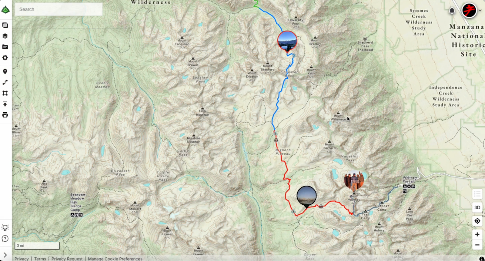
Get ready to elevate your Gaia GPS adventures with the brand-new photo waypoint feature! While emoji icons are fun for marking locations, this exciting update lets you add images to your waypoint icons, taking your map personalization to the next level. With Photo Waypoints, you can make your maps more personal and visually rich, helping you navigate with greater ease and relive your experiences in a whole new way. Whether you’re out exploring, planning your next pursuits, or perhaps revisiting previous journeys, this upgrade transforms your maps into a truly personal and visually stunning experience. 

Photo Waypoints Are Available on the Web with Gaia GPS Premium

Photo Waypoints are a premium feature exclusively available on the Web with a Gaia GPS Premium or an Outside+ membership. With a subscription, you’ll unlock Photo Waypoints along with an array of other premium features to enhance your outdoor experience, including our 300-plus map catalog, offline navigation, and more.

How It Works

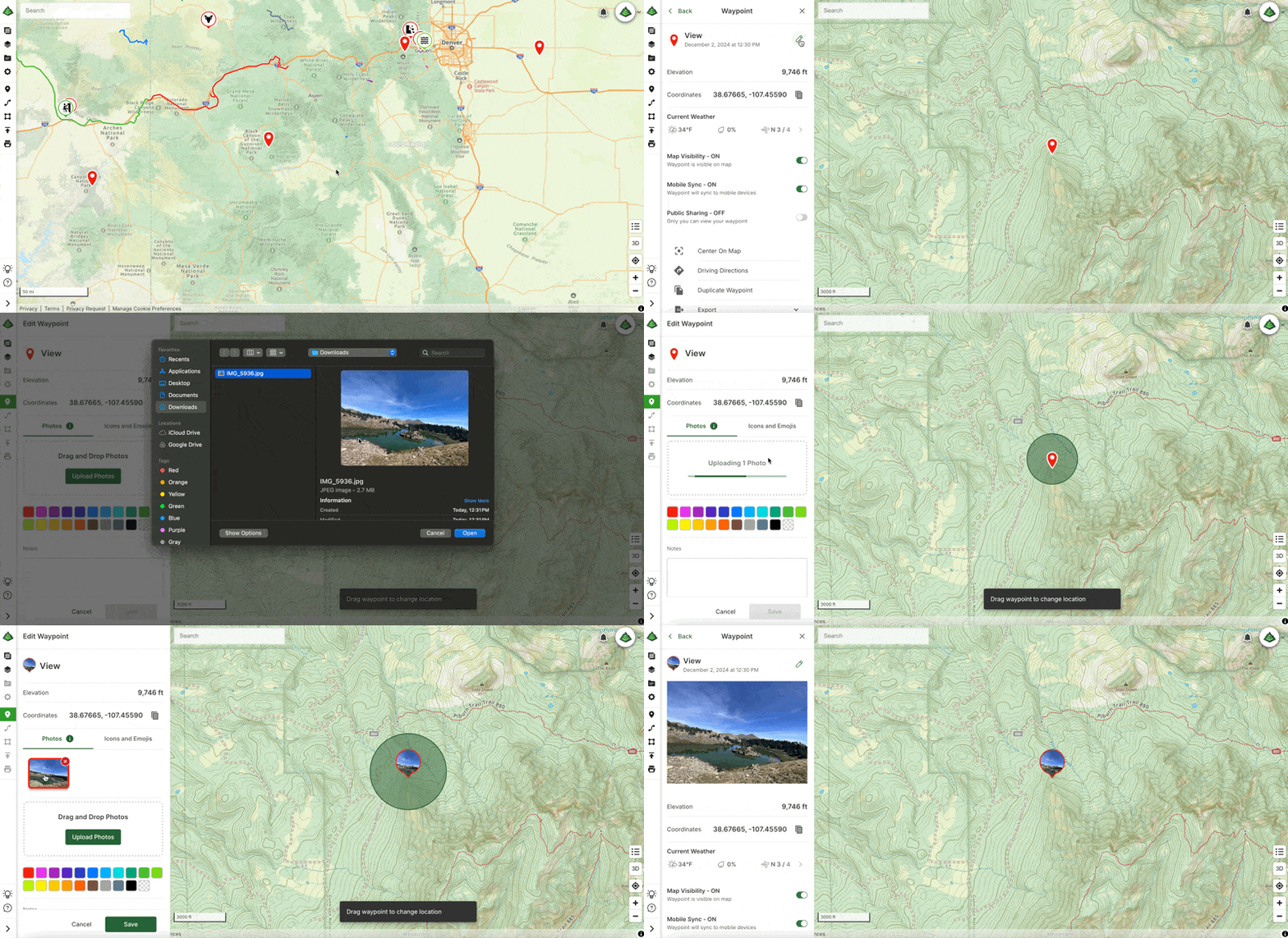
Creating Photo Waypoints on the web as a Gaia GPS Premium user is easy and just takes a few steps. Here’s how: 

  1. Visit gaiagps.com on your desktop. Log in or create an account. 
  2. Select a waypoint you would like to edit from the Saved Items sidebar.
  3. Click the pencil icon to the right of the waypoint title to edit the waypoint.
  4. If not already selected, click the Photos tab and then click ‘Upload Photos.’ 
  5. Once your photo(s) are uploaded, choose a photo to use as the waypoint icon photo, then click save!

That’s it! Now your waypoint has a personalized touch, adding a new layer of meaning to your adventure.

Personalize Your Adventure with Gaia GPS

Gaia GPS empowers you to create personalized, detailed, and memorable maps that enhance your preparation and documentation of your outdoor experiences. With the new Photo Waypoint feature, you can use images to capture and recall key locations along your journey. Whether you are an outdoor enthusiast documenting new hikes and viewpoints, a traveler looking to mark destinations and favorite spots on the road, or a photographer creating a photo journal of your outdoor excursions, the Photo Waypoint feature is here to help you transform your maps into visual representations of your unique experiences. 

Begin Customizing Your Maps Today

Ready to make your next adventure even more memorable? Dive into our easy Help Center guide on creating and editing waypoints, and start customizing your maps today! Learn more here: Edit Waypoints on gaiagps.com

December 12, 2024
0 FacebookTwitterLinkedinRedditEmail
Gaia GPSNew Features

Goodbye Clutter, Hello Streamlined Maps: Introducing Sync to Mobile

by Jules Semotuk November 26, 2024
written by Jules Semotuk

Have you ever found yourself scrolling through your Gaia GPS app, searching for that one piece of data you need, only to get lost in a sea of old adventures you’ve already completed? It’s time to put that behind you! Say goodbye to clutter in the app, and hello to a more streamlined mapping experience. 

Meet Sync to Mobile – a new feature that lets you tailor your sync preferences to decide what data you want on your mobile device, all while keeping all your data viewable on gaiagps.com. This new feature makes managing your data in Gaia GPS easier than ever and ultimately completes the lifecycle of your adventures.

Sync Only What You Need 

As the new year approaches, it’s a great time to declutter, both physically and digitally. If you’ve been using Gaia GPS for a while, you’ve probably noticed an accumulation of old data on your device. Maybe it’s a swarm of waypoints from a long-forgotten trip or a track you recorded years ago. It’s great to have memories of your adventures, but let’s be honest—do you need every old route and track synced to your mobile device when you’re heading out on a new adventure? 

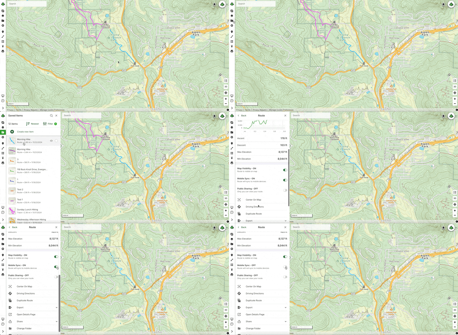
Gone are the days of having to sync all of your data to the app. Now, Sync to Mobile allows you to focus on what you currently need in the app, while still preserving your memories and data on the web. Think of the web platform as hanging a paper map on your wall to plan and remember your life’s adventures, and let the app be focused on data for your current endeavor. Here’s how to use the new Sync to Mobile feature: Organize Your Data with the Sync to Mobile Feature on Gaiagps.com.

From Planning to Reflection

Gaia GPS has always been a powerful tool for both planning and navigating your outdoor excursions. The new Sync to Mobile feature takes it a step further by allowing you to manage your data across devices with greater control. Imagine Gaia GPS as the ultimate command center for your adventures—the web interface is your mission control, where you can plan and organize your trips, while your mobile device is your trusty companion in the field.

Sync to Mobile enables you to select exactly which data (tracks, routes, waypoints, etc.) you need on the app for a particular trip—whether you’re heading out on a multi-day overlanding adventure or just going for a day hike. By utilizing this feature, you not only reduce the clutter on your mobile device, but less data on the app also decreases loading times, ultimately upgrading the Gaia GPS app’s performance and efficiency. 

Once you’ve finished your trip, turn Sync to Mobile off on the data you no longer wish to sync to your device. You’ll still be able to see your saved data on the web—so don’t worry, your past trips will be there for reminiscing. However, by turning off Mobile Sync for completed trips, you can decrease loading times and improve the performance of the Gaia GPS app. A win-win, if you ask me!

A Smarter Way to Archive

With Sync to Mobile, the archiving feature takes on a new role. In the past, archiving was your way of managing what data you didn’t want synced to your device, but this had the side effect of removing that data from the web map as well. Now, you can selectively choose which data you want synced to mobile without the hassle of archiving. This is a game-changer for anyone who likes to keep a record of their adventures without being weighed down by unnecessary data while you’re on the go. Moving forward, you can think of archiving as a soft delete, rather than a sync management tool. Items can still be restored from an archived state (or deleted permanently), similar to how the trash can works on a computer’s operating system.   

How to Get Sync to Mobile

Anyone with a Gaia GPS account can take advantage of this new feature on the web at gaiagps.com. If you also want access to premium maps and features, you can upgrade to a Gaia GPS Premium or an Outside+ membership. 

Gaia GPS Premium or Gaia GPS with Outside+ gives you access to the entire 300+ map catalog. With Premium, you can also download maps for offline use so you can find your way—even without cell service. You can layer maps together to reveal even more terrain, weather, and safety features. And you can print custom maps.

With Outside+, you’ll also receive unlimited access to digital content from Outside and 15 other brands—think recipes, meal plans, and training tips from Backpacker, RUN, and more. Explore new routes with Trailforks Pro, and stream 600+ hours of ski and climbing action, survival challenges, travel documentaries, and more with Outside TV.

So, what are you waiting for? Try Sync to Mobile today for your next adventure with Gaia GPS!

November 26, 2024
0 FacebookTwitterLinkedinRedditEmail
Load More Posts

Categories

  • Adventures
  • Android
  • App Comparisons
  • App Updates
  • Backcountry Skiing
  • Boating
  • Company News
  • Emergency Response
  • Featured
  • Fishing
  • Gaia GPS
  • Gaia GPS Offroad Podcast
  • GaiaCloud
  • Hikes
  • How-To
  • Hunting
  • iOS
  • New Features
  • New Maps
  • Newsletter
  • Offroading
  • Out and Back Podcast
  • Overlanding
  • User Profiles

Recent Posts

  • Introducing Adventure Modes: The Right Map for Every Adventure in One Tap
  • Trip Report: A Rider’s Guide to Bikepacking in Bears Ears National Monument
  • How to Hike a Colorado 14er: A Step-by-Step Guide with Gaia GPS
  • Trip Report: A Rider’s Guide to link Boulder and Steamboat Springs
    • Facebook
    • Twitter
    • Instagram
    • Youtube
    • Rss
    • Explore The Map
    • Get the App
    • Upgrade Today
    • Explore The Map Catalog
    • New Features
    • Activities
      • Backcountry Skiing
      • Boating
      • Emergency Response
      • Fishing
      • Offroading
    • Adventures
      • User Stories
    • Help

    @2024 - All Right Reserved. Gaia GPS


    Back To Top
    Gaia GPS
    • Explore The Map
    • Get the App
    • Upgrade Today
    • Explore The Map Catalog
    • New Features
    • Activities
      • Backcountry Skiing
      • Boating
      • Emergency Response
      • Fishing
      • Offroading
    • Adventures
      • User Stories
    • Help